

<< Our Photo Pages >> Toldnes cairns - Barrow Cemetery in Norway in Nord-Trøndelag
Submitted by kenntha88 on Saturday, 09 September 2017 Page Views: 817
Neolithic and Bronze AgeSite Name: Toldnes cairnsCountry: Norway Fylke: Nord-Trøndelag Type: Barrow Cemetery
Nearest Town: Steinkjer
Latitude: 63.977018N Longitude: 11.386364E
Condition:
| 5 | Perfect |
| 4 | Almost Perfect |
| 3 | Reasonable but with some damage |
| 2 | Ruined but still recognisable as an ancient site |
| 1 | Pretty much destroyed, possibly visible as crop marks |
| 0 | No data. |
| -1 | Completely destroyed |
| 5 | Superb |
| 4 | Good |
| 3 | Ordinary |
| 2 | Not Good |
| 1 | Awful |
| 0 | No data. |
| 5 | Can be driven to, probably with disabled access |
| 4 | Short walk on a footpath |
| 3 | Requiring a bit more of a walk |
| 2 | A long walk |
| 1 | In the middle of nowhere, a nightmare to find |
| 0 | No data. |
| 5 | co-ordinates taken by GPS or official recorded co-ordinates |
| 4 | co-ordinates scaled from a detailed map |
| 3 | co-ordinates scaled from a bad map |
| 2 | co-ordinates of the nearest village |
| 1 | co-ordinates of the nearest town |
| 0 | no data |
Internal Links:
External Links:
")
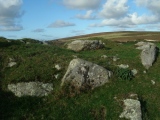
Most barrow cemeteries I visit are from the iron age but this cemetery dates from the bronze age making it very interesting as there are very few cemeteries dating back to the bronze age, most consist of single large burial cairns. The cemetery and cairns were covered in thick forest until just a few years ago but some of them have been cleared for vegetation and signposts have been set up at the main highway and also a large information poster at a small parking lot. The cairns are located along a walking path.
The smaller cairns range in size from just around 6 metres in diameter to around 10 metres. They are the most difficult to find. The largest are around 20 metres in diameter and the largest is around 22 metres across and 2 metres in height. It has a small standing stone on top. Standing stones on bronze age cairns are rare. The standing stone is around 70cm in height and around 20cm wide and has a pointy top. The cairn also have a deep crater in the side.
In total there are around 40 cairns in either single cairns or groups. Some of them are quite large and some of them have several burial chambers. 20 of the cairns have been excavated containing a total of 48 individuals. A number of grave goods have been found, a lof of jewelry, knifes, daggers and axes made in bronze have been found over the years suggesting the people once living here had a wealthy culture.
You may be viewing yesterday's version of this page. To see the most up to date information please register for a free account.
")
")
")
")
")
")
")
")
Do not use the above information on other web sites or publications without permission of the contributor.
Click here to see more info for this site
Nearby sites
Click here to view sites on an interactive map of the areaKey: Red: member's photo, Blue: 3rd party photo, Yellow: other image, Green: no photo - please go there and take one, Grey: site destroyed
Download sites to:
KML (Google Earth)
GPX (GPS waypoints)
CSV (Garmin/Navman)
CSV (Excel)
To unlock full downloads you need to sign up as a Contributory Member. Otherwise downloads are limited to 50 sites.
Turn off the page maps and other distractions
Nearby sites listing. In the following links * = Image available
794m S 179° Limbuhaugen* Cist
2.0km E 86° Vistavegen* Cairn
2.1km SE 142° Vist burial mound* Round Barrow(s)
3.1km S 179° Kvitvang barrow cemetery* Barrow Cemetery
3.6km SE 133° Ålberg* Barrow Cemetery
4.3km SSE 150° Lian barrow* Round Barrow(s)
4.4km ENE 65° Skrubbhaugen* Barrow Cemetery
4.5km SSE 149° Lianhøgda* Cairn
4.9km NNE 30° Skåtangen* Cairn
4.9km N 352° Hoøya Cairns* Cairn
5.0km SSE 146° Jøremsvegen Phallic Stone* Sculptured Stone
5.2km SE 144° Leinsmyra-Jørem* Barrow Cemetery
5.3km W 263° Grønnesby Søndre* Cairn
5.4km W 260° Søndre Grønnesby Boat House* Ancient Village or Settlement
5.5km W 262° Frammigar`n* Cairn
5.5km SE 146° Jørem* Round Barrow(s)
5.8km WSW 252° Storberget* Hillfort
6.2km NE 37° Bergkunstmuseet / Egge Museum Museum
6.4km NE 39° Egge West Eggevammen* Barrow Cemetery
6.8km ENE 63° Ner-Trana Mounds* Barrow Cemetery
7.1km SSE 148° Sparbu barrows* Barrow Cemetery
7.1km ENE 67° Tranaskogvegen* Barrow Cemetery
7.3km NE 40° Olvisheim Stone Rings* Stone Row / Alignment
7.3km NE 41° Egge East Olvisheim Stone Row / Alignment
7.3km NE 45° Tingvoll Stone Setting* Stone Circle
View more nearby sites and additional images


 We would like to know more about this location. Please feel free to add a brief description and any relevant information in your own language.
 Wir möchten mehr über diese Stätte erfahren. Bitte zögern Sie nicht, eine kurze Beschreibung und relevante Informationen in Deutsch hinzuzufügen.
 Nous aimerions en savoir encore un peu sur les lieux. S'il vous plaît n'hesitez pas à ajouter une courte description et tous les renseignements pertinents dans votre propre langue.
 Quisieramos informarnos un poco más de las lugares. No dude en añadir una breve descripción y otros datos relevantes en su propio idioma.