

<< Our Photo Pages >> Vist burial mound - Round Barrow(s) in Norway in Nord-Trøndelag
Submitted by kenntha88 on Thursday, 22 October 2009 Page Views: 3032
Neolithic and Bronze AgeSite Name: Vist burial mound Alternative Name: Nedre LøCountry: Norway Fylke: Nord-Trøndelag Type: Round Barrow(s)
Nearest Town: Trondheim Nearest Village: Steinkjer
Latitude: 63.961901N Longitude: 11.413593E
Condition:
| 5 | Perfect |
| 4 | Almost Perfect |
| 3 | Reasonable but with some damage |
| 2 | Ruined but still recognisable as an ancient site |
| 1 | Pretty much destroyed, possibly visible as crop marks |
| 0 | No data. |
| -1 | Completely destroyed |
| 5 | Superb |
| 4 | Good |
| 3 | Ordinary |
| 2 | Not Good |
| 1 | Awful |
| 0 | No data. |
| 5 | Can be driven to, probably with disabled access |
| 4 | Short walk on a footpath |
| 3 | Requiring a bit more of a walk |
| 2 | A long walk |
| 1 | In the middle of nowhere, a nightmare to find |
| 0 | No data. |
| 5 | co-ordinates taken by GPS or official recorded co-ordinates |
| 4 | co-ordinates scaled from a detailed map |
| 3 | co-ordinates scaled from a bad map |
| 2 | co-ordinates of the nearest village |
| 1 | co-ordinates of the nearest town |
| 0 | no data |
Internal Links:
External Links:
")
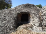
It is very close to the main highway (E6) and is very easy to see and visit. The mound is covered with grass and also some leaf and some pine trees, so it is hard to see the entire mound.
A good example of one of the many large single iron age burial mounds that seems to be almost everywhere in the area around Trondheimsfjord.
You may be viewing yesterday's version of this page. To see the most up to date information please register for a free account.
")
")
Do not use the above information on other web sites or publications without permission of the contributor.
Nearby Images from Flickr


The above images may not be of the site on this page, but were taken nearby. They are loaded from Flickr so please click on them for image credits.
Click here to see more info for this site
Nearby sites
Click here to view sites on an interactive map of the areaKey: Red: member's photo, Blue: 3rd party photo, Yellow: other image, Green: no photo - please go there and take one, Grey: site destroyed
Download sites to:
KML (Google Earth)
GPX (GPS waypoints)
CSV (Garmin/Navman)
CSV (Excel)
To unlock full downloads you need to sign up as a Contributory Member. Otherwise downloads are limited to 50 sites.
Turn off the page maps and other distractions
Nearby sites listing. In the following links * = Image available
1.5km ESE 120° Ålberg* Barrow Cemetery
1.6km NW 304° Limbuhaugen* Cist
1.9km NNE 19° Vistavegen* Cairn
1.9km SW 222° Kvitvang barrow cemetery* Barrow Cemetery
2.1km NW 322° Toldnes cairns* Barrow Cemetery
2.2km SSE 158° Lian barrow* Round Barrow(s)
2.4km SSE 156° Lianhøgda* Cairn
2.9km SSE 150° Jøremsvegen Phallic Stone* Sculptured Stone
3.0km SE 145° Leinsmyra-Jørem* Barrow Cemetery
3.4km SSE 148° Jørem* Round Barrow(s)
4.4km NE 37° Skrubbhaugen* Barrow Cemetery
5.0km SSE 150° Sparbu barrows* Barrow Cemetery
5.2km SE 131° Skei Settlement* Ancient Village or Settlement
6.0km N 11° Skåtangen* Cairn
6.6km W 279° Grønnesby Søndre* Cairn
6.7km W 276° Søndre Grønnesby Boat House* Ancient Village or Settlement
6.7km NE 45° Ner-Trana Mounds* Barrow Cemetery
6.8km W 278° Frammigar`n* Cairn
6.8km NNW 343° Hoøya Cairns* Cairn
6.9km W 269° Storberget* Hillfort
6.9km NE 49° Tranaskogvegen* Barrow Cemetery
7.1km NNE 20° Bergkunstmuseet / Egge Museum Museum
7.2km NNE 22° Egge West Eggevammen* Barrow Cemetery
7.4km ESE 116° Hollbruvegen-Heggstad* Round Barrow(s)
7.6km SW 224° Hommeldalen Standing Stones* Standing Stones
View more nearby sites and additional images


 We would like to know more about this location. Please feel free to add a brief description and any relevant information in your own language.
 Wir möchten mehr über diese Stätte erfahren. Bitte zögern Sie nicht, eine kurze Beschreibung und relevante Informationen in Deutsch hinzuzufügen.
 Nous aimerions en savoir encore un peu sur les lieux. S'il vous plaît n'hesitez pas à ajouter une courte description et tous les renseignements pertinents dans votre propre langue.
 Quisieramos informarnos un poco más de las lugares. No dude en añadir una breve descripción y otros datos relevantes en su propio idioma.