Featured: Exploring Avebury: The Essential Guide - New Expanded Edition!

Exploring Avebury: The Essential Guide - New Expanded Edition!

The Significance of Monuments

The Significance of Monuments

Login

Register here - as a registered user you get more features and fewer ads.

Who's Online

There are currently, 1286 guests and 8 members online.

Sponsors

<< News >> Mapping Mayan: LiDAR Reveals Further Secrets of Classical Guatemalan Cities

Submitted by bat400 on Tuesday, 06 February 2018  Page Views: 2262

DiscoveriesCountry: Guatemala
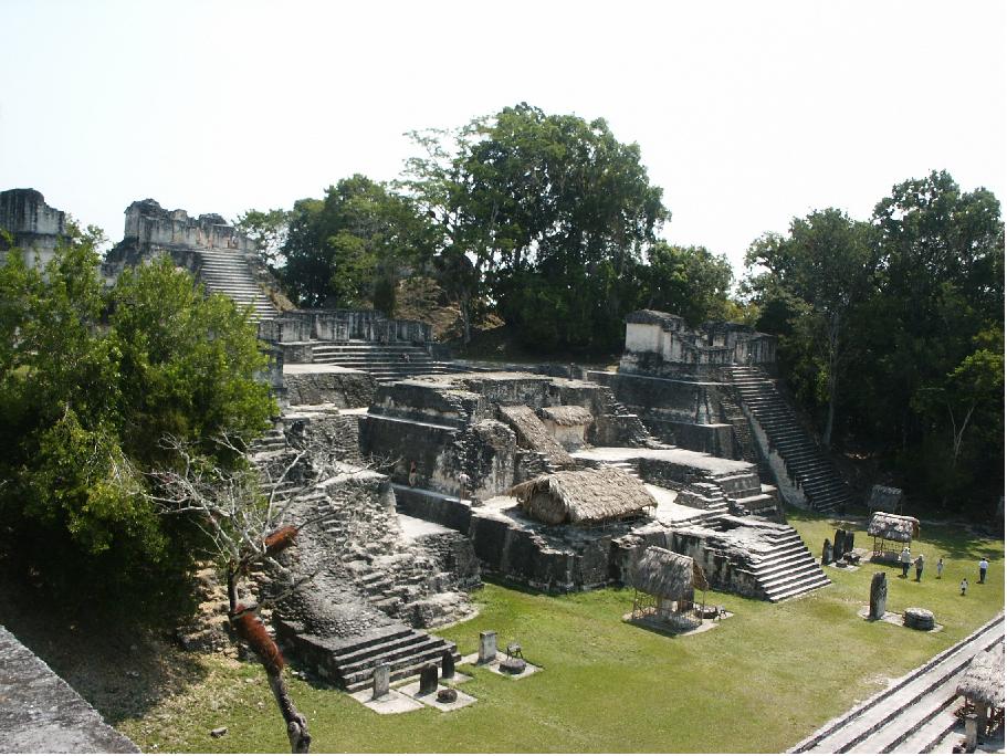
Tikal
Tikal submitted by bat400 : Tikal, Guatemala. Photo: B.Zerfas, 2008. (Vote or comment on this photo)
The results of LiDAR survey of 2,100-square kilometers surrounding Mayan sites in Guatemala's El Peten are revealing thousands of previously undocumented structures. Of major interest are structural features including irrigation and agricultural fields, and fortresses and linked watchtowers. The area mapped includes El Zotz and Tikal, where the survey may further expand the borders of this Mayan city-state.

Unlike previous ground surveys the LiDAR technique allows a much more rapid and complete recording of surface features and further analysis can pick out man made structures.
According to archaeologists Thomas Garrison, assistant professor of anthropology at Ithaca College, “Everyone is seeing larger, denser sites. Everyone,” Garrison said. “There's a spectrum to it, for sure, but that's a universal: everyone has missed settlement in their [previous] mapping.”

The LiDAR survey is a collaboration between archaeologists from the U.S., Europe and Guatemala, and the Fundación PACUNAM (Patrimonio Cultural y Natural Maya), a Guatemalan philanthropic and cultural heritage preservation organization. Researchers include Garrison of Ithaca College and Marcello A Canuto, a professor of anthropology at Tulane University.

For more see Ithaca College news release and
news from The Guardian.

Note: Detailed aerial images reveal a remarkably ambitious transportation network consisting of 17 roads, as well and the infrastructure for agriculture and defense.

<< Special Stonehenge Edition of Historic England Research magazine out now

New light shed on Stonehenge cremated remains >>

Please add your thoughts on this site

Build your own Stonehenge! (Model)

Build your own Stonehenge! (Model)

Sponsors

More News

See all News →

Latest Visit Logs

  • Mount Elizabeth Archeological Site
    “The shell midden, though being underneath a large mansion, is very conspicuous.”
    by IanMu4966 · 12 Jul 2026
  • Pompano Beach Indian Mound
    “Tricky to get parking, especially when the beaches are full. I can't imagine trying to find access i…”
    by IanMu4966 · 12 Jul 2026
  • Jeffers Mound
    “Quaint little Hopewell Culture barrow in a cul-de-sac.”
    by IanMu4966 · 12 Jul 2026
  • Luthor List Mound
    “A bit of bushwhacking to access the tumulus.”
    by IanMu4966 · 12 Jul 2026
  • St Helen's Well (Goodmanham)
    “One of my favourite local wells in East Riding as it is great for dog walking, and easy access from …”
    by Thirdstonefromthesun · 11 Jul 2026

"Mapping Mayan: LiDAR Reveals Further Secrets of Classical Guatemalan Cities" | Login/Create an Account | 1 comment
  
Go back to top of page    Comments are owned by the poster. We aren't responsible for their content.
Thousands of Maya Structures Discovered in Guatemala by bat400 on Wednesday, 07 February 2018
(User Info | Send a Message)
From Live Science:

"An aerial survey over northern Guatemala has turned up over 60,000 new Maya structures, including pyramids, causeways, house foundations and defensive fortifications.

"It's a watershed discovery that has already led archaeologists to new sites to excavate and explore. The findings may also revise estimates of how many ancient Maya once lived in the region upward by "multiple factors," said Tom Garrison, an archaeologist who specializes in the Maya culture and is part of the consortium that funded and organized the survey. Far more ancient Maya lived on the landscape than there are people in the region today, Garrison told Live Science, and they did it without the destructive slash-and-burn agriculture that is crippling the jungle in modern times.

"The finding of a sprawling Maya population shows there are means of supporting people in the area without destroying the forest, said Lisa Lucero, an anthropologist at the University of Illinois who was not involved in the new survey."

Source: http://www.livescience.com

Also: Photos at livescience
[ Reply to This ]

Your Name: Anonymous [ Register Now ]
Subject:


Add your comment or contribution to this page. Spam or offensive posts are deleted immediately, don't even bother

<<< What is five plus one as a number? (Please type the answer to this question in the little box on the left)
You can also embed videos and other things. For Youtube please copy and paste the 'embed code'.
For Google Street View please include Street View in the text.
Create a web link like this: <a href="https://www.megalithic.co.uk">This is a link</a>  

Allowed HTML is:
<p> <b> <i> <a> <img> <em> <br> <strong> <blockquote> <tt> <li> <ol> <ul> <object> <param> <embed> <iframe>

We would like to know more about this location. Please feel free to add a brief description and any relevant information in your own language.
Wir möchten mehr über diese Stätte erfahren. Bitte zögern Sie nicht, eine kurze Beschreibung und relevante Informationen in Deutsch hinzuzufügen.
Nous aimerions en savoir encore un peu sur les lieux. S'il vous plaît n'hesitez pas à ajouter une courte description et tous les renseignements pertinents dans votre propre langue.
Quisieramos informarnos un poco más de las lugares. No dude en añadir una breve descripción y otros datos relevantes en su propio idioma.