
Featured: Please Sign the Petition: Amend the Ancient Monuments Act to ban all building on Scheduled Sites

Please Sign the Petition: Amend the Ancient Monuments Act to ban all building on Scheduled Sites

Solving Stonehenge, the new key to an ancient enigma

Solving Stonehenge, the new key to an ancient enigma

Login

Register here - as a registered user you get more features and fewer ads.

Who's Online

There are currently, 706 guests and 2 members online.

Sponsors

Google Earth to uncover the past: I search out prehistoric remains from my desk

Submitted by coldrum on Thursday, 12 April 2012  Page Views: 4813

Discoveries
<< News >>

Shahmon Desert Kite
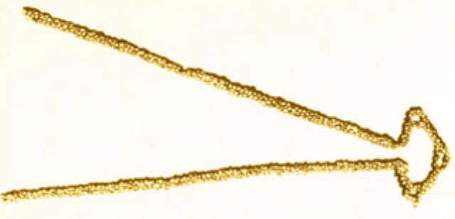
Shahmon Desert Kite submitted by motist : model of Sinai-Negev 'Desert Kite' (Vote or comment on this photo)
Archaeology is the study of the remains of the past but has long been predatory on the sciences and their ever-growing technologies. I was brought up as a student in 1970s Britain, when we learned of the wonderful revelations to be made through aerial viewing. Today we have astonishing virtual globes any one of us can use to explore many of the most remote and difficult places in the world. This was never clearer to me than during the past two years, when I began finding thousands of prehistoric sites in the Middle East … from my desk in Perth, Australia, using Google Earth.

Aerial reconnaissance for archaeology – Aerial Archaeology – has been an indispensable part of fieldwork in most of north-western Europe for decades. Hundreds of flights are dedicated annually to archaeology, which provide access to millions of aerial photographs. It would not be overstating it to say this technique has been transformational for the discipline.

Known sites and landscapes recorded cost-effectively, monitored routinely and mapped, as well as new discoveries, have all added to the database. In Britain, for example, the immense number of new sites recorded has transformed ancient landscape studies.

Although the Middle East witnessed important pioneering aerial reconnaissance in the 1920s and 30s it was largely confined to the British and French Mandates and ended with the Second World War and independence movements.

In the decades since, the landscape of the entire Middle East has been transformed through massive development, largely driven by a population explosion. In Jordan, for example, the population has increased by almost 2,000% since 1943, equivalent to an increase in Australia from the 7.5 million we had in 1947 to 150 million now. In short, the Middle East was deprived of one of the most powerful tools for discovery, recording, mapping and initial interpretation at the very time it was most needed.

It has always been relatively easy for archaeologists in Israel and Jordan to obtain aerial photographs and, since 1997, Jordan has supported me in an annual programme of aerial reconnaissance along with my colleague Dr Robert Bewley.

More recently still, the quality of available satellite imagery has improved significantly with the declassification of US military imagery from the 1960s onwards. And now we have virtual globes – Google Earth and Bing, providing extensive high-resolution imagery over large areas of the Middle East.

At a stroke and within a very short period of time, archaeologists who were accustomed to working without access to aerial imagery, have had immense landscapes opened up for exploration from their home office. For Syria, Lebanon, Israel, Palestine and Jordan there is extensive high-resolution imagery; for Saudi Arabia, Yemen and Oman, high-resolution coverage is more limited but increasing.

The consequences can be measured immediately, although it will be some years before the detailed impact is known.

At the very least, many archaeologists can see their site or area of interest in colour and useful detail. Many users now produce maps based on Google Earth imagery. In our Aerial Archaeology in Jordan project, Google Earth imagery is used routinely and symbiotically with our aerial reconnaissance.

Although even the best Google imagery cannot substitute for low-level aerial photographs, it does provide a superb photo-map offering vertical views hard to obtain easily from helicopters or aircraft. The major recent impact has been in Jordan’s Arab neighbours where aerial archaeology is not allowed and even access to archive aerial photographs is limited or impossible.

Large parts of Syria, for example, have now come into sharp focus. One example of the change concerns the prehistoric stone-built structures called kites. French archaeologists reported fewer than 300 in 1995; today we have more than 900 including many in areas where none were previously known.

The greatest potential impact will come in the Arabian Peninsula. Saudi Arabia has not normally given access to archive aerial photographs although they are the only viable means of exploring its immense area (2.15 million sq km) and often daunting landscape. Although Yemen and Oman have benefited from more extensive ground work, both suffer from the same absence of a key tool.

Read more, with some example images at The Conversation (Australia)

Note: Google Earth performs archaeological aerial reconnaissance in the Middle Eastern desert. David Kennedy, Professor, Classics & Ancient History at University of Western Australia.

Please add your thoughts on this site

Avebury Archaeology Map - Worldwide Delivery

Avebury Archaeology Map - Worldwide Delivery

Sponsors

More News

See all News →

"Google Earth to uncover the past: I search out prehistoric remains from my desk" | Login/Create an Account | 2 News and Comments
  
Go back to top of page    Comments are owned by the poster. We aren't responsible for their content.
Satellites Expose 8,000 Years of Lost Civilization by bat400 on Thursday, 12 April 2012
(User Info | Send a Message)
And more about the Harvard and MIT work:

"Archaeologists have developed a large-scale method and mapped some 14,000 settlement sites in northeastern Syria. The effort could uncover long-term trends in urban activity

"Beyond the impressive mounds of earth, that mark lost cities, researchers have found a way to give archaeologists a broader perspective of the ancient landscape. By combining spy-satellite photos obtained in the 1960s with modern multispectral images and digital maps of Earth's surface, the researchers have created a new method for mapping large-scale patterns of human settlement. The approach is published today in the Proceedings of the National Academy of Sciences.


" "Traditional archaeology goes straight to the biggest features -- the palaces or cities -- but we tend to ignore the settlements at the other end of the social spectrum," says Jason Ur, an archaeologist at Harvard University in Cambridge, Massachusetts, who is co-author of the study. "The people who migrated to cities came from somewhere; we have to put these people back on the map."

"The satellite-based method relies on the fact that human activity leaves a distinctive signature on the soil, called anthrosols. Formed from organic waste and decayed mud-brick architecture, anthrosols are imbued with higher levels of organic matter and have a finer texture and lighter appearance than undisturbed soil -- resulting in reflective properties that can be seen by satellites.

"Menze trained software to detect the characteristic wavelengths of known anthrosols in images spanning 50 years of seasonal differences. This automation was key. "You could do this with the naked eye using Google Earth to look for sites, but this method takes the subjectivity out of it by defining spectral characteristics that bounce off of archaeological sites," says Ur.


"Menze and Ur also used digital elevation data collected in 2000 by the space shuttle as part of NASA's Shuttle Radar Topography Mission (SRTM). This information enabled the authors to estimate the volume of the larger sites for the first time -- and to use this volume as a proxy for a site's longevity. The bigger the mound, the longer the settlement survived.

"Tony Wilkinson, an archaeologist at Durham University and Ur's former mentor, says that being able to measure the volume of many sites over large areas remotely is a breakthrough. However, Philip cautions that the resolution of the SRTM data may be too coarse to provide an accurate measurement for the volume of the smaller settlements. Nonetheless, he expects that the method will spark new archaeological insights for several different regions. "

For more, see: http://www.scientificamerican.com.
[ Reply to This ]

Spotting ancient sites, from space by bat400 on Thursday, 12 April 2012
(User Info | Send a Message)
coldrum submits a similar article about Researchers Jason Ur (John L. Loeb Associate Professor of the Social Sciences, Harvard) and Bjoern Menze (MIT's Computer Science and Artificial Intelligence Laboratory) looking for ancient sites in Syria:

"A Harvard archaeologist has dramatically simplified the process of finding early human settlements by using computers to scour satellite images for the tell-tale clues of human habitation, and in the process uncovered thousands of new sites that might reveal clues to the earliest complex human societies.

"As described in a paper published March 19 in the Proceedings of the National Academy of Sciences, Jason Ur, the John L. Loeb Associate Professor of the Social Sciences, worked with Bjoern Menze, a research affiliate in MIT's Computer Science and Artificial Intelligence Laboratory to develop a system that identified settlements based on a series of factors – including soil discolorations and the distinctive mounding that results from the collapse of mud-brick settlements.

"Armed with that profile, Ur used a computer to examine satellite images of a 23,000 square-kilometer area of north-eastern Syria, and turned up approximately 9,000 possible settlements, an increase of "at least an order of magnitude" over what had previously been identified."

For more, see http://www.eurekalert.org.
[ Reply to This ]

Your Name: Anonymous [ Register Now ]
Subject:


Add your comment or contribution to this page. Spam or offensive posts are deleted immediately, don't even bother

<<< What is five plus one as a number? (Please type the answer to this question in the little box on the left)
You can also embed videos and other things. For Youtube please copy and paste the 'embed code'.
For Google Street View please include Street View in the text.
Create a web link like this: <a href="https://www.megalithic.co.uk">This is a link</a>  

Allowed HTML is:
<p> <b> <i> <a> <img> <em> <br> <strong> <blockquote> <tt> <li> <ol> <ul> <object> <param> <embed> <iframe>

We would like to know more about this location. Please feel free to add a brief description and any relevant information in your own language.
Wir möchten mehr über diese Stätte erfahren. Bitte zögern Sie nicht, eine kurze Beschreibung und relevante Informationen in Deutsch hinzuzufügen.
Nous aimerions en savoir encore un peu sur les lieux. S'il vous plaît n'hesitez pas à ajouter une courte description et tous les renseignements pertinents dans votre propre langue.
Quisieramos informarnos un poco más de las lugares. No dude en añadir una breve descripción y otros datos relevantes en su propio idioma.