

Abandoned Landscapes - The Western Carneddau from Bethesda
Submitted by M_M_Robinson on Friday, 14 July 2006 Page Views: 9453
Multi-periodCountry: Wales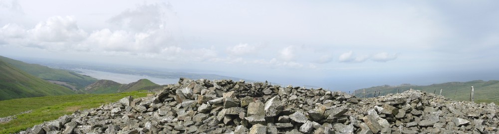
The Western Carneddau from Bethesda
From Bethesda to visit three cwms (Ffrydlas, Caseg and Llafar) with sheepfolds, Bronze Age cairns, prehistoric settlements, stock enclosures and abandoned homesteads. Winter.
Bethesda to Moel Faban and Cwm Fryddlas
Every journey has to start somewhere, and Bethesda, tiered on the eastern slope of the valley above the Afon Ogwen, is a good place to begin.Although a quarry town of the industrial era, named after the chapel founded in 1820, it is located at the point where the steep-sided main valley emerges from the mountains to form a widening flood plain leading to the Menai Straits. Thus it stands at the boundary between the lowland and upland environments; a favoured place for settlement [note 1].
The car park, perched just above the main road, was nearly empty. Snow lay above the 500m contour, and beyond the heaped spoil tips of the massive Penrhyn quarry, the big hills - Carnedd Dafydd, Yr Elen and the Glyders - stood like little Alps above the terraced rooftops.
I climbed up the steep streets to Cilfodan, along a track through semi-rural stone-walled fields, and soon reached the open grassy slopes of Moel Faban. Here a track bears left to flank the range, passing through extensive remains of early settlement and fields, on its way to Aber some three miles away, but I struck directly up for the top. At some 400m high, it is the north western outpost of the Carneddau, and is littered with remains of ancient settlement. The top is a wide, stony ridge on which there are a series of little stone heaps (probably modern), and also a line of three much larger Bronze Age cairns, some adapted as wind shelters [note 2].
The views from here are magnificent; directly north is the Conwy Bay whilst to the north west is the widening green plain where the Afon Ogwen meanders across to the Menai Straits at gloomy Penrhyn Castle, with Anglesey beyond. Looking inland towards the hills and my intended route, the promised lands of Cwm Caseg and Cwm Llafar lay out of sight, but immediately beside me was Cwm Ffrydlas, scarcely a mile long, yet a perfect, sheltered micro-territory with occupation dating from the Bronze Age to the Medieval period as well as more recent shepherding structures.
From the summit ridge of Moel Faban, just east of the second cairn the archaeological remains commence; a low stone wall coursing south east down the slope to join a complex of rectangular enclosure walls and circular huts on the gentle side of the valley, the outlines of which can be traced on the map. The main period of occupation appears to have been Iron Age and Roman although there are indications of Bronze Age activity as well as rectangular buildings of probable Medieval date [note 3].
On a rapid visit such as this its often difficult to make sense of complicated, denuded remains, but you can still get an impression of their situation and context. The busy-ness of the site, its complexity and the indications of cultivated fields gives the impression that this was a permanent settlement rather than a summer base, although the Medieval buildings may have been Hafodai .
Turning north east, up the marshy base of the valley looking for another important prehistoric settlement at the head of the cwm, I floundered happily along, distracting the wild ponies from their grazing. Just beyond the point where reedy tussocks give way to firmer grassland I began looking in earnest and after a few minutes I spotted some stones peeking from the turf, forming curving enclosure walls, merging with clusters of stone which formed several circular huts. Its simplicity suggests a single main period of occupation, possibly relatively short-lived although, as we know from other sites, appearances can be misleading, and there may be timber phases hidden beneath the turf. Close-by are two well-preserved small rectangular structures which may be Medieval hafodai, perhaps renovated and reused by later shepherds [note 4].
Although peat growth and other local environmental changes have occurred in many places, judging by the location of upland buildings and settlements, the transition from wet to dry ground nowadays often seems to have been the same in prehistoric times (Johnson 1978 130), and it is remarkable how true this is here. The builders of these later structures chose the same dry, sheltered niche as the prehistoric occupants, and probably also made use of the ready supply of building stone from their huts and walls.
Looking back down the valley, the whole of this little territory is visible; with the ridge of Moel Faban across the right hand side of the cwm (although the cairns seem to have been sited to be viewed from the coastal zone), and the lowlands opening up far below. I speculate that a little further up towards the pass beside Gryn might have been a good place for a hunting camp in the Mesolithic period.
Cutting south east across and back down the valley, I came across a simple oval sheepfold on a sheltered bank beside the Afon Ffrydlas (646681), partly banked with snow. Further across still are some trial quarry workings surrounded by bog which seeped freezing water over the top of my boots. Just beyond is a path which leaves the valley around the shoulder of Gyrn Wigau and threads through a little rocky gap. Here, filling the hidden cusp is a large sheepfold; an elaborate jumble of walls made up a several small cells and a larger enclosure linked by low apertures in the walls (644671). Looking down into the valley from this sheltered position you can clearly make out the boundary where the intensively divided lowland landscape peters out as it laps up against the more intractable terrain of the open moor.
Along the Afon Caseg
The path now heads east to enter the valley of the Afon Caseg, a two mile long corridor into the heart of the Carneddau massif. Contouring high along the northern side of the valley I soon joined the old quarry track which, although very eroded and flooded in places, provides an easy route into the cwm. After a mile or so I could look down to a large sheepfold near the valley bottom. In itself this is an important site, being one of the multicellular folds only found in this area. Probably of 18th century date, it consists of several small enclosures clustering on one side of a much larger fold. All the sheep commoning on the open hillside would be gathered together into the main chamber and then each shepherd would separate out his own sheep into a side enclosure.
This sheepfold also provides a convenient marker for a much more extensive and ancient site - a prehistoric settlement whose main outline can just about be made out from where I stand. Sited on steep and stony terrain on the northern side of the valley just above the boggy banks of the Afon Caseg, its walls are low, having been partially robbed for the fold. There are several 'wandering walls' and large curved enclosures with attached hut circles as well as some smaller circular 'stock pounds'. The impression is of a pastoral settlement, primarily for cattle, divided for use by a number of separate family groups rather than communally organised. Its location suggests to me that it was a summer grazing station for the farmers of the Ogwen valley, although year round occupation cannot be ruled out. No excavation has taken place here and the site is as yet undated, but a Late Bronze Age or Iron Age date is possible [note 5].
The quarry track curves round to the head of the valley, and here the snow is deep and soft. Beside the Afon Wen (a small tributary of the Caseg) on low and very wet ground is large multi-celled rectilinear sheepfold half-buried in snow which is still in use (673664). Behind the sheepfold are the steep mountain slopes, with the prominent craggy facet of Carreg y Gath holding centre-stage. Secreted directly below the crag is a hollow area occupied by a little marshy pool and two upright stones. Although these may be natural, this spot has the character of a place which might have been revered in prehistory (674659).
On the slightly higher, rocky ground to the left is a group of oval and rectilinear stock enclosures, and some simple shelters built around large boulders, probably dating from various periods in the last few hundred years old. In an early example of landscape archaeology, E. Owen provides valuable observational and ethnographic evidence for the function and date of the many abandoned folds, both large and small, encountered in the area:
'None of the buildings alluded to in this paper have been used in the memory of the oldest people. They cannot account for them. I have ascertained that lambs were formerly penned for the night.... It was likewise a custom to pen nightly newly-bought sheep until they became familiar with their walk.’ [this is the process referred to as hefting in the Lake District] ‘I have seen several of these pens, all of which are carelessly built, and are called Buarthau, with a former owner's name attached, or the name of a farm... A great number of sheep pens of a large size are to be seen along the hills unused and falling into decay.' (1867, 106)
Thus we learn not only that some of the simple oval enclosures may be 'Buarthau', but that even the substantial and well-preserved sheepfolds had fallen out of use by at least the early-mid 19th century - significantly earlier than might have been thought from the surviving condition of many of them.
This ground at the head of the valley is also a place where prehistoric settlement might be expected [note 6].
Cwm Caseg and Yr Elen
But there is a yet more hidden place beyond here, its presence betrayed by the Afon Caseg which tumbles through a narrow defile from the remote glen of Cwm Caseg, which curves steeply up and round for another half mile or so to reach the little-visited lake of Ffynnon Caseg. The snow was knee deep and there were no footprints to show me the easiest path. Slowly I beetled up into the heart of the cwm, the wet snow on the slopes of this great white amphitheatre lowering threateningly above me. All the remains beside the lake would be invisible today so I decided not to visit it. Instead, I traversed right onto the massive wedge formed by the north east ridge of Yr Elen, one of the 3,000ft mountains of the Carneddau, which must be climbed to gain the next great glen, Cwm Llafar.
Half-way up the ridge I made a seat in the snow and ate a late lunch washed down with warm tea. The clouds looked grey and heavy but were still high, and the sun pierced weakly through. The far-off coastal plain was hazily visible down and beyond the main valley and I could trace the dark thread of the Afon Caseg meandering along the wide, flat valley bottom, and the black line of the quarry track contouring its far side just at the snow-line. There are small quarry sites scattered along the length of the cwm, even on the high slopes above the head of the valley.
From my viewpoint I could now also look directly down to the high-tiered inner-sanctum of Cwm Caseg itself, with the snow-bounded lake showing deep black in its hollow. This may have been a special place in prehistory although the lake is perhaps too shallow to have attracted votive offerings. Above its northern shore are the foundations of a building interpreted as a late 18th century hafod which at 750m OD must surely be the highest such outpost in Snowdonia (678650, RCHMW 1956 137 site 488). This remarkable building is of farmhouse proportions (perhaps comparable with the extant building, now a mountain bothy high in Cwm Eigiau; see chapter X, and the ruined building in Cwm Clogwyn). There are small annexes to the main structure, and the remains of a large fireplace and hearth survive. This terrain must be sheep rather than cattle ground although the nearest folds I know of are some distance down the cwm (679657). Beyond even this point, tucked into the rocky slope at the end of the cwm is a group of three or four very small ruined rectangular or irregular structures, perhaps early shepherd's hafodai (c.676650).
For the next 500 ft to the top of Yr Elen, the ridge narrows and steepens, with glistening drifts of late spring snow glistening and thin sheets of ice crackling off the rock in the afternoon sun. Most walkers visit here from the gentle ridge which links it to Carnedd Llewelyn, the highest peak in the Carneddau, but in so doing they miss this rugged and remote facet which can be best appreciated from Gwaun y Garnedd to the east. As expected I had the top, a flattish open area, to myself. Strangely there doesn't seem to be a prehistoric cairn here although it is the most prominent peak of the range as seen from the lower Ogwen valley [note 7].
Down into Cwm Llafar
From the summit I began the return journey to Bethesda by heading north west down Foel Ganol, the broad shoulder of the mountain which overlooks Cwm Llafar, feeling my way with my ice axe, but still occasionally stumbling on rocks hidden below the level snow-crust. The topography of this cwm can be clearly seen from here; the near side slopes and shelves relatively gently to its narrow floor, in stark contrast to the far side where a glorious cascade of crags, boulders, spurs and runnels spills down from the ridge of Mynydd Ddu.
At Cwmglas, the head of the valley a mile further up, are the dark intimidating cliffs of Ysgolion Duon, the Black Ladders which rise 1500 ft above the waterlogged floor of the glen. In Cwmglas Bach, a little below here a fascinating collection of labyrinthine small sheep folds and shepherd's hafodai are to be found, well described by Owen:
'...the entrance to Cwmglas, is covered with immense masses of rock riven from the sides of the precipice above. A huge piece of fallen rock lying on the ground like an inverted chair, has the space underneath enclosed, and forms a pen called Buarth-tan-yr-ogo. There are numerous remains of buildings in this spot, generally oblong and isolated...nothing like a chimney could be found in any of them; but in other places, where similar remains exist, chimneys have been found, and small recesses in the walls, in which a few things could have been deposited'. (1867 104-5) (vicinity of 665637).
A little further down is a cairn-like heap of stones on a low belvedere beside Nant Moch (c.662643).
Leaving the snow-line behind, I crossed a slope of very bouldery and then boggy ground above the base of the valley. Owen records a concentration of abandoned structures in this area:
'Along the side of a stony ridge in this cwm, called Argoed, no less than twenty-six such buildings may be seen, of various forms and sizes. The whole of the Argoed is covered with drift-stones; and to get at these buildings is somewhat difficult as large stones have to be scrambled over.' (1867 104).
Despite the unpromising terrain this is a classic favoured settlement locus. The remains appear to include archetypal Medieval hafodai sitting beside little streams, and several small sub-rectangular folds and shepherds hafodai, probably of later date. Some determined hunting around also discloses the remains of at least one large stock-pound on steep stony ground which is potentially prehistoric (similar to those at Pant y Griafolen; Chapter x), and some possible hut circles. Topographically this site is broadly equivalent to the well-known prehistoric site on the side of Cwm Caseg described above, and I speculate that camouflaged in this stony terrain is a parallel settlement complex (area of 659648, several of the structures are marked on the OS map) [note 8].
Following the Afon Llafar down the cwm I soon leave the bleak mountain terrain behind for the more open, fresher ground of the upland fringe which widens its aspect towards Bethesda. This is a terrain abundant with remains. On the left, just over the nearby flank of Mynydd Ddu is the small valley of the Afon Cenllusug (Stream of the Hailstones), home to a prehistoric settlement made up of several round houses linked to three or four low drystone enclosures sited on a belt of very rough stony pasture below steeper and impossibly bouldery terrain but not far from the boggy banks of the stream. Its presence fits a pattern of each major valley catchment in this area having a prehistoric site at between 400-500m. To our eyes its an unattractive place but it was clearly another persistent place, as close-by on the uphill side are several small rectangular ruins, perhaps Medieval hafodai with later reuse [note 9].
Returning out attention to the main valley, the Afon Llafar is flanked by sheep-pens and -dips on both banks of the stream; one is of the large cellular variety whilst another is a simple enclosure consisting of large natural boulders linked by stretches of walling, appearing almost as an outgrowth from the natural landscape. For centuries this was probably a favoured area for gathering sheep from the mountain pastures and washing them prior to shearing [note 10].
Continuing downstream a well-maintained 18th or 19th century drystone wall is soon reached. On the map this can be seen to contour in a rough semi-circle around the slopes above Bethesda, delimiting a formal boundary between upland and lowland. I crossed back onto the east side of the stream, and from here the path moves through a thickly textured landscape of fences, overgrown enclosure walls, sheepfolds, abandoned homesteads, stumpy hawthorn scrub, and eventually, a stone-revetted droveway. Despite the intensity of past useage this is very poor ground, with jumbled boulders too large to shift, perched on thin waterlogged turf and bog.
The ground becomes deeply churned and muddy as I approached the yard of Gwaun y Gwiail where I met the reality of a hard-pressed hill farm emerging from winter - flapping plastic bags, debitage, and the forlorn soggy corpses of several sheep recovered from the mountain. From here the road drops down to Gerlan, with residents cars parked in every gap and opening, and then to Bethesda, my heavy winter boots dragging on the tarmac with every step.
Note 1: Attesting to the significance of the area in antiquity is the Neolithic chambered tomb of Bryn Eglwys on the far side of the river a mile to the west, and the small hillfort of Pen-Y-Gaer set back from but overlooking the Ogwen valley (628672, RCHMW 1956, 138 site 491.]
Note 2: Settlement on the slopes in the area of NGR 637690 (see Crew and Musson 1996, 20. For the summit cairn see RCHMW 1956 151 site 554].
Note 3: Moel Faban: NGR 636678. Griffiths 1950, 44, Lynch 1995 92-4, with plan. Clearly shown on 1:25000 map but difficult to find on the ground. RCHMW 1956 145-6, site 519].
Note 4: Cwm Ffrydlas: NGR 644 684 Griffiths 1950, 45-7 with plans, Lynch 1995, 45, with plan. Lynch et al 2000 91-2, plan p88, RCHMW 1956 144-5, site 516]. The basic plan can be made out on the 1:25000 map. Tricky to locate. Although possibly Early Bronze Age, it may be Late Bronze Age/Iron Age. The rectangular structures are recorded in RCHMW 1956 15-01, one is named as Hafotty Lowri, 645685, standing to 2m, site 549. Both appear on the 1:25,000 map],
Note 5: 659669. For plan of sheepfold see RCHMW 1956 lxxvii, for the prehistoric site see ibid. 139-40 site 492, Griffiths 1950 48 with plan, Crew and Musson 1996, 42 with aerial photo and plan. Detailed on 1:25000 map.]
Note 6: I found none here although there is an apparently isolated small round hut, undoubtedly a hafod, 250 metres to the south west on boggy ground on the far side of Afon Caseg (c.674657)].
Note 7: Unlike its higher neighbours - Llewelyn, which has a small cairn now hollowed as a shelter, and Carnedd Dafyyd which has a massive, possibly Neolithic, cairn.
Note 8: higher up on the steep moors to the east is a wonderfully remote Medieval or later hafod site beside a now-dry stream consisting of two well-preserved small huts and archaeological indications of at least one other cut into the slope on the other side of the stream (667648, shown on OS map).
Note 9: prehistoric site shown on 1:25,000 map at 649648, RCHMW 1956 140 site 493. Adjacent site at 648651, recorded as longhut and enclosure in RCHMW 1956 150 site 542].
Note 10: Area of 649654, some sites marked on 1:25,000 map. A plan of the cellular fold is in RCHMW 1956 lxxvii. Also noted in this source are a long hut and oval enclosure, probably a sheepfold at 649653 (ibid. 150, site 546)]
See here for contents page, or here for the bibliography.
Note: This is part of an original series of articles written by archaeologist M M Robinson.


 We would like to know more about this location. Please feel free to add a brief description and any relevant information in your own language.
 Wir möchten mehr über diese Stätte erfahren. Bitte zögern Sie nicht, eine kurze Beschreibung und relevante Informationen in Deutsch hinzuzufügen.
 Nous aimerions en savoir encore un peu sur les lieux. S'il vous plaît n'hesitez pas à ajouter une courte description et tous les renseignements pertinents dans votre propre langue.
 Quisieramos informarnos un poco más de las lugares. No dude en añadir una breve descripción y otros datos relevantes en su propio idioma.