


Abandoned Landscapes - The Northern Carneddau from Aber
Submitted by M_M_Robinson on Thursday, 20 July 2006 Page Views: 14814
Multi-periodCountry: Wales
The Northern Carneddau from Aber
Visiting the valley of the Afon Anafon, rich in remains of several periods; crossing the watershed into Cwm yr Afon Goch; a wretched night camping high in the cwm, more sites along the valley, and then west along old routeways to skirt around Moel Wnion back to the historic village of Aber. September.
From Aber into Cwm Anafon
The A55 dual carriageway streamed with a mesmerising onrush of traffic on this last Saturday before the school term begins. The dangerously short slip-road to Aber suddenly flings you from the current onto a tranquil stub of the old coast road where I park the car. The village has probably changed little in form since Fenton described it nearly 200 years ago as being 'most pleasingly situated at the entrance into a charming romantick little Valley, with a scattered village and Church prettily sprinkled with trees.' (Fenton 1917, 207-8). There has since been some infilling but its scale and character is intact.
Looking at the deeper structure of this location we see that it lies at the juncture of the narrow coastal plain and the extensive upland tracts penetrated by the Afon Anafon and Afon Goch. In addition, it forms the gateway to the main traditional routeway across the hills to the Conwy valley. These two geographical elements have made it something of a historical nodal point. Thus it is no surprise that there is a hillfort, Maes y Gaer, perched high on the valley shoulder overlooking coastland, valley and routeway. Aber itself, sited in the very mouth of the valley was also a centre of elite power. The remains of the motte and bailey can still be seen, and the village is famous as an administrative base of the kings of Gwynedd (Davies 1993, 159-60). Remains of a stone-founded building 26 x 10m were excavated in 1993 in the field adjacent to the motte. This has been interpreted as the main hall of the Llys (or royal court complex) (Johnstone 1997 63-5) [note 1].
However, its the rich archaeology of the hidden hinterland in the valleys and mountains behind the village which form the subject of this journey (the ancient routeway across the hills will be explored more fully in a later chapter).
The houses end abruptly and the road narrows and begins to climb alongside the Afon Aber through bracken-carpeted woods of sycamore, oak and ash. Across the valley in the distance Maes y Gaer is visible only as a bald treeless patch above forested crags, although in its prime its ramparts would have been unmistakable (664725). There were dozens of cars and a park ranger's landrover in the car park at Bont Newedd but no-one was about.
Here the valley splits two ways; most people will head straight ahead towards the Aber waterfall which cascades down from the high remote valley of the Afon Goch, but our route goes left at the bridge to follow the narrow hill road which twists up the side of the Anafon valley, more or less following the course of the ancient road towards Bwlch y Ddeufaen and the Conwy valley.
This stretch of walking is marred by the power cables which clamber down from the bwlch, buzzing and crackling in the dew-laden air as they pass low overhead and then launch into space across the wide valley in one daring, drooping sweep. The road continues through broad sloping fields, mounded with clearance cairns in places and then comes to a full stop below the steep scree slopes of Foel Duarth.
A grassy way beside a drystone wall takes us into Cwm Anafon. Down a narrow path on the right is a jumble of abandoned buildings - a small ramshackle corrugated iron structure, a roofless one-roomed cottage and a shed. Looking more closely I noticed the remains of a chimney seeming to belong to an earlier building now overgrown. Most people wouldn't give this place a second glance but this is the site of Hafod-y-gelyn, the hafod of the Prince's manor at Aber. Remains of the Medieval site have been found but the current buildings apparently date from the 18th century, perhaps at a time when the hafod was converted to a smallholding (see Davies 1979 24). In Fenton's time its was 'an old house in ruins, with a small farm house close to it' (Fenton 206). Nowadays it seems to only be in marginal use, perhaps for storage, and is not maintained. We can tell that the site is in a favoured micro-environment because leading from the holding down towards the stream are two large fields green with a crop of kale. All this however, is only the tail-end of a much longer sequence of usage, attested by the extensive prehistoric settlement, houses, fields and cairns recorded in the immediate vicinity (area of 676714, RCHMW 1956, 10-13).
Beyond Hafod-y-gelyn are another two miles of wild valley containing a succession of sites, many of which I would argue were also seasonal. Most lie close to the stream on pathless rough ground, well below the made-track to the reservoir used by walkers venturing here. The first site I found, at an obvious crossing point of the stream, was an oval sheep pound made of large stones (c.679710). Next was a beautiful cellular sheepfold consisting of a central enclosure with several smaller chambers leading off it - some rectangular, some oval - with little low openings leading from one chamber to the other. Some rushes grow inside but it looks as if it was used until recently (682711). The map marks some hut circles nearby and I beat back and forth through the deep bracken searching for them under the curious gaze of two walkers on the track above. Eventually I located them on a flat area close to the stream edge - a couple of rough circles of large stones 7-8m across with slight central depressions (684712, Bezant Lowe 1912, 115-6).
Half a mile further on are two oval drystone enclosures, 10-15m across set 20m back from stream, and on the other side is a cleared grassy area apparently revetted with stones. The most visible monument hereabouts is another large sheepfold, probably the finest I've seen. Its exo-skeleton has been cleverly formed by utilising huge natural boulders connected by drystone walling. There are metal pintles for a gate on the entrance into main chamber and on the ground there are placed-stones suggestive of now-lost features for controlling or dividing the animals. From here you can peek through the little openings into the smaller chambers although some have collapsed and others have been deliberately blocked. In the centre is a patch of burnt turf where someone has recently made a campfire. This is a complex multi-phase monument and its detailed study, including excavation, would be very illuminating (689710).
The map marks a continuing string of sites along the banks of the stream as it winds upwards. Two cairns are shown on the northern side not far from a prehistoric incised stone. I failed to notice any of them on the bracken-covered slopes (689712 and c.693710), but couldn't miss another round house, 10m across and well over a metre high. Tucked in the back under one of the stones was a Mitchells and Butler beer bottle dated 1962 along with some corroded beer can fragments - good dating evidence for a more recent episode of usage. I carefully placed the bottle back in its context (c.694708).
I sat for a few minutes beside the stream in the shelter of an earth bank of indeterminate shape and age. Downstream the big sheepfold was still visible, with sheep grazing beside it, and beyond the valley curved away out of sight. On the slopes around me the green and brown vegetation was patched with purple heather. Above a pair of raptors silently quartered their home-ground.
The terrain alongside the watercourse becomes too broken to follow so I struggled up the steep bracken slope to join the reservoir track. A beautifully-preserved Medieval or Post-Medieval longhut lies adjacent to track. Set slightly into the slope it measures about 10m x 5m. and survives to over a metre high. About 2/3rds of the way down one of its long sides is an entrance, whilst inside is a cross-wall forming a small room with a small platform within it. From here I can see the corner of another building sticking up amongst reeds near the stream - another longhut parallel with the stream, larger (about 10m x 10m) and made of bigger stones. 100m further on between the track and the stream is a scatter of stones which looks as if it could be two round houses with an associated wall (possibly the site marked as a hut circle on the map at c.696706). Further on again and this time just to the left of the track, overgrown with rushes, is a two-celled structure; the nearest cell is rectangular whilst the one behind is oval, probably a shepherd's shelter with an attached fold (699704).
Although the concentration of sites along the cwm seems to suggest intensive usage, the visible monuments are only faint indeterminate blips spanning 40 centuries or more. The incised stone and the cairns are probably the oldest features (presumably Early Bronze Age). In such a valley location I would expect the cairns to be close to settlement (indeed the cairns may have been deliberately built on house sites). The visible round houses are probably later and may be as late as the Romano-British period. Whether their use spanned 50 years or 1000 years we just don't know. The 18th/19th century sheep economy is represented by the big sheepfolds. The various smaller enclosures and rectangular buildings sit somewhere inbetween - Medieval and Post Medieval hafodai for herdsmen and shepherds, whilst some of the several oval enclosures were perhaps hefting folds.
On the approach to the head of the cwm the outflow from Llyn Anafon comes into view below the small dam. Running mid-way between the reservoir track and the stream is an excellent 30m stretch of holloway with earth and stone banks on each side, presumably remnants of an earlier stock trail. Where the made track turns sharp right towards the Llyn I think I can make out the vestiges of the older route going straight across the rough ground. Immediately below the reservoir outflow are some small shacks, presumably connected with its construction and maintenance.
Over the watershed into Cwm Yr Afon Goch
Like many of the upland llyns this is a sombre place and I felt alone and exposed; any other walkers had long gone home. To gain the next valley I had to climb up and over Llwytmor from where cloud was pouring from the high ground like a weightless avalanche. Because of the foot and mouth plague I hadn't been to the hills seriously for many months and the prospect of climbing into unknown terrain in the evening mist was daunting. Taking a compass bearing from the map I struck a more or less direct course up its steep undulating grassy slopes.
Half way up I turned around and caught a moment of great clarity as light shimmered off the distant surface of the lake above which a buzzard circled; beyond it the valley wove into the horizon, shadowed above by the long ridge of Drum. Then I was in the swirling cloud on the vague and shapeless open moor, splashing through peat hags and bog, everything close, alive and in focus. Not far off the 700m contour I spotted an irregular sheep enclosure, amongst the highest in these hills (c. 695696). Gradually the ground got tougher, with rock outcrops - carnedds - looming through the haze - I'd passed from mild autumn, through the back of the wardrobe, into the cold blustering drizzle of winter. On the watershed I sheltered beside one of the rock-jumbles and put on more clothing. If I went wrong here I'd end up blind and lost on this high ground, so I checked and rechecked my course till my hands and brain began to get numb, and heading due west hoping that when I dropped below the cloud I would be in the head of Cwm yr Afon Goch.
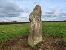
Part way down the slope a massive finger-like block took shape out of the mist, jutting like a tombstone from surrounding jagged rocks. And a few yards below, lying on the wet uneven turf I saw what for an instant looked like a heap of bones from a huge creature. But getting close I see that its metal scrap from a wrecked aircraft - rods and poles, twisted, undercarriage, ripped riveted metal skin and hydraulic pipes in small forlorn heaps. I think of an elephant graveyard - a large piece of bent sheet-metal with a round hole looks like part of a huge eye-socketed skull, the other debris like disarticulated tusks, ribs and limb bones. Best to leave this wreckage here untouched, at the foot of its grim marker stone. There are over 100 crash sites from this period but this is one of only a couple I've personally come across. I read later that this is the wreckage of a Blackburn Botha, a Second World War aircraft with a crew of four used for reconnaissance and torpedo bombing (683694). Its brief epitaph in Doylerush's definitive book on aircrashes in Snowdonia makes bleak reading:
'20-7-42. Hit the west face of Llwydmor in cloud. No survivors.' (Doylerush 1985, 91)
Rain began to fall as I dropped below the cloud level and I put up my umbrella. Hills and horizon were invisible but thankfully, arrayed below was the lonely valley Cwm yr Afon Goch twisting and winding down. Slipping and slowly stumbling over rocks and outcrops I reached the stream and filled up my waterbottle near some little waterfalls. The rain now fell heavily as I wandered backwards and forwards indecisively looking for a sheltered site, and I was drenched by the time I managed to set the tent. Then as I stretched out inside, a growling gust of wind rolled down from Foel-fras, scouring the valley and tugging determinedly at the tent pegs. After eating I poured out some spirit from my flask and added a little water. The mix of whisky and mountain water made me nauseous and my heart pounded erratically. A heavy mist soaked down the hillsides muffling every nook and curve of the valley, and I lay half-awake on the hard sloping ground while the wind and rain thrashed at the tent fabric throughout the interminable night.
At 8.00 am. I managed to shake off the darkness, sit up, light the stove and force down hot cereal. It was a wet and cold start to the day and mist still covered the tops but it was clear down the deeply incised and rugged cwm. Following intermittent and misleading pathways, after less than a mile the rocky terrain calmed, the aspect widened and the sea came distantly into view. I was reaching the high-water mark of human occupation; alongside the stream as it descends from here to the top of Aber Falls are several structures and small settlements, most of which must have been hafodai of one kind or another.
30m from the stream there was a small pile of stones peeking out of the turf with overgrown humps and bumps adjacent, probably prehistoric (c.673694) [note 2]. Another 200m further along, a line of large stones possibly from a relict boundary wall crosses the track, followed by a round house on a slightly raised area. Next is one of the large cellular sheepfolds. Inside the entrance to the main compartment is a double line of stones, presumably the remnants of a stockade for separating stock, hinting at the elaboration and complexity of these wonderful constructions (671696). Immediately downstream is an area of flattish turf with a rough retaining wall where it drops to the stream. On the southern side, built into the slope is a thick-walled round house10m across and over 2m high, utilising some large boulders as well as smaller stones. At least two others can be seen nearby (marked as 'Settlement' at 671696 on the map. See also RCHMW 1956, 7).
A hundred metres beyond, beside the path, are two massive boulders to which rough walling has been added to create a small rectangular shelter about 8m x 5m, but actually very small inside. Adjacent are indications of walling between the stream and the steep valley side, apparently part of a related enclosure. Such lean-to's are dotted around the hills of North Wales frequently associated with small pens. They are usually in very poor condition and although they could be of varying date and purpose I think they are perhaps early shepherd's shelters from the time of Medieval or Post-Medieval transhumance and prior to the commercialisation of sheep production from the 18th century.
Around the slopes of Drosgyl, Gryn and Moel Wnion
The top of Aber Falls is only a few hundred metres further down the cwm but my plan was to explore the lands to the west, around Gryn and Moel Wnion. This meant retracing my steps back to the sheepfold and fording the ice-cold Afon Goch. The track cuts diagonally up the side of the valley at an easy angle and soon I had a bird's eye view of the sites I'd just visited - the sheepfold and the prehistoric settlement. Also, on flattish ground on this side of the cwm is a site shown on the map; a curved compound with a rectangular foundation attached with a possible round house close-by (669697).
Reaching the high-tiered shoulder of ground overlooking Cwm Aber I find a ring of stones 9-10m across, slightly cut into the slope. 40m downslope is another heap of stones (these are part of a scattered group of round huts, marked as 'Settlement' on the map at 667697, and see RCHMW 1956 8). The view from here is tremendous; in the lush valley the trees cluster along the edges of the meandering river, fringed by pasture and bracken, bright green with wetness. Above Aber stands the hillfort, Maes y Gaer, clear of trees, and with the eye of faith I can make out the lines of its rampart. The left horizon is taken by Moel Wnion, less than 600m high but of great bulk stretching nearly 2 miles towards the flat sheen of the sea in Conwy Bay.
Recent intensive survey of Cwm Aber has identified nearly 100 new sites, showing that late prehistoric/Romano-British settlement concentrated around the head of the valley along with considerable evidence for mixed farming interpreted as permanent sites at the interface between lowland and upland zones. Medieval remains include indications of cultivation and several hafod sites. The conclusion was that 'through history the valley has supported significant populations of people engaged in mixed subsistence economies entailing the summer grazing of cattle on upland pastures accompanied by the cultivation of hay as well as various hardy arable crops on a small scale' (Roberts 2001, quote 96).]
Continuing west across the face of the hill I reached the minor cwm of Afon Rhaeadr-bach where there is a fine rectangular sheepfold on a flattish area 50m above the stream. Its about 10m wide, 20m long and full of reeds. Unusually it has associated enclosure walls, together forming quite an extensive complex. From here there is a worn trackway edged with stones, leading down to a boggy, eroded crossing-point/washpool. The trail then climbs gently south west along the lower slopes of Drosgyl towards Gryn.
This area has seen much travel and stock movement onto, off and across the high ground over the centuries, etching trails into landscape. From the slopes I could see three making towards Cwm Aber, one of which traverses the east side of Moel Wnion whilst the other two zig zag down more directly into the valley. A large stone sits in one hollow, possibly as a route marker. My route followed a clear green-way grazed by occasional sheep and wild ponies, but as I ascended through the mist-line it petered out onto bleak featureless moor. In the penetrating cold drizzle I followed a compass bearing and surprisingly quickly reached the important route node on the wide plateau where several pathways across the north east Carneddau converge (653690). This is a crossing point between Cwm Aber and the Ogwen valley and also a packhorse route south east up into the high hills and thence down to the Conwy valley 8 miles away. The head of Cwm Ffrydlas is only a few minutes walk to the south west (see previous chapter).
The fog wafted clear for a few seconds revealing the strange conical mound of Gryn close on my left. In the lee of this hill is an area like a small football pitch, cleared of stones and enclosed by a disused post-and rail fence. Behind it is a large sheepfold complex with walls up to two metres high looking as if its still in use. This is probably the largest upland fold in North Wales and I imagine this is to do with its central location on extensive common uplands, accessible to farmers from a wide sweep of lower ground from the north to the south west. Thus large numbers of sheep could have been gathered here for allocation to many different owners.
There are several small slate-fenced compounds attached to the fold - one or two had sheep closed in them. Nearby were a couple of large cattle long-bones lying in the turf - sheep bones are common but cattle remains are more unusual - and a few yards away through the murk I found the decomposing carcass of a cow, its liquefying adipose tissue leaving a black slimy puddle on the dead grass.
Now my path took me north west along the packhorse route with the intention of circumnavigating Moel Wnion back to Aber. Descending the hillside out from the mist I saw a lake and a white farmhouse in the near distance - the first habitation since leaving Bont Newedd at the start of the walk.
Further away Bangor and Penryn Castle were visible on the coast through the light haze. The hillslope on my left holds an important archaeological landscape, being the final knot in a continuous string of abandoned upland settlement commencing at Moel Faban a kilometre to the south (see previous chapter). The ground looks fairly unattractive - rough moorland and bog - but the unmistakable remains of ancient fields, terraces, house foundations, circular and rectangular enclosures, stock pounds and trackways are visible here (c.632685, and see RCHMW 1956 14043, sites 494-508.
Worn tracks and pathways seem to come and go from every direction, but I managed to find the route curving along the western slopes of cloud-sheathed Moel Wnion. This is pleasant walking on open turf dotted with gorse and hawthorn. Many sheep graze here and lower down cattle chew the cud in the enclosed fields. This must have been a well-used passage between the Ogwen valley and Aber but it is not worn at all. However, every 50m or so small piles of stone have been placed as route-markers. It is difficult to date such features; hillwalkers will be familiar with modern ones on mountain paths but they are not usual on low moorland routes such as this. However, these look well bedded-in and could be of some antiquity.
The path dips across a couple of small streams and soon I could see and hear the A5 traffic on the flat coastal strip. There are other remains to visit higher up the slope here but all enthusiasm was gone as I plodded slowly onwards [note 3]. Eventually the final steep eroded footpath above Aber is reached, offering the finest prospect of the village.
Note 1: The motte (Pen-y-bryn) is described in RCHMW 1956, 6. The hillfort (663725) has steep slopes on all sides except to the east, and is enclosed by a single stone rampart indicative of an early date (RCHMW 1956, 6-7)
Note 2: RCHMW 1956, 7 records an extensive group of enclosures, huts and nearby fields at 673693. I should have been more observant.
Note 3: On the northern and eastern slopes of Moel Wnion are extensive remains of prehistoric and Medieval settlement in the form of round houses, cairns, rectangular huts and terraced field systems (RCHMW 1956 8-10); Roberts 2001).
See here for contents page, or here for the bibliography.
Note: This is part of an original series of articles written by archaeologist M M Robinson.


 We would like to know more about this location. Please feel free to add a brief description and any relevant information in your own language.
 Wir möchten mehr über diese Stätte erfahren. Bitte zögern Sie nicht, eine kurze Beschreibung und relevante Informationen in Deutsch hinzuzufügen.
 Nous aimerions en savoir encore un peu sur les lieux. S'il vous plaît n'hesitez pas à ajouter une courte description et tous les renseignements pertinents dans votre propre langue.
 Quisieramos informarnos un poco más de las lugares. No dude en añadir una breve descripción y otros datos relevantes en su propio idioma.