<< Our Photo Pages >> Big Moor Cairn Field - Barrow Cemetery in England in Derbyshire
Submitted by dooclay on Wednesday, 01 March 2023 Page Views: 585
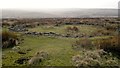
Neolithic and Bronze AgeSite Name: Big Moor Cairn Field Alternative Name: Barbrook Cairn FieldCountry: England County: Derbyshire Type: Barrow Cemetery
Nearest Village: Froggatt
Map Ref: SK278757
Latitude: 53.277557N Longitude: 1.58455W
Condition:
| 5 | Perfect |
| 4 | Almost Perfect |
| 3 | Reasonable but with some damage |
| 2 | Ruined but still recognisable as an ancient site |
| 1 | Pretty much destroyed, possibly visible as crop marks |
| 0 | No data. |
| -1 | Completely destroyed |
| 5 | Superb |
| 4 | Good |
| 3 | Ordinary |
| 2 | Not Good |
| 1 | Awful |
| 0 | No data. |
| 5 | Can be driven to, probably with disabled access |
| 4 | Short walk on a footpath |
| 3 | Requiring a bit more of a walk |
| 2 | A long walk |
| 1 | In the middle of nowhere, a nightmare to find |
| 0 | No data. |
| 5 | co-ordinates taken by GPS or official recorded co-ordinates |
| 4 | co-ordinates scaled from a detailed map |
| 3 | co-ordinates scaled from a bad map |
| 2 | co-ordinates of the nearest village |
| 1 | co-ordinates of the nearest town |
| 0 | no data |
Internal Links:
External Links:
")
Ramsley Moor, Barrow 9
Ramsley Moor, Barrow 7
and more generally, Big Moor and Ramsley Moor: Settlement & Burial cairns.
This last comprises a variable number of Cairns over a large area: Sixty-seven cairns [numbered and plotted on 25" from map in 1] on Ramsley Moor adjoining Barbrook. They comprise:- 4 large mounds 30-35 ft. across. 13 medium-sized mounds 20 to 29 ft. across. 50 small mounds below 20 ft. across.
Source: from the Derbyshiire HER
I found a line of 8 Cairns between Barbrook Cairn at SK27917561 and Barbrook 2 Circle at SK27757582.
An enlargement of the Megalithic Portals Interactive OS map shows their locations.
You may be viewing yesterday's version of this page. To see the most up to date information please register for a free account.
")
")
")
Do not use the above information on other web sites or publications without permission of the contributor.
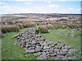
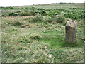
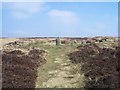
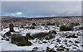
Nearby Images from Geograph Britain and Ireland:
©2005(licence)
©2013(licence)
©2009(licence)
©2018(licence)
©2012(licence)
The above images may not be of the site on this page, they are loaded from Geograph.
Please Submit an Image of this site or go out and take one for us!
Click here to see more info for this site
Nearby sites
Key: Red: member's photo, Blue: 3rd party photo, Yellow: other image, Green: no photo - please go there and take one, Grey: site destroyed
Download sites to:
KML (Google Earth)
GPX (GPS waypoints)
CSV (Garmin/Navman)
CSV (Excel)
To unlock full downloads you need to sign up as a Contributory Member. Otherwise downloads are limited to 50 sites.
Turn off the page maps and other distractions
Nearby sites listing. In the following links * = Image available
130m SSE 158° Barbrook 1* Stone Circle (SK27857558)
130m NNW 338° Barbrook 2* Stone Circle (SK27757582)
142m SE 130° Barbrook cairn* Cairn (SK27917561)
188m WSW 238° Barbrook Cupmarked Stone* Standing Stone (Menhir) (SK27647560)
237m WNW 293° Big Moor Cairns SW* Barrow Cemetery (SK27587579)
424m SW 225° Big Moor* Ancient Village or Settlement (SK275754)
921m SW 221° Swine Sty* Ancient Village or Settlement (SK272750)
941m WSW 238° Barbrook 5* Ring Cairn (SK270752)
1.2km E 94° Barbrook 4* Ring Cairn (SK2896375621)
1.7km NNE 19° Barbrook 3* Stone Circle (SK28337728)
2.1km NNW 334° White Edge Cairn* Cairn (SK26847762)
2.2km NNW 336° The Hurkling Stone* Marker Stone (SK269777)
2.3km SSE 163° Birchen Edge 1* Ring Cairn (SK285735)
2.4km S 185° Gardoms Edge 2 (Baslow)* Rock Art (SK2761773339)
2.4km S 190° Gardoms Edge Cairns* Barrow Cemetery (SK27407330)
2.4km S 187° Gardoms Edge 02 (Baslow) Rock Art (SK27527328)
2.5km SSW 193° Gardoms Edge Stone* Standing Stone (Menhir) (SK2725273225)
2.6km SSW 195° Gardoms Edge Enclosure* Causewayed Enclosure (SK2716473201)
2.6km NNE 30° Owler Bar Cairn (SK291780)
2.7km SSW 191° Gardoms Edge 1* Rock Art (SK2728573037)
3.0km SSW 193° Three Men of Gardoms* Round Barrow(s) (SK2716172774)
3.0km WNW 291° Stoke Flat* Stone Circle (SK24967679)
3.2km S 173° Birchen Edge Stone* Natural Stone / Erratic / Other Natural Feature (SK28207256)
3.3km S 187° Gardoms Edge Ringcairn* Ring Cairn (SK274724)
3.3km S 173° Birchen Edge 2 Ring Cairn (SK282724)
View more nearby sites and additional images


 We would like to know more about this location. Please feel free to add a brief description and any relevant information in your own language.
 Wir möchten mehr über diese Stätte erfahren. Bitte zögern Sie nicht, eine kurze Beschreibung und relevante Informationen in Deutsch hinzuzufügen.
 Nous aimerions en savoir encore un peu sur les lieux. S'il vous plaît n'hesitez pas à ajouter une courte description et tous les renseignements pertinents dans votre propre langue.
 Quisieramos informarnos un poco más de las lugares. No dude en añadir una breve descripción y otros datos relevantes en su propio idioma.