


<< Other Photo Pages >> Calling Low Dale - Cave or Rock Shelter in England in Derbyshire
Submitted by Andy B on Wednesday, 18 September 2002 Page Views: 7938
Natural PlacesSite Name: Calling Low DaleCountry: England County: Derbyshire Type: Cave or Rock Shelter
Nearest Town: Bakewell Nearest Village: Youlgreave
Map Ref: SK184654 Landranger Map Number: 119
Latitude: 53.185380N Longitude: 1.726108W
Condition:
| 5 | Perfect |
| 4 | Almost Perfect |
| 3 | Reasonable but with some damage |
| 2 | Ruined but still recognisable as an ancient site |
| 1 | Pretty much destroyed, possibly visible as crop marks |
| 0 | No data. |
| -1 | Completely destroyed |
| 5 | Superb |
| 4 | Good |
| 3 | Ordinary |
| 2 | Not Good |
| 1 | Awful |
| 0 | No data. |
| 5 | Can be driven to, probably with disabled access |
| 4 | Short walk on a footpath |
| 3 | Requiring a bit more of a walk |
| 2 | A long walk |
| 1 | In the middle of nowhere, a nightmare to find |
| 0 | No data. |
| 5 | co-ordinates taken by GPS or official recorded co-ordinates |
| 4 | co-ordinates scaled from a detailed map |
| 3 | co-ordinates scaled from a bad map |
| 2 | co-ordinates of the nearest village |
| 1 | co-ordinates of the nearest town |
| 0 | no data |
Internal Links:
External Links:
I have visited· I would like to visit
PAB has visited here
")
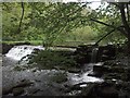
Photos provided by Alexis Lambourne, who writes that "The cave / shelter makes use of a natural overhang in the cliff which makes a roof, this has been added to by enclosing it with a dry stone wall. The enclosed space is small (~6 ft long and maybe 4 feet wide). It is dry-ish, but the strata of the limestone rock just there is vertical making the roof quite loose and a bit drippy. Definitely more of a shelter than a 'home'. "
The Pastcape link provided by coldrum describes the 2 cists found in excavations in the 1930s. One contained a crouched female inhumation, the skull apparently pierced by a sharp weapon at the front. The other cist was filled with a fine soil which contained a quantity of human bones and sherds from two Peterborough Ware bowls. Full details are on Pastscape - well worth a read.... At least some finds from the site (including the surviving Peterborough Ware bowl) are stated by Pastscape to be in Sheffield City Museum.
Access is difficult, across some fields to get from the limestone way into the top of Calling Low Dale. However navigation is easy - just follow the wall line north out of Bee Low Wood. There are a couple of fences to hop over at the top of Calling Low Dale and then you go down the steep, narrow, overgrown dale to the shelter. Exit from Calling Low Dale should be made the same way as you went in (south to the limestone way). Progress into Lathkill dale is slow, steep, slippy and overgrown - Calling Low Dale also brings you out ~1km from the closest foot bridge over the river Lathkill, and getting along Lathkill Dale to the bridge is very hard work due to dense undergrowth!
You may be viewing yesterday's version of this page. To see the most up to date information please register for a free account.
")
")
")
Do not use the above information on other web sites or publications without permission of the contributor.
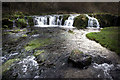
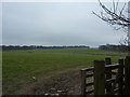
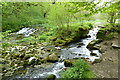
Nearby Images from Geograph Britain and Ireland:
©2005(licence)
©2010(licence)

©2010(licence)
©2023(licence)
©2007(licence)
The above images may not be of the site on this page, they are loaded from Geograph.
Please Submit an Image of this site or go out and take one for us!
Click here to see more info for this site
Nearby sites
Key: Red: member's photo, Blue: 3rd party photo, Yellow: other image, Green: no photo - please go there and take one, Grey: site destroyed
Download sites to:
KML (Google Earth)
GPX (GPS waypoints)
CSV (Garmin/Navman)
CSV (Excel)
To unlock full downloads you need to sign up as a Contributory Member. Otherwise downloads are limited to 50 sites.
Turn off the page maps and other distractions
Nearby sites listing. In the following links * = Image available
1.0km SE 132° Bee Lowe Round Cairn (SK19166473)
1.2km W 280° One Ash Shelter* Cave or Rock Shelter (SK17266559)
1.8km NW 304° Ringham Low* Chambered Cairn (SK169664)
2.0km ENE 75° Cranes Fort* Hillfort (SK203659)
2.0km WSW 240° Cales Dale* Round Barrow(s) (SK16636437)
3.0km ESE 110° All Saints Church (Youlgreave)* Carving (SK21206437)
3.0km SW 233° Arbor Low Earthwork* Multiple Stone Rows / Avenue (SK160636)
3.0km SW 232° Arbor Low 1* Stone Circle (SK16036355)
3.1km E 91° Haddon Fields Bowl Barrow 1* Round Barrow(s) (SK21486535)
3.2km SSE 167° Rusden Lowe Round Barrow(s) (SK19116231)
3.3km SSE 149° Larks Low Bowl Barrow* Round Barrow(s) (SK20086260)
3.3km SW 231° Gib Hill* Long Barrow (SK15826332)
3.3km SW 229° Gib Hill Plantation* Misc. Earthwork (SK15876322)
3.4km ENE 77° Haddon Fields Bowl Barrow 2* Round Barrow(s) (SK21726617)
3.4km SW 232° Arbor Low 2* Henge (SK157633)
3.9km NNW 338° Sheldon 1 (Derbyshire)* Round Barrow(s) (SK16926898)
4.0km WNW 297° Monyash Round Barrow 1* Round Barrow(s) (SK148672)
4.2km NNW 338° Sheldon 2 (Derbyshire) Round Barrow(s) (SK16836925)
4.3km WNW 299° Monyash Round Barrow 2 Round Barrow(s) (SK146675)
4.4km NE 46° Bakewell Churchyard* Ancient Cross (SK2154768458)
4.5km SE 125° Castle Ring (Derbyshire)* Hillfort (SK221628)
4.5km NE 55° St Peter's Well (Bakewell)* Holy Well or Sacred Spring (SK2209768025)
4.6km N 351° Skinner's Well* Holy Well or Sacred Spring (SK177699)
4.6km WSW 240° Parsley Hay* Round Cairn (SK144631)
4.6km S 176° Smerril Moor Chambered Cairn (SK187608)
View more nearby sites and additional images


 We would like to know more about this location. Please feel free to add a brief description and any relevant information in your own language.
 Wir möchten mehr über diese Stätte erfahren. Bitte zögern Sie nicht, eine kurze Beschreibung und relevante Informationen in Deutsch hinzuzufügen.
 Nous aimerions en savoir encore un peu sur les lieux. S'il vous plaît n'hesitez pas à ajouter une courte description et tous les renseignements pertinents dans votre propre langue.
 Quisieramos informarnos un poco más de las lugares. No dude en añadir una breve descripción y otros datos relevantes en su propio idioma.