 with our Megalithic Portal iPhone app")

<< Our Photo Pages >> Old Bourtreebush - Stone Circle in Scotland in Aberdeenshire
Submitted by cosmic on Wednesday, 30 January 2019 Page Views: 12512
Neolithic and Bronze AgeSite Name: Old BourtreebushCountry: Scotland County: Aberdeenshire Type: Stone Circle
Map Ref: NO9036096083 Landranger Map Number: 38
Latitude: 57.055703N Longitude: 2.160552W
Condition:
| 5 | Perfect |
| 4 | Almost Perfect |
| 3 | Reasonable but with some damage |
| 2 | Ruined but still recognisable as an ancient site |
| 1 | Pretty much destroyed, possibly visible as crop marks |
| 0 | No data. |
| -1 | Completely destroyed |
| 5 | Superb |
| 4 | Good |
| 3 | Ordinary |
| 2 | Not Good |
| 1 | Awful |
| 0 | No data. |
| 5 | Can be driven to, probably with disabled access |
| 4 | Short walk on a footpath |
| 3 | Requiring a bit more of a walk |
| 2 | A long walk |
| 1 | In the middle of nowhere, a nightmare to find |
| 0 | No data. |
| 5 | co-ordinates taken by GPS or official recorded co-ordinates |
| 4 | co-ordinates scaled from a detailed map |
| 3 | co-ordinates scaled from a bad map |
| 2 | co-ordinates of the nearest village |
| 1 | co-ordinates of the nearest town |
| 0 | no data |
Internal Links:
External Links:
I have visited· I would like to visit
kith SumDoood pawel would like to visit
SandyG visited on 21st Feb 2015 - their rating: Cond: 2 Amb: 3 Access: 3
megalithicmatt visited on 2nd Jan 2012 - their rating: Cond: 3 Amb: 5 Access: 3 One of my favourites!
BolshieBoris visited on 1st Aug 1997 - their rating: Cond: 3 Amb: 3 Access: 3
Average ratings for this site from all visit loggers: Condition: 2.67 Ambience: 3.67 Access: 3
")
You may be viewing yesterday's version of this page. To see the most up to date information please register for a free account.
")
")
")
")
")
")
")
")
")
")
")
")
")
")
")
")
")
")
")
")
")
Do not use the above information on other web sites or publications without permission of the contributor.
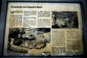
Click here to see more info for this site
Nearby sites
Key: Red: member's photo, Blue: 3rd party photo, Yellow: other image, Green: no photo - please go there and take one, Grey: site destroyed
Download sites to:
KML (Google Earth)
GPX (GPS waypoints)
CSV (Garmin/Navman)
CSV (Excel)
To unlock full downloads you need to sign up as a Contributory Member. Otherwise downloads are limited to 50 sites.
![]()
![]()
Turn off the page maps and other distractions
Nearby sites listing. In the following links * = Image available
308m NNW 326° Auchquhorthies* Stone Circle (NO90199634)
803m SSE 164° Hilton of Cairngrassie* Standing Stone (Menhir) (NO90589531)
1.4km NW 311° Auchlee Cairn* Ring Cairn (NO893970)
1.4km N 11° Cairnwell* Stone Circle (NO90649750)
1.6km WNW 301° Auchlee Circle* Stone Circle (NO890969)
1.8km NNE 26° Craighead Badentoy* Stone Circle (NO91189772)
3.0km WNW 292° Craigentath Ancient Village or Settlement (NO876972)
3.3km WNW 282° East Crossley Ancient Village or Settlement (NO871968)
5.6km SSW 205° Causey Mounth* Ancient Trackway (NO8891)
5.8km WNW 284° Standingstones* Standing Stones (NO847975)
6.2km SSW 202° Cantlayhills Cairn (NO880903)
6.3km N 10° Dunnicaer 1* Class I Pictish Symbol Stone (NJ91500232)
6.5km NNE 14° Tollohill* Ring Cairn (NJ91950235)
7.0km NNW 343° Bieldside* Cairn (NJ88340280)
7.1km SSW 202° Kempston Hill* Standing Stones (NO87678947)
7.5km N 353° Friarsfield* Stone Circle (NJ894035)
7.5km SW 215° White Hill, Aberdeenshire Ancient Village or Settlement (NO860900)
7.9km NW 322° Binghill* Stone Circle (NJ85520237)
8.5km SW 226° Raedykes Roman Camp* Hillfort (NO842902)
8.5km NE 34° Cat Cairn* Cairn (NJ952031)
8.6km NNE 32° Tullos Hut Circles* Ancient Village or Settlement (NJ950034)
8.8km SW 222° Newbigging Earthwork Ancient Village or Settlement (NO844896)
9.0km SW 232° Raedykes NW* Stone Circle (NO832906)
9.0km W 263° South Brachmont Artificial Mound (NO814950)
9.0km SW 220° Findlayston Enclosure Ancient Village or Settlement (NO845892)
View more nearby sites and additional images


 We would like to know more about this location. Please feel free to add a brief description and any relevant information in your own language.
 Wir möchten mehr über diese Stätte erfahren. Bitte zögern Sie nicht, eine kurze Beschreibung und relevante Informationen in Deutsch hinzuzufügen.
 Nous aimerions en savoir encore un peu sur les lieux. S'il vous plaît n'hesitez pas à ajouter une courte description et tous les renseignements pertinents dans votre propre langue.
 Quisieramos informarnos un poco más de las lugares. No dude en añadir una breve descripción y otros datos relevantes en su propio idioma.