


<< Our Photo Pages >> Raedykes Roman Camp - Hillfort in Scotland in Aberdeenshire
Submitted by C_Michael_Hogan on Wednesday, 03 October 2007 Page Views: 16587
Iron Age and Later PrehistorySite Name: Raedykes Roman Camp Alternative Name: Raedykes CastraCountry: Scotland County: Aberdeenshire Type: Hillfort
Nearest Town: Stonehaven Nearest Village: Netherley
Map Ref: NO842902
Latitude: 57.002684N Longitude: 2.261731W
Condition:
| 5 | Perfect |
| 4 | Almost Perfect |
| 3 | Reasonable but with some damage |
| 2 | Ruined but still recognisable as an ancient site |
| 1 | Pretty much destroyed, possibly visible as crop marks |
| 0 | No data. |
| -1 | Completely destroyed |
| 5 | Superb |
| 4 | Good |
| 3 | Ordinary |
| 2 | Not Good |
| 1 | Awful |
| 0 | No data. |
| 5 | Can be driven to, probably with disabled access |
| 4 | Short walk on a footpath |
| 3 | Requiring a bit more of a walk |
| 2 | A long walk |
| 1 | In the middle of nowhere, a nightmare to find |
| 0 | No data. |
| 5 | co-ordinates taken by GPS or official recorded co-ordinates |
| 4 | co-ordinates scaled from a detailed map |
| 3 | co-ordinates scaled from a bad map |
| 2 | co-ordinates of the nearest village |
| 1 | co-ordinates of the nearest town |
| 0 | no data |
Internal Links:
External Links:
I have visited· I would like to visit
megalithicmatt couldn't find on 27th Mar 2011 - their rating: Amb: 4 Access: 3 Note: don't rely on friend's innaccurate iphone GPS. Bring a real map instead.
C_Michael_Hogan have visited here
")
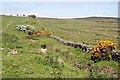
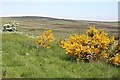
Raedykes Roman Camp was a major encampment of the Roman Army in its northward invasion of Scotland circa 2nd to 3rd century AD. The camp was inhabited by approximately 15,000 to 30,000 soldiers, and was situated a day's march away from two other ancient major military camps: Stracathro Roman Camp and Normandykes Roman Camp. The camp high elevation point, Garrison Hill, commands an expansive view of the North Sea, allowing military communication with the Roman fleet. Moderately well preserved ramparts and defensive ditches are present for extensive runs along portions of the perimeter. A broad scale view of this large site is shown in this photograph of Raedykes Roman Camp from the north by C. Michael Hogan from the British Isles Geograph Project
You may be viewing yesterday's version of this page. To see the most up to date information please register for a free account.
Do not use the above information on other web sites or publications without permission of the contributor.
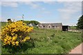
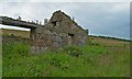
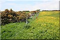
Nearby Images from Geograph Britain and Ireland:
©2010(licence)
©2010(licence)
©2007(licence)
©2010(licence)
©2010(licence)
The above images may not be of the site on this page, they are loaded from Geograph.
Please Submit an Image of this site or go out and take one for us!
Click here to see more info for this site
Nearby sites
Key: Red: member's photo, Blue: 3rd party photo, Yellow: other image, Green: no photo - please go there and take one, Grey: site destroyed
Download sites to:
KML (Google Earth)
GPX (GPS waypoints)
CSV (Garmin/Navman)
CSV (Excel)
To unlock full downloads you need to sign up as a Contributory Member. Otherwise downloads are limited to 50 sites.
Turn off the page maps and other distractions
Nearby sites listing. In the following links * = Image available
632m SSE 161° Newbigging Earthwork Ancient Village or Settlement (NO844896)
1.0km WNW 287° Raedykes SE* Stone Circle (NO832905)
1.0km WNW 287° Campstone Hill Ring Cairn (NO832905)
1.0km SSE 163° Findlayston Enclosure Ancient Village or Settlement (NO845892)
1.1km WNW 292° Raedykes NW* Stone Circle (NO832906)
1.8km E 96° White Hill, Aberdeenshire Ancient Village or Settlement (NO860900)
2.0km WNW 288° Auquhollie* Standing Stone (Menhir) (NO82339080)
2.4km SW 231° Glenton Hill Enclosure Ancient Village or Settlement (NO823887)
2.5km SSW 194° Cheynehill Wood Enclosures Ancient Village or Settlement (NO836878)
3.5km ESE 102° Kempston Hill* Standing Stones (NO87678947)
3.8km E 88° Cantlayhills Cairn (NO880903)
3.9km ENE 78° Causey Mounth* Ancient Trackway (NO8891)
4.2km SE 142° St Ciaran's Well* Holy Well or Sacred Spring (NO868869)
4.4km SSE 168° Kirktown of Fetteresso* Ancient Village or Settlement (NO851859)
4.5km S 174° Fetteresso Cursus Cursus (NO84698570)
4.7km SW 229° Fetteresso Standing Stone* Standing Stone (Menhir) (NO80598713)
4.8km SW 234° Clochanshiels Ancient Village or Settlement (NO803874)
5.5km NW 321° Elsick Mounth* Ancient Trackway (NO807945)
5.5km NNW 330° South Brachmont Artificial Mound (NO814950)
5.7km SSE 157° Woods of Dunnottar Cairn* Cairn (NO864849)
6.2km WNW 286° Cairn-mon-earn* Cairn (NO782919)
6.7km NW 315° Raes Of Clune* Stone Circle (NO7946894949)
6.8km NW 315° Clune Wood* Cairn (NO7934695036)
6.8km SE 144° Dunnicaer Hillfort* Hillfort (NO88218464)
6.9km S 185° Dunnottar Stone Circle (NO836833)
View more nearby sites and additional images


 We would like to know more about this location. Please feel free to add a brief description and any relevant information in your own language.
 Wir möchten mehr über diese Stätte erfahren. Bitte zögern Sie nicht, eine kurze Beschreibung und relevante Informationen in Deutsch hinzuzufügen.
 Nous aimerions en savoir encore un peu sur les lieux. S'il vous plaît n'hesitez pas à ajouter une courte description et tous les renseignements pertinents dans votre propre langue.
 Quisieramos informarnos un poco más de las lugares. No dude en añadir una breve descripción y otros datos relevantes en su propio idioma.