

<< Our Photo Pages >> Hilton of Cairngrassie - Standing Stone (Menhir) in Scotland in Aberdeenshire
Submitted by cosmic on Wednesday, 11 August 2004 Page Views: 6373
Neolithic and Bronze AgeSite Name: Hilton of CairngrassieCountry: Scotland County: Aberdeenshire Type: Standing Stone (Menhir)
Map Ref: NO90589531
Latitude: 57.048764N Longitude: 2.156896W
Condition:
| 5 | Perfect |
| 4 | Almost Perfect |
| 3 | Reasonable but with some damage |
| 2 | Ruined but still recognisable as an ancient site |
| 1 | Pretty much destroyed, possibly visible as crop marks |
| 0 | No data. |
| -1 | Completely destroyed |
| 5 | Superb |
| 4 | Good |
| 3 | Ordinary |
| 2 | Not Good |
| 1 | Awful |
| 0 | No data. |
| 5 | Can be driven to, probably with disabled access |
| 4 | Short walk on a footpath |
| 3 | Requiring a bit more of a walk |
| 2 | A long walk |
| 1 | In the middle of nowhere, a nightmare to find |
| 0 | No data. |
| 5 | co-ordinates taken by GPS or official recorded co-ordinates |
| 4 | co-ordinates scaled from a detailed map |
| 3 | co-ordinates scaled from a bad map |
| 2 | co-ordinates of the nearest village |
| 1 | co-ordinates of the nearest town |
| 0 | no data |
Internal Links:
External Links:
I have visited· I would like to visit
pawel would like to visit
")
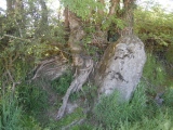
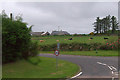
Standing stone on a small rise 150m north of the farm of the same name.
The stone is 2.1m high and is wedge shaped with flat sides facing north and south.
You may be viewing yesterday's version of this page. To see the most up to date information please register for a free account.
")
Do not use the above information on other web sites or publications without permission of the contributor.
coldrum has found this location on Google Street View:
Nearby Images from Geograph Britain and Ireland:
©2007(licence)
©2006(licence)
©2009(licence)
©2017(licence)
©2009(licence)
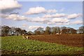
The above images may not be of the site on this page, they are loaded from Geograph.
Please Submit an Image of this site or go out and take one for us!
Click here to see more info for this site
Nearby sites
Key: Red: member's photo, Blue: 3rd party photo, Yellow: other image, Green: no photo - please go there and take one, Grey: site destroyed
Download sites to:
KML (Google Earth)
GPX (GPS waypoints)
CSV (Garmin/Navman)
CSV (Excel)
To unlock full downloads you need to sign up as a Contributory Member. Otherwise downloads are limited to 50 sites.
Turn off the page maps and other distractions
Nearby sites listing. In the following links * = Image available
803m NNW 344° Old Bourtreebush* Stone Circle (NO9036096083)
1.1km NNW 339° Auchquhorthies* Stone Circle (NO90199634)
2.1km NW 323° Auchlee Cairn* Ring Cairn (NO893970)
2.2km N 1° Cairnwell* Stone Circle (NO90649750)
2.2km NW 315° Auchlee Circle* Stone Circle (NO890969)
2.5km NNE 14° Craighead Badentoy* Stone Circle (NO91189772)
3.5km WNW 302° Craigentath Ancient Village or Settlement (NO876972)
3.8km WNW 293° East Crossley Ancient Village or Settlement (NO871968)
5.0km SSW 211° Causey Mounth* Ancient Trackway (NO8891)
5.6km SSW 207° Cantlayhills Cairn (NO880903)
6.3km WNW 290° Standingstones* Standing Stones (NO847975)
6.5km SSW 206° Kempston Hill* Standing Stones (NO87678947)
7.0km SW 221° White Hill, Aberdeenshire Ancient Village or Settlement (NO860900)
7.1km N 7° Dunnicaer 1* Class I Pictish Symbol Stone (NJ91500232)
7.2km N 11° Tollohill* Ring Cairn (NJ91950235)
7.8km NNW 343° Bieldside* Cairn (NJ88340280)
8.2km SW 231° Raedykes Roman Camp* Hillfort (NO842902)
8.3km N 352° Friarsfield* Stone Circle (NJ894035)
8.4km SW 227° Newbigging Earthwork Ancient Village or Settlement (NO844896)
8.6km SW 225° Findlayston Enclosure Ancient Village or Settlement (NO845892)
8.7km NW 324° Binghill* Stone Circle (NJ85520237)
8.7km WSW 237° Raedykes NW* Stone Circle (NO832906)
8.8km WSW 237° Campstone Hill Ring Cairn (NO832905)
8.8km WSW 237° Raedykes SE* Stone Circle (NO832905)
9.0km NNE 30° Cat Cairn* Cairn (NJ952031)
View more nearby sites and additional images


 We would like to know more about this location. Please feel free to add a brief description and any relevant information in your own language.
 Wir möchten mehr über diese Stätte erfahren. Bitte zögern Sie nicht, eine kurze Beschreibung und relevante Informationen in Deutsch hinzuzufügen.
 Nous aimerions en savoir encore un peu sur les lieux. S'il vous plaît n'hesitez pas à ajouter une courte description et tous les renseignements pertinents dans votre propre langue.
 Quisieramos informarnos un poco más de las lugares. No dude en añadir una breve descripción y otros datos relevantes en su propio idioma.