<< Our Photo Pages >> Causey Mounth - Ancient Trackway in Scotland in Aberdeenshire
Submitted by C_Michael_Hogan on Saturday, 03 November 2007 Page Views: 23400
Multi-periodSite Name: Causey Mounth Alternative Name: Cowie MounthCountry: Scotland
NOTE: This site is 1.9 km away from the location you searched for.
County: Aberdeenshire Type: Ancient Trackway
Nearest Town: Stonehaven Nearest Village: Bridge of Muchalls
Map Ref: NO8891
Latitude: 57.009986N Longitude: 2.199214W
Condition:
| 5 | Perfect |
| 4 | Almost Perfect |
| 3 | Reasonable but with some damage |
| 2 | Ruined but still recognisable as an ancient site |
| 1 | Pretty much destroyed, possibly visible as crop marks |
| 0 | No data. |
| -1 | Completely destroyed |
| 5 | Superb |
| 4 | Good |
| 3 | Ordinary |
| 2 | Not Good |
| 1 | Awful |
| 0 | No data. |
| 5 | Can be driven to, probably with disabled access |
| 4 | Short walk on a footpath |
| 3 | Requiring a bit more of a walk |
| 2 | A long walk |
| 1 | In the middle of nowhere, a nightmare to find |
| 0 | No data. |
| 5 | co-ordinates taken by GPS or official recorded co-ordinates |
| 4 | co-ordinates scaled from a detailed map |
| 3 | co-ordinates scaled from a bad map |
| 2 | co-ordinates of the nearest village |
| 1 | co-ordinates of the nearest town |
| 0 | no data |
Internal Links:
External Links:
I have visited· I would like to visit
C_Michael_Hogan has visited here
")
The Causey Mounth is an ancient trackway spanning the coastal mounth spur of the Grampian Mountains in Kincardineshire, Scotland. The route is intimately connected to settlement and ancient monuments of the Pictish peoples of this area dating to 2000 BC. This track was developed as the main drovers' road and highway connecting Stonehaven and Aberdeen at least as early as the 12th century AD, and it continued to function as the chief route between these two cities until the mid 1900s, when modern highway construction of the A90 road transpired.. The geometry of this track is a series of linear segments with remarkable consistency in the north/south direction, given the undulating terrain fraught with extensive bogs. The track was constructed with enormous boulders providing a foundation through peaty and swampy terrain. There are some extant paved and usable sections of this road over part of the alignment; however, many parts of the prehistoric route are no more than footpaths, and in some cases the road vanishes into agricultural fields. Constructed in the Middle Ages, the Causey Mounth was created as an elevated rock causeway to span many of the boggy areas such as the Portlethen Moss. A portion of the alignment of the Causey Mounth is illustrated on the UK Ordinance Survey Map. (Landranger, 2004) although a large fraction of the route cannot be navigated by a conventional passenger vehicle such as the ford at the Burn of Pheppie. If you are in the region, local lodges to stay in when visiting can be found here: https://hottubbreakaway.co.uk/lodges/scotland/ The work herein is based upon analysis of the extant literature and my field research along the Causey Mounth in the years 2000 through 2007 .
PREHISTORY. The Causey Mounth is associated with a series of prehistoric monuments including cairns, stone circles and standing stones. The Causey Mounth may have indeed been the natural connection amongst these coastal sites of the ancient Pictish peoples, who arrived locally about 2000 BC to farm the fertile hillsides. (Watt, 1984) Some of the major monuments of the Neolithic and Bronze Ages lying along the route are Cantlayhills cairn, Kempstone Hill standing stones, Hilton of Cairngrassie standing stone, Old Bourtreebush stone circle, Aquhorthies stone circle, Auchlee cairn, Auchlee stone circle, Cairnwell ring cairn and Craighead Badentoy stone circle.
ROMAN TO MEDIEVAL. Viewed by the Romans, the Mounth, or easternmost range of the Grampian Mountains, posed a formidable terrestrial barrier isolating the northeast of Scotland from the Scottish Lowlands. This mountainous barrier, combined with the local bogs, was a factor in determining the Romans' coastal march northward from the Raedykes Roman Camp The Romans chose a more inland route to avoid the boggy undulating terrain of the Mounth. Several scholars (Roy, 1754) (Surenne, 1827) (Watt, 1984) suggest that Mons Graupius, the earliest recorded battle in Scottish history in 83 AD, occurred on Megray or Kempstone Hill, essentially along the Causey Mounth. My review of the Tacitus account of Mons Graupius supports the location of the battle in this vicinity, since Tacitus references the signaling communication with the Roman fleet and the battle site lying between a Roman camp (eg Raedykes) and a coastal hill. Furthermore, one of the four greatest Roman coin hoards of silver denarii was found at Megray Hill near the Causey Mounth.
By the twelfth century AD construction of the Causey Mounth had begun to connect these two regions of Highlands and Lowlands; in these early times the only structures along the route were Dunnottar Castle (to the south); Cowie Castle guarding the southern terminus; the Chapel of St Nathalan along the coast somewhat to the east of the Causey Mounth and Gillybrands coaching inn. It is not unlikely that there was also an ancient hillfort at the site of Muchalls Castle, pre-dating the Fraser towerhouse.
GENERAL ROUTE. The route was specifically designed to connect the coastal portion of Stonehaven to a crossing of the River Dee at the southern edge of present day Aberdeen. Stonehaven was most noted in the Middle Ages for the fortress of Dunnottar Castle, controlling land and sea movements of military might from its rugged promontory jutting into the North Sea. This fortress along with Cowie Castle at the north of Stonehaven effectively checked all coastal land and sea movements to the north. Proceeding north from Cowie Castle, the Causey Mounth climbs the Hill of Megray and passes over Kempstone Hill before crossing the Burn of Muchalls at the Bridge of Muchalls; thence it proceeds norhward past Muchalls Castle. The route north of Muchalls Castle was that taken by William Keith, 7th Earl Marischal and the Marquess of Montrose when they led a Covenanter army of 9000 men in the first battle of the Civil War in 1639 after marshalling at Muchalls Castle.. The route passes the ruins of the Episcopal Chapels, dating to 1624 (Christie, 2007) situated on lands of the Muchalls Castle Estate, and thence northerly beside the present day Saint Ternan's Church, which is the successor facility to the ruined chapels of Muchalls Castle.
North of St. Ternan's Church, the Causey Mounth proceeds briefly as a paved road, but quickly turns to an earthen track becoming muddier until the Burn of Pheppie is crossed via a small wooden footbridge. The elevation rises passing Nether Cairnhill steading on the west. Now the elevation rises steadily along the earthen track for another 500 meters until the ridge top of Windyedge is met. The Causey Mounth proceeds straight across a paved road (the Newtonhill Cookney Road). Continuing north the track now descends for 700 meters until it crosses the Burn of Elsick via an old stone bridge. Now proceeding north the unpaved track becomes less boggy and passes Gillybrands steading on the west approximately 150 meters north of the Burn of Elsick.
Around 200 meters north of Gillybrands is the access drive to Elsick House, an historic manor house owned by the Duke of Fife. The walker proceeds straight across the paved highway as the Causey Mounth leads in to a view of the large Cairngrassie standing stone in an agricultural field on the east side of the Causey Mounth. Further north on the Bourtreebush Estate, the route passes by the Old Bourtreebush stone circle and eventually reaches Badentoy. A part of this ancient road is still in paved public use today from Badentoy, past Banchory-Devenick crossroads to the South Deeside road. Originally a ferry would have conveyed medieval travelers across the Dee..
REFERENCES.
* Landranger 45, United Kingdom Ordnance Survey Map, Stonehaven and Banchory, 1:50,000 scale (2004)
* William Roy (1793) ‘'The military antiquities of the Romans in Britain'‘
* Gabriel Jacques Surenne (1827) ‘'Letter to Sir Walter Scott'‘
* Archibald Watt (1984) ‘'Highways and Biways Round Stonehaven'‘, Gourdas House Publishers, Aberdeen ISBN 0 907 301 07X
* Christie Lineage, Skateraw (2007)
(The foregoing is original work of C. Michael Hogan prepared for the Megalithic Portal)
You may be viewing yesterday's version of this page. To see the most up to date information please register for a free account.
")
")
")
Do not use the above information on other web sites or publications without permission of the contributor.
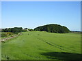
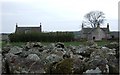
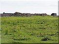
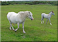
Nearby Images from Geograph Britain and Ireland:
©2023(licence)
©2007(licence)
©2008(licence)

©2006(licence)
©2008(licence)
The above images may not be of the site on this page, they are loaded from Geograph.
Please Submit an Image of this site or go out and take one for us!
Click here to see more info for this site
Nearby sites
Key: Red: member's photo, Blue: 3rd party photo, Yellow: other image, Green: no photo - please go there and take one, Grey: site destroyed
Download sites to:
KML (Google Earth)
GPX (GPS waypoints)
CSV (Garmin/Navman)
CSV (Excel)
To unlock full downloads you need to sign up as a Contributory Member. Otherwise downloads are limited to 50 sites.
Turn off the page maps and other distractions
Nearby sites listing. In the following links * = Image available
699m S 180° Cantlayhills Cairn (NO880903)
1.6km SSW 192° Kempston Hill* Standing Stones (NO87678947)
2.2km WSW 243° White Hill, Aberdeenshire Ancient Village or Settlement (NO860900)
3.9km WSW 249° Newbigging Earthwork Ancient Village or Settlement (NO844896)
3.9km WSW 258° Raedykes Roman Camp* Hillfort (NO842902)
3.9km WSW 243° Findlayston Enclosure Ancient Village or Settlement (NO845892)
4.3km SSW 196° St Ciaran's Well* Holy Well or Sacred Spring (NO868869)
4.8km W 265° Raedykes NW* Stone Circle (NO832906)
4.8km W 264° Campstone Hill Ring Cairn (NO832905)
4.8km W 264° Raedykes SE* Stone Circle (NO832905)
5.0km NNE 31° Hilton of Cairngrassie* Standing Stone (Menhir) (NO90589531)
5.4km SW 234° Cheynehill Wood Enclosures Ancient Village or Settlement (NO836878)
5.6km NNE 25° Old Bourtreebush* Stone Circle (NO9036096083)
5.7km W 268° Auquhollie* Standing Stone (Menhir) (NO82339080)
5.8km NNE 22° Auchquhorthies* Stone Circle (NO90199634)
5.9km SSW 209° Kirktown of Fetteresso* Ancient Village or Settlement (NO851859)
5.9km N 351° East Crossley Ancient Village or Settlement (NO871968)
6.0km N 9° Auchlee Circle* Stone Circle (NO890969)
6.1km WSW 248° Glenton Hill Enclosure Ancient Village or Settlement (NO823887)
6.1km NNE 12° Auchlee Cairn* Ring Cairn (NO893970)
6.2km N 356° Craigentath Ancient Village or Settlement (NO876972)
6.2km SSW 212° Fetteresso Cursus Cursus (NO84698570)
6.3km SSW 195° Woods of Dunnottar Cairn* Cairn (NO864849)
6.4km S 178° Dunnicaer Hillfort* Hillfort (NO88218464)
7.0km NNE 22° Cairnwell* Stone Circle (NO90649750)
View more nearby sites and additional images


 We would like to know more about this location. Please feel free to add a brief description and any relevant information in your own language.
 Wir möchten mehr über diese Stätte erfahren. Bitte zögern Sie nicht, eine kurze Beschreibung und relevante Informationen in Deutsch hinzuzufügen.
 Nous aimerions en savoir encore un peu sur les lieux. S'il vous plaît n'hesitez pas à ajouter une courte description et tous les renseignements pertinents dans votre propre langue.
 Quisieramos informarnos un poco más de las lugares. No dude en añadir una breve descripción y otros datos relevantes en su propio idioma.