<< Our Photo Pages >> Brandsbutt stone circle - Stone Circle in Scotland in Aberdeenshire
Submitted by theCaptain on Monday, 29 December 2003 Page Views: 13353
Neolithic and Bronze AgeSite Name: Brandsbutt stone circleCountry: Scotland County: Aberdeenshire Type: Stone Circle
Nearest Town: Inverurie Nearest Village: Inverurie
Map Ref: NJ76012240 Landranger Map Number: 38
Latitude: 57.291575N Longitude: 2.399661W
Condition:
| 5 | Perfect |
| 4 | Almost Perfect |
| 3 | Reasonable but with some damage |
| 2 | Ruined but still recognisable as an ancient site |
| 1 | Pretty much destroyed, possibly visible as crop marks |
| 0 | No data. |
| -1 | Completely destroyed |
| 5 | Superb |
| 4 | Good |
| 3 | Ordinary |
| 2 | Not Good |
| 1 | Awful |
| 0 | No data. |
| 5 | Can be driven to, probably with disabled access |
| 4 | Short walk on a footpath |
| 3 | Requiring a bit more of a walk |
| 2 | A long walk |
| 1 | In the middle of nowhere, a nightmare to find |
| 0 | No data. |
| 5 | co-ordinates taken by GPS or official recorded co-ordinates |
| 4 | co-ordinates scaled from a detailed map |
| 3 | co-ordinates scaled from a bad map |
| 2 | co-ordinates of the nearest village |
| 1 | co-ordinates of the nearest town |
| 0 | no data |
Internal Links:
External Links:
I have visited· I would like to visit
stolinskie visited on 1st Jan 2025 - their rating: Cond: 1 Amb: 1 Access: 5
TheCaptain SandyG tyrianterror have visited here
")
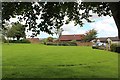
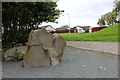
A circle is marked out on the green where the original circle was thought to be, and there are a couple of the remaining stones positioned within the border at the edge of the green.
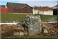
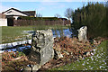
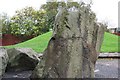
The carved Pictish stone is positioned just to the west, and has been recreated from several broken pieces. There are many more bits of stone positioned nearby.
You may be viewing yesterday's version of this page. To see the most up to date information please register for a free account.
")
")
")
Do not use the above information on other web sites or publications without permission of the contributor.
Nearby Images from Geograph Britain and Ireland:
©2012(licence)
©2016(licence)
©2016(licence)
©2012(licence)
©2008(licence)
The above images may not be of the site on this page, they are loaded from Geograph.
Please Submit an Image of this site or go out and take one for us!
Click here to see more info for this site
Nearby sites
Key: Red: member's photo, Blue: 3rd party photo, Yellow: other image, Green: no photo - please go there and take one, Grey: site destroyed
Download sites to:
KML (Google Earth)
GPX (GPS waypoints)
CSV (Garmin/Navman)
CSV (Excel)
To unlock full downloads you need to sign up as a Contributory Member. Otherwise downloads are limited to 50 sites.
Turn off the page maps and other distractions
Nearby sites listing. In the following links * = Image available
18m W 279° Brandsbutt* Class I Pictish Symbol Stone (NJ7599222403)
784m SSW 211° Blackhall Stones* Modern Stone Circle etc (NJ75602173)
851m S 176° Blackhall Roundabout* Modern Stone Circle etc (NJ76072155)
1.4km N 3° East Balhalgardy* Class I Pictish Symbol Stone (NJ76082379)
1.5km ESE 122° Carnegie Museum (Inverurie)* Museum (NJ773216)
1.9km N 356° Balhalgardy Stone Circle* Stone Circle (NJ759243)
2.0km SE 139° Conyng Hillock Artificial Mound (NJ773209)
2.1km WNW 302° Drimmies* Class I Pictish Symbol Stone (NJ74262350)
2.7km SE 131° Inverurie 1* Class I Pictish Symbol Stone (NJ78022063)
2.8km NNW 332° Liggar's Stane* Standing Stone (Menhir) (NJ74702488)
3.0km ESE 110° Keith Hall* Class I Pictish Symbol Stone (NJ78802136)
3.0km WNW 304° Balquhain* Stone Circle (NJ73502409)
3.2km WSW 240° Easter Aquhorthies* Stone Circle (NJ73232079)
3.2km SE 144° Broomend of Crichie North circle Stone Circle (NJ779198)
3.3km SE 145° Broomend Of Crichie Stone Circle / Henge* Henge (NJ77911968)
3.3km SE 145° Broomend of Crichie Pictish Symbol Stone* Class I Pictish Symbol Stone (NJ77921967)
3.3km SE 145° Broomend of Crichie Avenue* Multiple Stone Rows / Avenue (NJ7791419653)
3.4km SE 145° Broomend of Crichie Stone Row / Alignment (NJ7792119591)
3.5km SSE 146° Broomend of Crichie Row Mid Stone Row / Alignment (NJ7792919479)
3.5km SSE 166° Bruce's Camp* Hillfort (NJ76851900)
3.7km SSE 148° Gardeners House Standing Stone Standing Stone (Menhir) (NJ7794919226)
3.7km SSE 150° Broomend Stone Seat / Cists* Cist (NJ77871917)
4.8km ENE 58° Kirkton Of Bourtie* Stone Circle (NJ80092488)
5.0km SSE 151° Fullerton* Stone Circle (NJ7839517969)
5.1km ENE 61° Bourtie Pictish Stone* Class I Pictish Symbol Stone (NJ80462485)
View more nearby sites and additional images


 We would like to know more about this location. Please feel free to add a brief description and any relevant information in your own language.
 Wir möchten mehr über diese Stätte erfahren. Bitte zögern Sie nicht, eine kurze Beschreibung und relevante Informationen in Deutsch hinzuzufügen.
 Nous aimerions en savoir encore un peu sur les lieux. S'il vous plaît n'hesitez pas à ajouter une courte description et tous les renseignements pertinents dans votre propre langue.
 Quisieramos informarnos un poco más de las lugares. No dude en añadir una breve descripción y otros datos relevantes en su propio idioma.