<< Our Photo Pages >> Rainbarrows - Round Barrow(s) in England in Dorset
Submitted by JimChampion on Monday, 09 April 2007 Page Views: 17997
Neolithic and Bronze AgeSite Name: RainbarrowsCountry: England
NOTE: This site is 1.3 km away from the location you searched for.
County: Dorset Type: Round Barrow(s)
Nearest Town: Dorchester Nearest Village: Higher Bockhampton
Map Ref: SY735920
Latitude: 50.727010N Longitude: 2.376812W
Condition:
| 5 | Perfect |
| 4 | Almost Perfect |
| 3 | Reasonable but with some damage |
| 2 | Ruined but still recognisable as an ancient site |
| 1 | Pretty much destroyed, possibly visible as crop marks |
| 0 | No data. |
| -1 | Completely destroyed |
| 5 | Superb |
| 4 | Good |
| 3 | Ordinary |
| 2 | Not Good |
| 1 | Awful |
| 0 | No data. |
| 5 | Can be driven to, probably with disabled access |
| 4 | Short walk on a footpath |
| 3 | Requiring a bit more of a walk |
| 2 | A long walk |
| 1 | In the middle of nowhere, a nightmare to find |
| 0 | No data. |
| 5 | co-ordinates taken by GPS or official recorded co-ordinates |
| 4 | co-ordinates scaled from a detailed map |
| 3 | co-ordinates scaled from a bad map |
| 2 | co-ordinates of the nearest village |
| 1 | co-ordinates of the nearest town |
| 0 | no data |
Internal Links:
External Links:
I have visited· I would like to visit
JimChampion has visited here
")
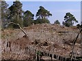
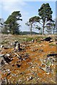
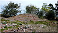
The barrows have a connection to Dorset's most famous author, Thomas Hardy, who was born and lived in a cottage on the edge of the heath at nearby at Higher Bockington. In his books Hardy called this area of heathland "Egdon Heath", and some of it (including the part around the Rainbarrows) is being restored to heathland as part of the "Hardy's Egdon Heath Project". The Rainbarrows feature as locations in Hardy's 1878 novel The Return of the Native and his poem The Sheep Boy.
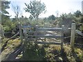
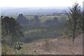
Access The barrows are on an upper terrace of a south-facing slope overlooking the Frome valley. They lie alongside a gravel track (public footpath), south of the Roman Road, within Puddletown Forest. There are several parking places around the edge of Puddletown Forest.
Thomas Hardy's cottage is a National Trust visitor attraction, and there is parking at Higher Bockhampton. To reach the Rainbarrows from Hardy's Cottage follow the signed footpath to Rushy Pond, then the Roman Road permissive path, then right along a footpath that cuts across the Roman Road (before the Roman Road heads steeply downhill).
You may be viewing yesterday's version of this page. To see the most up to date information please register for a free account.
")
")
Do not use the above information on other web sites or publications without permission of the contributor.
Nearby Images from Geograph Britain and Ireland:
©2007(licence)
©2007(licence)
©2008(licence)
©2018(licence)
©2007(licence)
The above images may not be of the site on this page, they are loaded from Geograph.
Please Submit an Image of this site or go out and take one for us!
Click here to see more info for this site
Nearby sites
Key: Red: member's photo, Blue: 3rd party photo, Yellow: other image, Green: no photo - please go there and take one, Grey: site destroyed
Download sites to:
KML (Google Earth)
GPX (GPS waypoints)
CSV (Garmin/Navman)
CSV (Excel)
To unlock full downloads you need to sign up as a Contributory Member. Otherwise downloads are limited to 50 sites.
Turn off the page maps and other distractions
Nearby sites listing. In the following links * = Image available
761m SSW 203° Heedless William's Stone* Standing Stone (Menhir) (SY732913)
3.2km SW 231° Mount Pleasant (Dorset)* Henge (SY710900)
3.7km SW 236° Flagstones Enclosure* Causewayed Enclosure (SY704899)
4.1km SSW 206° Whitcombe* Standing Stone (Menhir) (SY717883)
4.2km WSW 239° Fordington (Two Barrows) Barrow* Barrow Cemetery (SY69888987)
4.4km WSW 251° Dorchester, Tudor Arcade* Timber Circle (SY693906)
4.6km WSW 253° Dorset County Museum* Museum (SY691907)
4.6km WSW 257° Dorchester Roman Town House* Ancient Village or Settlement (SY68969095)
4.7km NW 310° Culliford Tree* Barrow Cemetery (SY699950)
4.9km SW 230° Conygar Hill Barrows* Barrow Cemetery (SY697889)
4.9km WSW 245° Maumbury Rings* Henge (SY69018992)
5.2km SSW 196° Little Mayne* Stone Circle (SY720870)
5.4km W 260° Poundbury* Hillfort (SY68199113)
6.1km SW 234° Herringston Long Barrow* Long Barrow (SY68548844)
6.2km SW 234° Herringston Bowl Barrow* Round Barrow(s) (SY68478842)
6.6km W 269° Bradford Peverell 2* Long Barrow (SY669919)
7.2km SSW 210° Whitcombe 1* Long Barrow (SY699858)
7.3km WSW 248° Maiden Castle Barrow Cemetery* Barrow Cemetery (SY66698927)
7.3km WSW 246° Maiden Castle Linear Earthwork Misc. Earthwork (SY66798902)
7.4km WSW 247° Lanceborough Enclosure Misc. Earthwork (SY66658920)
7.4km WSW 249° Maiden Castle Long Barrow 2 Long Barrow (SY66578938)
7.4km WSW 242° Maiden Castle Bank Barrow* Long Barrow (SY66928850)
7.4km WSW 241° Maiden Castle Causewayed Enclosure* Causewayed Enclosure (SY66938848)
7.4km SW 220° Came Down* Barrow Cemetery (SY687863)
7.5km SSW 206° Broadmayne Bank Barrow* Long Barrow (SY702853)
View more nearby sites and additional images


 We would like to know more about this location. Please feel free to add a brief description and any relevant information in your own language.
 Wir möchten mehr über diese Stätte erfahren. Bitte zögern Sie nicht, eine kurze Beschreibung und relevante Informationen in Deutsch hinzuzufügen.
 Nous aimerions en savoir encore un peu sur les lieux. S'il vous plaît n'hesitez pas à ajouter une courte description et tous les renseignements pertinents dans votre propre langue.
 Quisieramos informarnos un poco más de las lugares. No dude en añadir una breve descripción y otros datos relevantes en su propio idioma.