


<< Our Photo Pages >> High Park Cross Dyke - Ancient Village or Settlement in England in Shropshire
Submitted by TimPrevett on Saturday, 07 August 2004 Page Views: 7385
Multi-periodSite Name: High Park Cross DykeCountry: England County: Shropshire Type: Ancient Village or Settlement
Nearest Town: Church Stretton Nearest Village: All Stretton
Map Ref: SO443967
Latitude: 52.565263N Longitude: 2.823161W
Condition:
| 5 | Perfect |
| 4 | Almost Perfect |
| 3 | Reasonable but with some damage |
| 2 | Ruined but still recognisable as an ancient site |
| 1 | Pretty much destroyed, possibly visible as crop marks |
| 0 | No data. |
| -1 | Completely destroyed |
| 5 | Superb |
| 4 | Good |
| 3 | Ordinary |
| 2 | Not Good |
| 1 | Awful |
| 0 | No data. |
| 5 | Can be driven to, probably with disabled access |
| 4 | Short walk on a footpath |
| 3 | Requiring a bit more of a walk |
| 2 | A long walk |
| 1 | In the middle of nowhere, a nightmare to find |
| 0 | No data. |
| 5 | co-ordinates taken by GPS or official recorded co-ordinates |
| 4 | co-ordinates scaled from a detailed map |
| 3 | co-ordinates scaled from a bad map |
| 2 | co-ordinates of the nearest village |
| 1 | co-ordinates of the nearest town |
| 0 | no data |
Internal Links:
External Links:
I have visited· I would like to visit
TheWhiteRider TimPrevett have visited here
")
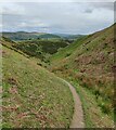
At well over 1100 feet long, High Park Cross Dyke is the longest of the main Long Mynd Bronze Age Cross Dykes.
It stretches across a northern hill of The Long Mynd, to the edge of Jonathan's Hollow to the south, and across the hillside of High Park to the north. This forms a barrier east - west across the area concerned.
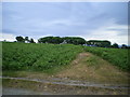
The northernmost part of the dyke is within enclosed farmland, where it is some 20 feet wide and 3 feet high, with trees growing along its ridge. Cropmarks have shown there was also a ditch on the west side.
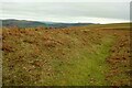
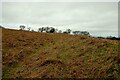
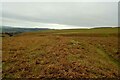
The remainder is on open moorland, and easily accessible. These is a clear ditch, some 16 feet across, and 2 feet deep, making the joining edge of the dyke 4 feet high, with a width of 25 feet.
Some parts of the dyke have had erosion control of a sort carried out upon them. In places chicken wire is visible, stuck to the contours of the monument. However, there seems to be systematic damage happening to the earthwork on its eastern side, at the northern end on the moorland. Semi-circular cut-outs are visible at frequent intervals.
Where the farmland joins the moorland, there is a track intersecting the dyke. Parallel to the main dyke on the west side for some 200 feet is another lower, narrow bank. This is indicative of the strengthening of the earthworks, and likely points to the antiquity of the track.
You may be viewing yesterday's version of this page. To see the most up to date information please register for a free account.
")
")
")
")
Do not use the above information on other web sites or publications without permission of the contributor.
Nearby Images from Geograph Britain and Ireland:
©2010(licence)
©2024(licence)
©2024(licence)
©2024(licence)
©2022(licence)
The above images may not be of the site on this page, they are loaded from Geograph.
Please Submit an Image of this site or go out and take one for us!
Click here to see more info for this site
Nearby sites
Key: Red: member's photo, Blue: 3rd party photo, Yellow: other image, Green: no photo - please go there and take one, Grey: site destroyed
Download sites to:
KML (Google Earth)
GPX (GPS waypoints)
CSV (Garmin/Navman)
CSV (Excel)
To unlock full downloads you need to sign up as a Contributory Member. Otherwise downloads are limited to 50 sites.
Turn off the page maps and other distractions
Nearby sites listing. In the following links * = Image available
1.3km W 263° Robin Hood's Butts (Shropshire)* Round Barrow(s) (SO43029655)
1.5km W 275° Henley Knap Bowl Barrow* Round Barrow(s) (SO42799685)
1.9km W 270° Wildmoor Bowl Barrow* Round Barrow(s) (SO42409672)
2.0km ESE 113° Castle Hill (Shropshire)* Hillfort (SO461959)
2.0km S 174° Bodbury Ring* Hillfort (SO445947)
2.3km WSW 238° Long Mynd C* Round Barrow(s) (SO423955)
2.5km S 187° The Devil's Mouth Cross Dyke* Misc. Earthwork (SO43959425)
2.5km WSW 239° Shooting Box Disc Barrow* Round Barrow(s) (SO421954)
2.8km SW 217° Long Mynd A* Round Barrow(s) (SO426945)
2.9km SW 223° Boiling Well (Long Mynd)* Round Barrow(s) (SO423946)
3.2km SSE 162° Stretton Sheela* Early Christian Sculptured Stone (SO45239368)
3.4km WNW 295° Ratlinghope Hill Bowl Barrow* Round Barrow(s) (SO41179817)
3.5km S 184° Ashlet Hill Bowl Barrow Round Barrow(s) (SO440932)
3.6km W 279° Ratlinghope Hill Camp* Hillfort (SO407973)
3.7km ESE 112° Caer Caradoc (Church Stretton)* Hillfort (SO477953)
3.9km WNW 286° Castle Ring (Stitt Hill)* Hillfort (SO405978)
4.0km ESE 110° Caer Caradoc Round Barrow* Round Barrow(s) (SO48059529)
4.2km SW 228° Pole Cottage* Round Barrow(s) (SO411939)
4.3km SSW 202° Barrister's Plain Cross Dyke* Ancient Village or Settlement (SO426927)
4.4km SW 218° Long Mynd B* Round Barrow(s) (SO41539330)
4.5km SE 128° Hope Bowdler Hill* Cairn (SO47779389)
4.5km SSW 198° Cross Dyke Bowl Barrow North* Round Barrow(s) (SO42899244)
4.5km SSW 198° Cross Dyke Bowl Barrow South* Round Barrow(s) (SO42869241)
4.6km NW 310° Leasowes Barrow* Round Barrow(s) (SO408997)
5.2km E 81° The Lawley (Summit)* Hillfort (SO49459745)
View more nearby sites and additional images


 We would like to know more about this location. Please feel free to add a brief description and any relevant information in your own language.
 Wir möchten mehr über diese Stätte erfahren. Bitte zögern Sie nicht, eine kurze Beschreibung und relevante Informationen in Deutsch hinzuzufügen.
 Nous aimerions en savoir encore un peu sur les lieux. S'il vous plaît n'hesitez pas à ajouter une courte description et tous les renseignements pertinents dans votre propre langue.
 Quisieramos informarnos un poco más de las lugares. No dude en añadir una breve descripción y otros datos relevantes en su propio idioma.