


<< Our Photo Pages >> The Devil's Mouth Cross Dyke - Misc. Earthwork in England in Shropshire
Submitted by TimPrevett on Thursday, 03 June 2004 Page Views: 17354
Multi-periodSite Name: The Devil's Mouth Cross DykeCountry: England County: Shropshire Type: Misc. Earthwork
Nearest Town: Church Stretton
Map Ref: SO43959425 Landranger Map Number: 137
Latitude: 52.543204N Longitude: 2.827909W
Condition:
| 5 | Perfect |
| 4 | Almost Perfect |
| 3 | Reasonable but with some damage |
| 2 | Ruined but still recognisable as an ancient site |
| 1 | Pretty much destroyed, possibly visible as crop marks |
| 0 | No data. |
| -1 | Completely destroyed |
| 5 | Superb |
| 4 | Good |
| 3 | Ordinary |
| 2 | Not Good |
| 1 | Awful |
| 0 | No data. |
| 5 | Can be driven to, probably with disabled access |
| 4 | Short walk on a footpath |
| 3 | Requiring a bit more of a walk |
| 2 | A long walk |
| 1 | In the middle of nowhere, a nightmare to find |
| 0 | No data. |
| 5 | co-ordinates taken by GPS or official recorded co-ordinates |
| 4 | co-ordinates scaled from a detailed map |
| 3 | co-ordinates scaled from a bad map |
| 2 | co-ordinates of the nearest village |
| 1 | co-ordinates of the nearest town |
| 0 | no data |
Internal Links:
External Links:
I have visited· I would like to visit
Couplands visited on 23rd Feb 2023 - their rating: Cond: 2 Amb: 4 Access: 2
TimPrevett have visited here
")
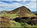
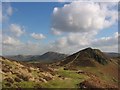
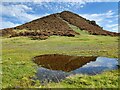
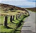
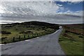
The Devil's Mouth Cross Dyke is the shortest and most accessible cross dyke on the archaeologically rich Long Mynd. It is over 400 feet long, with a 100 feet section missing where the Burway Road cuts through the feature as the road moves away from the precipitous drop into Carding Mill Valley. The whole area is under the management of The National Trust. It is important to point out that the road is very narrow, with many passing places. In peak season it can take some time to make a journey to or from The Long Mynd, and the location of the road is not for the faint hearted (though the views are astounding). The dyke runs north - south across the hill it bisects, and its likely function was to manage east-west access on the ancient route across The Long Mynd. It certainly can not be defensive as the ground either side of the earthwork is considerably higher. The bank is a construction of earth and stone some 18 feet wide, and up to 4 feet high on the southern part; the northern end across the modern road is less well defined, and had a width of some 12 feet. Radio carbon dated to 1500-1300BC, it remains to most today completely ignored. Where the road intersects the feature, all that can be seen is a slightly raised green mound on the south side of an area once used as a car park. The nearest parking is just a bit further to the west on higher ground, and the dyke is reached by a footpath descending from there. The car park also serves as a request stop for the Shropshire Hills Shuttles. At first the dyke may not be that obvious, as it tightly hugs the curve of the hill until it meets the steeply contoured north side of Townbrook Valley. After closely studying the map in relation to nearby features and contour lines, I convinced myself that this must be the location of the cross dyke. Further consultation with my guidebook gave the required certainty of its location.
You may be viewing yesterday's version of this page. To see the most up to date information please register for a free account.
")
")
")
")
Do not use the above information on other web sites or publications without permission of the contributor.
Nearby Images from Geograph Britain and Ireland:
©2021(licence)
©2009(licence)
©2021(licence)
©2021(licence)
©2022(licence)
The above images may not be of the site on this page, they are loaded from Geograph.
Please Submit an Image of this site or go out and take one for us!
Click here to see more info for this site
Nearby sites
Key: Red: member's photo, Blue: 3rd party photo, Yellow: other image, Green: no photo - please go there and take one, Grey: site destroyed
Download sites to:
KML (Google Earth)
GPX (GPS waypoints)
CSV (Garmin/Navman)
CSV (Excel)
To unlock full downloads you need to sign up as a Contributory Member. Otherwise downloads are limited to 50 sites.
Turn off the page maps and other distractions
Nearby sites listing. In the following links * = Image available
709m NE 50° Bodbury Ring* Hillfort (SO445947)
1.1km S 177° Ashlet Hill Bowl Barrow Round Barrow(s) (SO440932)
1.4km W 280° Long Mynd A* Round Barrow(s) (SO426945)
1.4km ESE 113° Stretton Sheela* Early Christian Sculptured Stone (SO45239368)
1.7km WNW 281° Boiling Well (Long Mynd)* Round Barrow(s) (SO423946)
2.1km SW 220° Barrister's Plain Cross Dyke* Ancient Village or Settlement (SO426927)
2.1km NW 307° Long Mynd C* Round Barrow(s) (SO423955)
2.1km SSW 210° Cross Dyke Bowl Barrow North* Round Barrow(s) (SO42899244)
2.1km SSW 210° Cross Dyke Bowl Barrow South* Round Barrow(s) (SO42869241)
2.2km WNW 301° Shooting Box Disc Barrow* Round Barrow(s) (SO421954)
2.5km N 7° High Park Cross Dyke* Ancient Village or Settlement (SO443967)
2.5km NNW 337° Robin Hood's Butts (Shropshire)* Round Barrow(s) (SO43029655)
2.6km WSW 248° Long Mynd B* Round Barrow(s) (SO41539330)
2.7km NE 52° Castle Hill (Shropshire)* Hillfort (SO461959)
2.8km NNW 335° Henley Knap Bowl Barrow* Round Barrow(s) (SO42799685)
2.9km W 262° Pole Cottage* Round Barrow(s) (SO411939)
2.9km NNW 327° Wildmoor Bowl Barrow* Round Barrow(s) (SO42409672)
3.8km E 95° Hope Bowdler Hill* Cairn (SO47779389)
3.9km ENE 74° Caer Caradoc (Church Stretton)* Hillfort (SO477953)
4.2km ENE 75° Caer Caradoc Round Barrow* Round Barrow(s) (SO48059529)
4.3km WSW 255° Robury Ring* Misc. Earthwork (SO39799321)
4.4km NW 313° Ratlinghope Hill Camp* Hillfort (SO407973)
4.8km NW 324° Ratlinghope Hill Bowl Barrow* Round Barrow(s) (SO41179817)
4.9km NW 315° Castle Ring (Stitt Hill)* Hillfort (SO405978)
5.3km W 267° Norton Stones* Misc. Earthwork (SO386940)
View more nearby sites and additional images


 We would like to know more about this location. Please feel free to add a brief description and any relevant information in your own language.
 Wir möchten mehr über diese Stätte erfahren. Bitte zögern Sie nicht, eine kurze Beschreibung und relevante Informationen in Deutsch hinzuzufügen.
 Nous aimerions en savoir encore un peu sur les lieux. S'il vous plaît n'hesitez pas à ajouter une courte description et tous les renseignements pertinents dans votre propre langue.
 Quisieramos informarnos un poco más de las lugares. No dude en añadir una breve descripción y otros datos relevantes en su propio idioma.