<< Our Photo Pages >> North Howe Broch - Broch or Nuraghe in Scotland in Orkney
Submitted by PAB on Monday, 11 January 2021 Page Views: 886
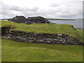
Iron Age and Later PrehistorySite Name: North Howe BrochCountry: Scotland County: Orkney Type: Broch or Nuraghe
Map Ref: HY3705130722
Latitude: 59.158569N Longitude: 3.102484W
Condition:
| 5 | Perfect |
| 4 | Almost Perfect |
| 3 | Reasonable but with some damage |
| 2 | Ruined but still recognisable as an ancient site |
| 1 | Pretty much destroyed, possibly visible as crop marks |
| 0 | No data. |
| -1 | Completely destroyed |
| 5 | Superb |
| 4 | Good |
| 3 | Ordinary |
| 2 | Not Good |
| 1 | Awful |
| 0 | No data. |
| 5 | Can be driven to, probably with disabled access |
| 4 | Short walk on a footpath |
| 3 | Requiring a bit more of a walk |
| 2 | A long walk |
| 1 | In the middle of nowhere, a nightmare to find |
| 0 | No data. |
| 5 | co-ordinates taken by GPS or official recorded co-ordinates |
| 4 | co-ordinates scaled from a detailed map |
| 3 | co-ordinates scaled from a bad map |
| 2 | co-ordinates of the nearest village |
| 1 | co-ordinates of the nearest town |
| 0 | no data |
Internal Links:
External Links:
I have visited· I would like to visit
PAB has visited here
")
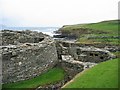
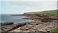
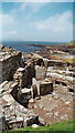
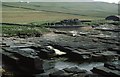
From details provided on Canmore about a Geophysical Survey in 2018, this can reasonably be recorded as the ruins of a broch, with associated features.
This photo was taken in June 2016, and the same feature can be seen on the Canmore site page. Full details of the site and the 2018 Geophysical Survey can be found on Canmore, and a summary of the Survey is given in the Comments below.
You may be viewing yesterday's version of this page. To see the most up to date information please register for a free account.
")
Do not use the above information on other web sites or publications without permission of the contributor.
Nearby Images from Geograph Britain and Ireland:
©2005(licence)
©2013(licence)
©2013(licence)
©2012(licence)
©2015(licence)
The above images may not be of the site on this page, they are loaded from Geograph.
Please Submit an Image of this site or go out and take one for us!
Click here to see more info for this site
Nearby sites
Key: Red: member's photo, Blue: 3rd party photo, Yellow: other image, Green: no photo - please go there and take one, Grey: site destroyed
Download sites to:
KML (Google Earth)
GPX (GPS waypoints)
CSV (Garmin/Navman)
CSV (Excel)
To unlock full downloads you need to sign up as a Contributory Member. Otherwise downloads are limited to 50 sites.
Turn off the page maps and other distractions
Nearby sites listing. In the following links * = Image available
192m SE 128° Midhowe Broch* Broch or Nuraghe (HY372306)
271m SE 141° Midhowe Chambered Cairn* Chambered Cairn (HY37223051)
981m SSE 163° Knowe of Rowiegar* Chambered Cairn (HY37332978)
1.2km SSE 155° Knowe of Swandro* Chambered Cairn (HY37532966)
1.5km NNE 13° Knowe of Dale* Misc. Earthwork (HY37423217)
2.2km SE 141° Westness Chambererd Tomb* Chambered Tomb (HY38402898)
3.1km ENE 56° Knowe of Lingro Cairn (HY3964832378)
3.4km SE 140° Viera Lodge Broch or Nuraghe (HY392281)
3.5km SSW 210° Burgar* Broch or Nuraghe (HY352277)
3.6km NE 41° Wasbister* Crannog (HY395334)
3.7km SW 217° West Broch of Burgar* Chambered Cairn (HY34822782)
3.7km NE 46° Bretta Ness* Ancient Village or Settlement (HY39723324)
3.7km SSW 201° Knowe of Grugar* Broch or Nuraghe (HY35642730)
3.9km WSW 238° Peterkirk* Broch or Nuraghe (HY337287)
4.0km SE 133° Knowe of Lairo* Chambered Cairn (HY39922796)
4.0km S 188° Knowe of Stenso* Broch or Nuraghe (HY3639426747)
4.0km SSE 163° Aikerness Class I Pictish Symbol Stone (HY38182685)
4.0km SE 131° Knowe of Ramsay* Chambered Cairn (HY40042800)
4.0km SSE 163° Gurness* Broch or Nuraghe (HY3818926842)
4.1km SSW 204° Grugar* Carving (HY353270)
4.4km SE 128° Knowe of Yarso* Chambered Cairn (HY40482795)
4.4km SE 137° Knowe of Burrian (Frotoft)* Broch or Nuraghe (HY40062745)
4.6km SE 133° Langstane (Orkney)* Standing Stone (Menhir) (HY404275)
5.0km E 80° Knowe of Craie* Chambered Cairn (HY41963153)
5.0km WSW 240° Vinquin* Broch or Nuraghe (HY32682830)
View more nearby sites and additional images


 We would like to know more about this location. Please feel free to add a brief description and any relevant information in your own language.
 Wir möchten mehr über diese Stätte erfahren. Bitte zögern Sie nicht, eine kurze Beschreibung und relevante Informationen in Deutsch hinzuzufügen.
 Nous aimerions en savoir encore un peu sur les lieux. S'il vous plaît n'hesitez pas à ajouter une courte description et tous les renseignements pertinents dans votre propre langue.
 Quisieramos informarnos un poco más de las lugares. No dude en añadir una breve descripción y otros datos relevantes en su propio idioma.