


<< Text Pages >> Aikerness - Class I Pictish Symbol Stone in Scotland in Orkney
Submitted by alligator on Monday, 24 March 2003 Page Views: 4732
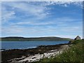
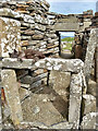
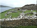
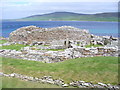
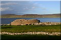
Early Medieval (Dark Age)Site Name: Aikerness Alternative Name: GurnessCountry: Scotland County: Orkney Type: Class I Pictish Symbol Stone
Map Ref: HY38182685 Landranger Map Number: 6
Latitude: 59.123970N Longitude: 3.081649W
Condition:
| 5 | Perfect |
| 4 | Almost Perfect |
| 3 | Reasonable but with some damage |
| 2 | Ruined but still recognisable as an ancient site |
| 1 | Pretty much destroyed, possibly visible as crop marks |
| 0 | No data. |
| -1 | Completely destroyed |
| 5 | Superb |
| 4 | Good |
| 3 | Ordinary |
| 2 | Not Good |
| 1 | Awful |
| 0 | No data. |
| 5 | Can be driven to, probably with disabled access |
| 4 | Short walk on a footpath |
| 3 | Requiring a bit more of a walk |
| 2 | A long walk |
| 1 | In the middle of nowhere, a nightmare to find |
| 0 | No data. |
| 5 | co-ordinates taken by GPS or official recorded co-ordinates |
| 4 | co-ordinates scaled from a detailed map |
| 3 | co-ordinates scaled from a bad map |
| 2 | co-ordinates of the nearest village |
| 1 | co-ordinates of the nearest town |
| 0 | no data |
Internal Links:
External Links:
Class I Pictish Symbol Stone in Orkney
For details, visit: http://www.archaeoptics.co.uk/products/ecms/273.html Update: Archaeoptics link may be out of date, information now available via the Canmore site. Visit: Canmore http://canmore.org.uk/site/2202
You may be viewing yesterday's version of this page. To see the most up to date information please register for a free account.
Do not use the above information on other web sites or publications without permission of the contributor.
Nearby Images from Geograph Britain and Ireland:
©2011(licence)
©2021(licence)
©2023(licence)
©2007(licence)
©2014(licence)
The above images may not be of the site on this page, they are loaded from Geograph.
Please Submit an Image of this site or go out and take one for us!
Click here to see more info for this site
Nearby sites
Key: Red: member's photo, Blue: 3rd party photo, Yellow: other image, Green: no photo - please go there and take one, Grey: site destroyed
Download sites to:
KML (Google Earth)
GPX (GPS waypoints)
CSV (Garmin/Navman)
CSV (Excel)
To unlock full downloads you need to sign up as a Contributory Member. Otherwise downloads are limited to 50 sites.
Turn off the page maps and other distractions
Nearby sites listing. In the following links * = Image available
12m SE 131° Gurness* Broch or Nuraghe (HY3818926842)
1.6km NE 38° Viera Lodge Broch or Nuraghe (HY392281)
1.8km W 266° Knowe of Stenso* Broch or Nuraghe (HY3639426747)
1.8km S 190° Quoys Chambered Cairn Chambered Cairn (HY37822507)
2.0km ENE 71° Knowe of Burrian (Frotoft)* Broch or Nuraghe (HY40062745)
2.0km S 184° Redland South* Chambered Cairn (HY38002484)
2.1km ENE 56° Knowe of Lairo* Chambered Cairn (HY39922796)
2.1km N 5° Westness Chambererd Tomb* Chambered Tomb (HY38402898)
2.2km ENE 57° Knowe of Ramsay* Chambered Cairn (HY40042800)
2.3km ENE 73° Langstane (Orkney)* Standing Stone (Menhir) (HY404275)
2.5km ENE 63° Knowe of Yarso* Chambered Cairn (HY40482795)
2.6km W 279° Knowe of Grugar* Broch or Nuraghe (HY35642730)
2.7km SE 135° Ness of Woodwick* Broch or Nuraghe (HY40072487)
2.9km W 272° Grugar* Carving (HY353270)
2.9km NNW 346° Knowe of Swandro* Chambered Cairn (HY37532966)
3.0km NNW 343° Knowe of Rowiegar* Chambered Cairn (HY37332978)
3.1km WNW 285° Burgar* Broch or Nuraghe (HY352277)
3.3km E 83° Knowe of Hunclett* Broch or Nuraghe (HY41442722)
3.3km ENE 76° Blackhammer* Chambered Tomb (HY41422761)
3.5km WNW 285° West Broch of Burgar* Chambered Cairn (HY34822782)
3.6km SSE 152° Knowe of Midgarth* Ancient Village or Settlement (HY39812361)
3.8km NNW 344° Midhowe Chambered Cairn* Chambered Cairn (HY37223051)
3.9km NNW 344° Midhowe Broch* Broch or Nuraghe (HY372306)
4.0km NNW 343° North Howe Broch* Broch or Nuraghe (HY3705130722)
4.4km E 79° Taversoe Tuick* Chambered Cairn (HY42572761)
View more nearby sites and additional images


 We would like to know more about this location. Please feel free to add a brief description and any relevant information in your own language.
 Wir möchten mehr über diese Stätte erfahren. Bitte zögern Sie nicht, eine kurze Beschreibung und relevante Informationen in Deutsch hinzuzufügen.
 Nous aimerions en savoir encore un peu sur les lieux. S'il vous plaît n'hesitez pas à ajouter une courte description et tous les renseignements pertinents dans votre propre langue.
 Quisieramos informarnos un poco más de las lugares. No dude en añadir una breve descripción y otros datos relevantes en su propio idioma.