<< Our Photo Pages >> Birch Tor Cairn - Cairn in England in Devon
Submitted by Bladup on Tuesday, 29 October 2013 Page Views: 2269
Neolithic and Bronze AgeSite Name: Birch Tor Cairn Alternative Name: Birch Tor Summit; Grinsell (North Bovey 1)Country: England County: Devon Type: Cairn
Nearest Town: Moretonhampstead Nearest Village: Postbridge / Lettaford
Map Ref: SX6868681654
Latitude: 50.619767N Longitude: 3.85762W
Condition:
| 5 | Perfect |
| 4 | Almost Perfect |
| 3 | Reasonable but with some damage |
| 2 | Ruined but still recognisable as an ancient site |
| 1 | Pretty much destroyed, possibly visible as crop marks |
| 0 | No data. |
| -1 | Completely destroyed |
| 5 | Superb |
| 4 | Good |
| 3 | Ordinary |
| 2 | Not Good |
| 1 | Awful |
| 0 | No data. |
| 5 | Can be driven to, probably with disabled access |
| 4 | Short walk on a footpath |
| 3 | Requiring a bit more of a walk |
| 2 | A long walk |
| 1 | In the middle of nowhere, a nightmare to find |
| 0 | No data. |
| 5 | co-ordinates taken by GPS or official recorded co-ordinates |
| 4 | co-ordinates scaled from a detailed map |
| 3 | co-ordinates scaled from a bad map |
| 2 | co-ordinates of the nearest village |
| 1 | co-ordinates of the nearest town |
| 0 | no data |
Internal Links:
External Links:
I have visited· I would like to visit
heidavey has visited here
")
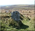
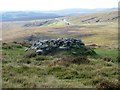
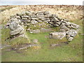
The centre and S margin of this feature have apparently suffered from an unrecorded excavation with spoil dumped to the S and on the E fringe of the mound. Two large upright slabs are embedded in the unexcavated interior of the cairn.
This cairn also features on the Prehistoric Dartmoor Walks (PDW) website - see their entry for the Birch Tor Cairn, which tells us the cairn (which they record as measuring 17.0 x 2.0m) has been heavily disturbed.
The cairn is also recorded as Pastscape Monument No. 443799 and scheduled as Historic England List ID 1021341 (Round cairn and Headland Warrant boundary stone 210m north of Birch Tor).
You may be viewing yesterday's version of this page. To see the most up to date information please register for a free account.
")
Do not use the above information on other web sites or publications without permission of the contributor.
Nearby Images from Geograph Britain and Ireland:
©2021(licence)
©2005(licence)
©2018(licence)
©2008(licence)
![SX6881 : The view from the crest [2] by Michael Dibb](https://s2.geograph.org.uk/geophotos/05/93/74/5937462_7b5f23f9_120x120.jpg)
©2018(licence)
The above images may not be of the site on this page, they are loaded from Geograph.
Please Submit an Image of this site or go out and take one for us!
Click here to see more info for this site
Nearby sites
Key: Red: member's photo, Blue: 3rd party photo, Yellow: other image, Green: no photo - please go there and take one, Grey: site destroyed
Download sites to:
KML (Google Earth)
GPX (GPS waypoints)
CSV (Garmin/Navman)
CSV (Excel)
To unlock full downloads you need to sign up as a Contributory Member. Otherwise downloads are limited to 50 sites.
Turn off the page maps and other distractions
Nearby sites listing. In the following links * = Image available
554m NNW 338° Bush Down Settlement* Ancient Village or Settlement (SX6849282173)
685m W 266° Bennet's Cross* Ancient Cross (SX68008162)
837m ENE 60° Shapley Common Ancient Village or Settlement (SX69428206)
868m SSE 160° Challacombe Down Cairn Circle* Cairn (SX68968083)
884m SSE 159° Challacombe rows* Multiple Stone Rows / Avenue (SX68988082)
991m SSE 159° Challacombe Down Standing Stone* Standing Stone (Menhir) (SX69028072)
1.3km ESE 104° Hookney Tor Cairn* Cairn (SX6990281310)
1.6km ESE 117° Grimspound* Ancient Village or Settlement (SX70078090)
1.6km WSW 255° Water hill cairn* Cairn (SX67158128)
1.6km NW 314° Chagford Common Cairn* Cairn (SX6757182800)
1.6km WNW 301° Hurston Ridge Settlement* Ancient Village or Settlement (SX67338253)
1.6km WNW 300° Hurston Ridge* Multiple Stone Rows / Avenue (SX67308251)
1.8km ESE 104° Grimslake Cist* Cairn (SX7041881165)
1.8km NE 35° Challacombe Cross Settlement* Ancient Village or Settlement (SX69788313)
1.9km ESE 122° Hamel Down Platform Cairn (North)* Cairn (SX70318057)
2.0km SSW 210° Soussons Down Stone Row Multiple Stone Rows / Avenue (SX6767079980)
2.2km SSW 205° Soussons Down Cairns* Barrow Cemetery (SX6770079671)
2.3km NE 41° Leeper Cross* Ancient Cross (SX7022083325)
2.3km SE 130° Hamel Down Cross* Ancient Cross (SX70428011)
2.6km SE 132° Broad Barrow (Hamel Down)* Round Barrow(s) (SX70577990)
2.6km NW 322° The Heath Stone* Standing Stone (Menhir) (SX6712083750)
2.8km WNW 289° Assycombe Hill* Cairn (SX66108264)
2.8km WNW 288° Assycombe* Multiple Stone Rows / Avenue (SX66058260)
2.8km SE 137° Single Barrow (Hamel Down)* Round Barrow(s) (SX70577953)
2.9km SE 137° Hamel Down* Barrow Cemetery (SX706795)
View more nearby sites and additional images


 We would like to know more about this location. Please feel free to add a brief description and any relevant information in your own language.
 Wir möchten mehr über diese Stätte erfahren. Bitte zögern Sie nicht, eine kurze Beschreibung und relevante Informationen in Deutsch hinzuzufügen.
 Nous aimerions en savoir encore un peu sur les lieux. S'il vous plaît n'hesitez pas à ajouter une courte description et tous les renseignements pertinents dans votre propre langue.
 Quisieramos informarnos un poco más de las lugares. No dude en añadir una breve descripción y otros datos relevantes en su propio idioma.