Featured: Hare and Tabor T Shirts for discerning antiquarians

Hare and Tabor T Shirts for discerning antiquarians

John Michell: From Atlantis to Avalon

John Michell: From Atlantis to Avalon

Who's Online

There are currently, 217 guests and 1 members online.

You are a guest. To join in, please register for free by clicking here

Sponsors

<< Our Photo Pages >> The Longstone (Piles Hill) - Standing Stone (Menhir) in England in Devon

Submitted by TheCaptain on Monday, 28 March 2022  Page Views: 7805

Neolithic and Bronze AgeSite Name: The Longstone (Piles Hill)
Country: England County: Devon Type: Standing Stone (Menhir)
Nearest Town: Ivybridge
Map Ref: SX65436074
Latitude: 50.431048N  Longitude: 3.896069W
Condition:
5Perfect
4Almost Perfect
3Reasonable but with some damage
2Ruined but still recognisable as an ancient site
1Pretty much destroyed, possibly visible as crop marks
0No data.
-1Completely destroyed
4 Ambience:
5Superb
4Good
3Ordinary
2Not Good
1Awful
0No data.
4 Access:
5Can be driven to, probably with disabled access
4Short walk on a footpath
3Requiring a bit more of a walk
2A long walk
1In the middle of nowhere, a nightmare to find
0No data.
3 Accuracy:
5co-ordinates taken by GPS or official recorded co-ordinates
4co-ordinates scaled from a detailed map
3co-ordinates scaled from a bad map
2co-ordinates of the nearest village
1co-ordinates of the nearest town
0no data
5

Internal Links:
External Links:

I have visited· I would like to visit

Catrinm visited on 14th Apr 2024 - their rating: Cond: 3 Amb: 4 Access: 3 Re erected long stone on the way to Piles Hill. Great views if you get a clear day

Catrinm visited on 1st Oct 2023 - their rating: Cond: 4 Amb: 4 Access: 3

Catrinm visited on 27th Sep 2020 - their rating: Cond: 3 Amb: 3 Access: 2

SandyG visited on 9th Mar 2013 - their rating: Cond: 3 Amb: 5 Access: 3 Car parking is available at SX 64338 59550.

TheCaptain cazzyjane have visited here

Average ratings for this site from all visit loggers: Condition: 3.25 Ambience: 4 Access: 2.75
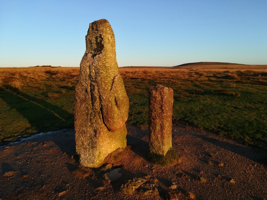
The Longstone (Piles Hill)
The Longstone (Piles Hill) submitted by Bladup : The Longstone (Piles Hill) (Vote or comment on this photo)
This large pointy topped stone just below the summit of Piles Hill, over 2 metres in height, leans at an angle although it has been only recently re-erected. It probably marked the northern end of the Butterdon Hill stone row.

Besides this pillar is a more modern boundary stone, which was placed there as a marker as the original longstone had fallen.

Update November 2019: This standing stone is recorded as Pastscape Monument No. 441919, which adds: "To its northeast side there is a boundary stone erected in 1803 and shaped by drilling. It is of identical stone and appears to have been fashioned from the 'Longstone' which would therefore have originally been some 4.5m long".

The stone is also included as MDV5653 (The Longstone on the Butterdon Stone Row) on the Devon and Dartmoor HER, and scheduled as part of Historic England List Entry No. 1012486 (Butterdon Hill stone alignment and cairn).

The stone also features on Prehistoric Dartmoor Walks - see their entries for the Piles Hill Standing Stone and the Piles Hill Double Stone Row and Cairns page.

Note: New research by John Aylett into visual and astronomical links at Piles Hill stone row on Dartmoor, more in the comments on our page here and in our forum
You may be viewing yesterday's version of this page. To see the most up to date information please register for a free account.


The Longstone (Piles Hill)
The Longstone (Piles Hill) submitted by Bladup : Sunrise at the Longstone (Piles Hill) (Vote or comment on this photo)

The Longstone (Piles Hill)
The Longstone (Piles Hill) submitted by cazzyjane : The Longstone, with a wintry weather heading it's way. (2 comments - Vote or comment on this photo)

The Longstone (Piles Hill)
The Longstone (Piles Hill) submitted by cazzyjane : The Longstone and marker. April 2012. (2 comments - Vote or comment on this photo)

The Longstone (Piles Hill)
The Longstone (Piles Hill) submitted by Bladup : The Longstone (Piles Hill) with Butterdon Hill cairns in the background (Vote or comment on this photo)

The Longstone (Piles Hill)
The Longstone (Piles Hill) submitted by John_A : Summer solstice sunrise at the Longstone on Piles Hill Dartmoor. 22nd June 2023.

The Longstone (Piles Hill)
The Longstone (Piles Hill) submitted by Bladup : The Longstone (Piles Hill)

The Longstone (Piles Hill)
The Longstone (Piles Hill) submitted by Bladup : The Longstone (Piles Hill) with Ugborough Beacon in the background

The Longstone (Piles Hill)
The Longstone (Piles Hill) submitted by Bladup : The Longstone (Piles Hill)

The Longstone (Piles Hill)
The Longstone (Piles Hill) submitted by SandyG : The Longstone and friend. The stone on the right is a later boundary marker. There is a history of legal disputes concerning this boundary and the new stone will have been erected to resolve one of these. A remarkable juxtaposition of stones with many stories to tell.

The Longstone (Piles Hill)
The Longstone (Piles Hill) submitted by thecaptain : Besides this pillar is a more modern boundary stone, which was probably placed there as a marker as the original longstone had fallen.

The Longstone (Piles Hill)
The Longstone (Piles Hill) submitted by thecaptain : This large stone just below the summit of Piles Hill, over 2 metres in height, leans at an angle although it has been only recently re-erected. It probably marked the northern end of the Butterdon Hill stone row.

The Longstone (Piles Hill)
The Longstone (Piles Hill) submitted by thecaptain : This is a view looking to the south, along the full 2km length of the Butterdon Hill stone row. Butterdon Hill with its two large cairns, where the row starts, is on the horizon. Butterdon Hill Barrow, where the row reaches the top of the ridge and changes direction can also just be made out, midway between the top of the longstone and the left hand cairn.

The Longstone (Piles Hill)
The Longstone (Piles Hill) submitted by thecaptain : This large stone probably marked the northern end of the Butterdon Hill stone row.

Do not use the above information on other web sites or publications without permission of the contributor.
Click here to see more info for this site

Nearby sites

Click here to view sites on an interactive OS map

Key: Red: member's photo, Blue: 3rd party photo, Yellow: other image, Green: no photo - please go there and take one, Grey: site destroyed

Download sites to:
KML (Google Earth)
GPX (GPS waypoints)
CSV (Garmin/Navman)
CSV (Excel)

To unlock full downloads you need to sign up as a Contributory Member. Otherwise downloads are limited to 50 sites.


Turn off the page maps and other distractions

Nearby sites listing. In the following links * = Image available
 206m NW 320° Piles Hill Cairns* Cairn (SX653609)
 281m SSE 162° Hobajons Cross* Standing Stone (Menhir) (SX65516047)
 434m SE 134° Glasscombe Ball North* Stone Row / Alignment (SX6573360429)
 442m SE 126° Glasscombe Ball North (North Cairn)* Cairn (SX6578360473)
 445m SE 136° Glasscombe Ball North (South Cairn)* Cairn (SX65736041)
 526m SSE 167° Butterdon Hill Row* Stone Row / Alignment (SX6553960225)
 529m NW 313° Piles Hill W* Multiple Stone Rows / Avenue (SX65056111)
 582m NE 49° Piles Hill NE* Multiple Stone Rows / Avenue (SX65886111)
 586m E 98° Glasscombe Corner SW Terminal Cairn* Cairn (SX6601060646)
 586m E 93° Glasscombe Corner Stone Row* Stone Row / Alignment (SX6601660691)
 671m E 83° Glasscombe Ball NE* Multiple Stone Rows / Avenue (SX6610060802)
 871m SSW 194° Butterbrook* Stone Row / Alignment (SX652599)
 902m SSW 200° Harford Moor N* Stone Row / Alignment (SX651599)
 906m SSE 147° Spurrell's Cross* Ancient Cross (SX65915997)
 936m SSE 153° Spurrells Cross Row* Multiple Stone Rows / Avenue (SX6583759896)
 974m SSE 153° Spurrell's Cross Row Terminal Cairn Cairn (SX6585859864)
 996m SSW 198° Harford S.* Multiple Stone Rows / Avenue (SX651598)
 1.0km SSE 157° Spurrells Cross Cairn Circle* Stone Circle (SX658598)
 1.0km WSW 240° Lower Piles* Ring Cairn (SX6453660255)
 1.1km ENE 59° Upper Glazebrook* Ancient Village or Settlement (SX66366126)
 1.1km WSW 255° Lower Piles Enclosed Settlement Ancient Village or Settlement (SX64376048)
 1.1km E 101° Lower Glasscombe* Cist (SX6650660502)
 1.1km NNW 336° Sharp Tor cairn* Cairn (SX65006179)
 1.2km NNW 338° Sharp Tor North East* Stone Row / Alignment (SX65006188)
 1.2km ENE 68° Corringdon Ball* Multiple Stone Rows / Avenue (SX6660761169)
View more nearby sites and additional images

<< Ugborough Beacon Propped Stone

Pont Yr Afon Hut Circle >>

Please add your thoughts on this site

Prehistoric Settlements

Prehistoric Settlements

Sponsors

Auto-Translation (Google)

Translate from English into:

"The Longstone (Piles Hill)" | Login/Create an Account | 5 News and Comments
  
Go back to top of page    Comments are owned by the poster. We aren't responsible for their content.
New research on visual and astronomical links by Andy B on Monday, 28 March 2022
(User Info | Send a Message)
Sandy Gerrard writes: A new research article looking at various visual and astronomical links has been added to our website. The article is written by John Aylett who has conducted original work at the Piles Hill stone row on Dartmoor and has discovered a number of significant links between the stone row, nearby Longstone other broadly contemporary sites in the area combined with significant astronomical connections. The results of work are well worth looking at and John would be very grateful for feedback on his observations and ideas.

Please view the article here.
https://stonerows.files.wordpress.com/2021/11/the-longstone-and-avenue-on-piles-hill-dartmoor.pdf

Source:
https://stonerows.wordpress.com/2021/11/09/fresh-research-at-piles-hill-stone-row-on-dartmoor/
[ Reply to This ]

Re: The Longstone (Piles Hill) by Anonymous on Sunday, 11 February 2018
Apparently it has fallen over again
[ Reply to This ]

Re: The Longstone (Piles Hill) by Anonymous on Monday, 07 January 2008
North of the longstone is perhaps one of Dartmoors most interesting monuments, which itself may hold the key to interpreting the stone rows on Dartmoor. Its known as the Piles Hill Avenue. It is labelled on the O.S map running East to West for about 1km. This was no trivial monument, indeed it was the most impressive of all the rows on Dartmoor, sporting two lines of Massive stones, most of which are fallen. On the ground its very hard to find, but once you are on it you can follow the line of fallen stones.

The disatnce between the two lines varies but reaches 20 m at the most, which makes this the widest of all the double rows. The two ends of the avenue are not at the highest point of the hill, rather they are set down halfway on each side of the broad back of the hill. The highest point is in the centre, at a point where a trackway and old tramway cross through. Its better to describe this as an avenue rather than a double row, as its compares better to the avenues at Avebury and Stanton Drew.

A mystery remains however, there is no stone circle or cairn to which the row orientates. Bothe ends of the row are closed by a line of fallen stones. Not like the blocking stones elsewhere, but rather more like the way in which a cursus ends, or begins. The eastern end is blocked by a long cairn of stones, into which some larger stones were once placed.

The likely point for a stone circle would be the centre of the avenue, at the crest of the hill. Here there is a notable gap in the two rows, where many stones have been robbed, some split into smaller fragmests. The ground here has also been disturbed not only by the tramway and track, but also by various pits and trenches. If anything had once existed here, its now dissapeared.
However arial shots of the location indicate a dark green ring mark, faintly visable. It measures about 30 m wide, and is slightly egg-shaped. Could this be the site of a missing stone circle? If so it could be the singlemost important site on dartmoor. The reason is that none of the early stone circles on dartmoor possess an avenue, or a row. They do possess entrances, like that at Sourton, or Sherberton. But no avenue has ever been found connected to any of them.

The stone circles predated the rows, for sure, so if there was a avenue at Piles hill and it lead up to a Stone circle, then the mystery of the Dartmoor stone rows is solved. As surely all the later rows and their small circle/cairns were simply imitations of this great monument.

The state of this avenue has led to its existence being largely overlooked, as well as its significance.

The ringmark is visible on google earth, so take a look for your selves.
[ Reply to This ]
    Re: The Longstone (Piles Hill) by TheCaptain on Monday, 07 January 2008
    (User Info | Send a Message)
    We have details of the wonderful Piles Hill avenue here on the Megalithic Portal, under the name Piles Hill NE, with a few pictures of the western terminal under the name Piles Hill W. Check out those pages.

    I cannot at the moment remember why the avenue seems to be split into two site pages, this is probably something to do with the original source from Burl. I will at some point try and tidy up these two site pages under the name Piles Hill Avenue.
    [ Reply to This ]

Re: The Longstone (Piles Hill) by simonsworn on Tuesday, 15 March 2005
(User Info | Send a Message)
This standing stone at the northern end of Butterdon Row marks the present terminus. The row itself changes course several times, possibly representing various phases of construction, the final kink to meet this stone suggests that the stone may have been present before the row was constructed, or that this is a later alteration and the original row terminated at a cairn that sits some 50m futher north.
[ Reply to This ]

Your Name: Anonymous [ Register Now ]
Subject:


Add your comment or contribution to this page. Spam or offensive posts are deleted immediately, don't even bother

<<< What is five plus one as a number? (Please type the answer to this question in the little box on the left)
You can also embed videos and other things. For Youtube please copy and paste the 'embed code'.
For Google Street View please include Street View in the text.
Create a web link like this: <a href="https://www.megalithic.co.uk">This is a link</a>  

Allowed HTML is:
<p> <b> <i> <a> <img> <em> <br> <strong> <blockquote> <tt> <li> <ol> <ul> <object> <param> <embed> <iframe>

We would like to know more about this location. Please feel free to add a brief description and any relevant information in your own language.
Wir möchten mehr über diese Stätte erfahren. Bitte zögern Sie nicht, eine kurze Beschreibung und relevante Informationen in Deutsch hinzuzufügen.
Nous aimerions en savoir encore un peu sur les lieux. S'il vous plaît n'hesitez pas à ajouter une courte description et tous les renseignements pertinents dans votre propre langue.
Quisieramos informarnos un poco más de las lugares. No dude en añadir una breve descripción y otros datos relevantes en su propio idioma.