<< Our Photo Pages >> Pont Scethin Double Cairn - Cairn in Wales in Gwynedd
Submitted by TimPrevett on Tuesday, 18 September 2007 Page Views: 4171
Neolithic and Bronze AgeSite Name: Pont Scethin Double CairnCountry: Wales County: Gwynedd Type: Cairn
Nearest Town: Barmouth
Map Ref: SH62902386
Latitude: 52.794834N Longitude: 4.034774W
Condition:
| 5 | Perfect |
| 4 | Almost Perfect |
| 3 | Reasonable but with some damage |
| 2 | Ruined but still recognisable as an ancient site |
| 1 | Pretty much destroyed, possibly visible as crop marks |
| 0 | No data. |
| -1 | Completely destroyed |
| 5 | Superb |
| 4 | Good |
| 3 | Ordinary |
| 2 | Not Good |
| 1 | Awful |
| 0 | No data. |
| 5 | Can be driven to, probably with disabled access |
| 4 | Short walk on a footpath |
| 3 | Requiring a bit more of a walk |
| 2 | A long walk |
| 1 | In the middle of nowhere, a nightmare to find |
| 0 | No data. |
| 5 | co-ordinates taken by GPS or official recorded co-ordinates |
| 4 | co-ordinates scaled from a detailed map |
| 3 | co-ordinates scaled from a bad map |
| 2 | co-ordinates of the nearest village |
| 1 | co-ordinates of the nearest town |
| 0 | no data |
Internal Links:
External Links:
I have visited· I would like to visit
w650marion visited on 5th Jul 2022 - their rating: Cond: 1 Amb: 4 Access: 3 Coflein led me to believe that there were four mounds from a bronze age cemetery nearby on this side of the road. I don’t believe it! I think the aerial mapping project just saw a trick of the light, and invented them!
w650marion have visited here
")
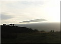
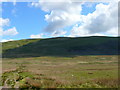
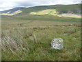
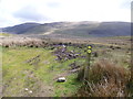
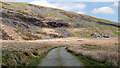
A cairn west from Pont Scethin, which Coflein records as a 'double cairn'.
You may be viewing yesterday's version of this page. To see the most up to date information please register for a free account.
")
")
")
Do not use the above information on other web sites or publications without permission of the contributor.
Nearby Images from Geograph Britain and Ireland:
©2008(licence)
©2011(licence)
©2011(licence)
©2015(licence)
©2019(licence)
The above images may not be of the site on this page, they are loaded from Geograph.
Please Submit an Image of this site or go out and take one for us!
Click here to see more info for this site
Nearby sites
Key: Red: member's photo, Blue: 3rd party photo, Yellow: other image, Green: no photo - please go there and take one, Grey: site destroyed
Download sites to:
KML (Google Earth)
GPX (GPS waypoints)
CSV (Garmin/Navman)
CSV (Excel)
To unlock full downloads you need to sign up as a Contributory Member. Otherwise downloads are limited to 50 sites.
Turn off the page maps and other distractions
Nearby sites listing. In the following links * = Image available
219m SSW 208° Pont Scethin B* Standing Stone (Menhir) (SH62792367)
278m SW 216° Pont Scethin A* Standing Stone (Menhir) (SH62732364)
468m SW 218° Cairns North of Craig Y Dinas* Cairn (SH626235)
775m NNW 336° Moelfre (Gwynedd)* Round Cairn (SH62612458)
890m SE 136° Enclosure and Hut Circle, Pont Scethin* Ancient Village or Settlement (SH63502320)
899m W 272° Hut Group and Enclosures on SW Slope of Moelfre* Ancient Village or Settlement (SH62002391)
957m SSW 197° Hut Circle Settlement East of Craig Y Dinas* Ancient Village or Settlement (SH62602295)
979m SSW 207° Craig-y-Dinas (Dyffryn Ardudwy)* Hillfort (SH62432300)
1.2km WSW 257° Cors Uchaf E Hut Group* Ancient Village or Settlement (SH61682361)
1.3km SW 234° Craig-y-Dinas W* Cairn (SH61852315)
1.6km SSW 194° Llyn Irddyn W* Ancient Village or Settlement (SH62462229)
1.7km SSW 201° Tumulus, Llyn Irddyn* Round Barrow(s) (SH62232225)
1.8km WSW 250° Cors Uchaf S* Cairn (SH61232330)
1.8km WSW 242° Cors-Y-Gedol E* Cairn (SH61252305)
2.0km W 272° Waun Hir* Ring Cairn (SH609240)
2.1km WSW 242° Hut Circle, N of Afon Ysgethin* Ancient Village or Settlement (SH61062293)
2.1km N 350° Cwm Nantcol Tumuli* Cairn (SH626259)
2.1km WNW 301° Bron Y Foel Recumbent Stone* Portal Tomb (SH611250)
2.1km SSW 207° Llyn Irddyn Hut Circle* Cairn (SH61862198)
2.2km W 277° Romano British Homestead with Enclosure, Dyffryn Ardudwy* Ancient Village or Settlement (SH60762420)
2.2km SW 225° Ponfadog Bridge* Natural Stone / Erratic / Other Natural Feature (SH61312235)
2.2km WNW 288° Bron y Foel Isaf* Portal Tomb (SH608246)
2.3km NW 316° Ffynnon Enddwyn* Holy Well or Sacred Spring (SH61372552)
2.3km WSW 239° Pont Fadog N Hut Circles* Ancient Village or Settlement (SH60842272)
2.5km SW 221° Cairns SE from Pont Fadog* Cairn (SH612220)
View more nearby sites and additional images


 We would like to know more about this location. Please feel free to add a brief description and any relevant information in your own language.
 Wir möchten mehr über diese Stätte erfahren. Bitte zögern Sie nicht, eine kurze Beschreibung und relevante Informationen in Deutsch hinzuzufügen.
 Nous aimerions en savoir encore un peu sur les lieux. S'il vous plaît n'hesitez pas à ajouter une courte description et tous les renseignements pertinents dans votre propre langue.
 Quisieramos informarnos un poco más de las lugares. No dude en añadir una breve descripción y otros datos relevantes en su propio idioma.