<< Our Photo Pages >> Pont Fadog W Hut Circle - Ancient Village or Settlement in Wales in Gwynedd
Submitted by w650marion on Monday, 06 April 2020 Page Views: 1999
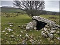
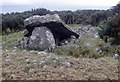
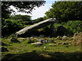
Multi-periodSite Name: Pont Fadog W Hut Circle Alternative Name: Hut Circle, Lletty LloegrCountry: Wales
NOTE: This site is 1.0 km away from the location you searched for.
County: Gwynedd Type: Ancient Village or Settlement
Nearest Town: Dyffryn Ardudwy
Map Ref: SH60392265
Latitude: 52.783320N Longitude: 4.071456W
Condition:
| 5 | Perfect |
| 4 | Almost Perfect |
| 3 | Reasonable but with some damage |
| 2 | Ruined but still recognisable as an ancient site |
| 1 | Pretty much destroyed, possibly visible as crop marks |
| 0 | No data. |
| -1 | Completely destroyed |
| 5 | Superb |
| 4 | Good |
| 3 | Ordinary |
| 2 | Not Good |
| 1 | Awful |
| 0 | No data. |
| 5 | Can be driven to, probably with disabled access |
| 4 | Short walk on a footpath |
| 3 | Requiring a bit more of a walk |
| 2 | A long walk |
| 1 | In the middle of nowhere, a nightmare to find |
| 0 | No data. |
| 5 | co-ordinates taken by GPS or official recorded co-ordinates |
| 4 | co-ordinates scaled from a detailed map |
| 3 | co-ordinates scaled from a bad map |
| 2 | co-ordinates of the nearest village |
| 1 | co-ordinates of the nearest town |
| 0 | no data |
Internal Links:
External Links:
")
Coflein calls it the Pont Fadog Hut Circle
Gwynedd Archaeological Trust calls it Hut Circle, Lletty Lloegr (the name of the house by Pont Fadog)
It is on the large scheduled monument ME128 which says "extensive multi-period settlement site with funerary monuments dating from the Neolithic period onwards"
You may be viewing yesterday's version of this page. To see the most up to date information please register for a free account.
")
")
")
Do not use the above information on other web sites or publications without permission of the contributor.
Nearby Images from Geograph Britain and Ireland:
©2020(licence)
©2012(licence)
©2006(licence)
©2020(licence)
©2020(licence)
The above images may not be of the site on this page, they are loaded from Geograph.
Please Submit an Image of this site or go out and take one for us!
Click here to see more info for this site
Nearby sites
Key: Red: member's photo, Blue: 3rd party photo, Yellow: other image, Green: no photo - please go there and take one, Grey: site destroyed
Download sites to:
KML (Google Earth)
GPX (GPS waypoints)
CSV (Garmin/Navman)
CSV (Excel)
To unlock full downloads you need to sign up as a Contributory Member. Otherwise downloads are limited to 50 sites.
Turn off the page maps and other distractions
Nearby sites listing. In the following links * = Image available
180m NNW 339° Cors y Gedol* Chambered Tomb (SH60332282)
186m NE 35° Cors Y Gedol Field System* Ancient Village or Settlement (SH605228)
390m N 357° Cors-y-Gedol Settlement* Ancient Village or Settlement (SH60382304)
454m E 79° Pont Fadog N Hut Circles* Ancient Village or Settlement (SH60842272)
724m ENE 66° Hut Circle, N of Afon Ysgethin* Ancient Village or Settlement (SH61062293)
946m ENE 63° Cors-Y-Gedol E* Cairn (SH61252305)
965m ESE 106° Ponfadog Bridge* Natural Stone / Erratic / Other Natural Feature (SH61312235)
1.0km SE 127° Cairns SE from Pont Fadog* Cairn (SH612220)
1.1km NE 51° Cors Uchaf S* Cairn (SH61232330)
1.2km SE 140° Llecheiddior* Stone Circle (SH61112174)
1.4km NNE 19° Waun Hir* Ring Cairn (SH609240)
1.5km W 277° Hut Circles and Field System, Dyffryn Ardudwy* Ancient Village or Settlement (SH58912287)
1.5km W 275° Dyffryn Ardudwy* Portal Tomb (SH58862284)
1.5km ENE 69° Craig-y-Dinas W* Cairn (SH61852315)
1.6km NNE 12° Romano British Homestead with Enclosure, Dyffryn Ardudwy* Ancient Village or Settlement (SH60762420)
1.6km NE 52° Cors Uchaf E Hut Group* Ancient Village or Settlement (SH61682361)
1.6km ESE 113° Llyn Irddyn Hut Circle* Cairn (SH61862198)
1.6km NNW 330° Byrllysg Promontory Fort* Promontory Fort / Cliff Castle (SH596241)
1.8km SSE 168° Pen-y-Dinas (Gwynedd)* Hillfort (SH607209)
1.8km SE 136° Ffridd Newydd* Stone Circle (SH61642129)
1.9km S 184° Cae'r Llwyn Homestead* Ancient Village or Settlement (SH602208)
1.9km E 101° Tumulus, Llyn Irddyn* Round Barrow(s) (SH62232225)
2.0km N 10° Bron y Foel Isaf* Portal Tomb (SH608246)
2.0km SSW 195° Hendre Eirian Hut Circles* Ancient Village or Settlement (SH598207)
2.0km NE 50° Hut Group and Enclosures on SW Slope of Moelfre* Ancient Village or Settlement (SH62002391)
View more nearby sites and additional images
Tutankhamun: Treasures of the Golden Pharaoh exhibition, Saatchi Gallery >>

")
 We would like to know more about this location. Please feel free to add a brief description and any relevant information in your own language.
 Wir möchten mehr über diese Stätte erfahren. Bitte zögern Sie nicht, eine kurze Beschreibung und relevante Informationen in Deutsch hinzuzufügen.
 Nous aimerions en savoir encore un peu sur les lieux. S'il vous plaît n'hesitez pas à ajouter une courte description et tous les renseignements pertinents dans votre propre langue.
 Quisieramos informarnos un poco más de las lugares. No dude en añadir una breve descripción y otros datos relevantes en su propio idioma.