


<< Our Photo Pages >> Windbury Head Fort - Hillfort in England in Devon
Submitted by Bladup on Sunday, 19 May 2024 Page Views: 763
Iron Age and Later PrehistorySite Name: Windbury Head FortCountry: England
NOTE: This site is 5.5 km away from the location you searched for.
County: Devon Type: Hillfort
Map Ref: SS28612658
Latitude: 51.012994N Longitude: 4.44465W
Condition:
| 5 | Perfect |
| 4 | Almost Perfect |
| 3 | Reasonable but with some damage |
| 2 | Ruined but still recognisable as an ancient site |
| 1 | Pretty much destroyed, possibly visible as crop marks |
| 0 | No data. |
| -1 | Completely destroyed |
| 5 | Superb |
| 4 | Good |
| 3 | Ordinary |
| 2 | Not Good |
| 1 | Awful |
| 0 | No data. |
| 5 | Can be driven to, probably with disabled access |
| 4 | Short walk on a footpath |
| 3 | Requiring a bit more of a walk |
| 2 | A long walk |
| 1 | In the middle of nowhere, a nightmare to find |
| 0 | No data. |
| 5 | co-ordinates taken by GPS or official recorded co-ordinates |
| 4 | co-ordinates scaled from a detailed map |
| 3 | co-ordinates scaled from a bad map |
| 2 | co-ordinates of the nearest village |
| 1 | co-ordinates of the nearest town |
| 0 | no data |
Internal Links:
External Links:
")
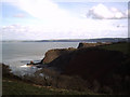
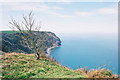
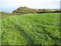
Windbury Head Fort Internally measures 120 metres east-west and 40 metres north-south but originally it was perhaps double this size. Now eroded by cliff-slip. It is univallate, though the rampart now appears as a scarp 7 metres wide, up to 2 metres high, with a poorly defined terrace 4 - 6 metres wide representing the former ditch. There is an overgrowth inturning at SS28672660 in the south east. This is possibly an original entrance, The substantial earthworks define a sub-rectangular area adjacent to the cliff edge.
You may be viewing yesterday's version of this page. To see the most up to date information please register for a free account.
")
")
")
Do not use the above information on other web sites or publications without permission of the contributor.
Nearby Images from Geograph Britain and Ireland:
©2005(licence)
©2005(licence)
©2016(licence)
©2016(licence)
©2005(licence)
The above images may not be of the site on this page, they are loaded from Geograph.
Please Submit an Image of this site or go out and take one for us!
Click here to see more info for this site
Nearby sites
Key: Red: member's photo, Blue: 3rd party photo, Yellow: other image, Green: no photo - please go there and take one, Grey: site destroyed
Download sites to:
KML (Google Earth)
GPX (GPS waypoints)
CSV (Garmin/Navman)
CSV (Excel)
To unlock full downloads you need to sign up as a Contributory Member. Otherwise downloads are limited to 50 sites.
Turn off the page maps and other distractions
Nearby sites listing. In the following links * = Image available
4.0km SE 139° Clovelly Dykes* Hillfort (SS311235)
4.6km SW 232° St Leonard's Well (Hartland)* Holy Well or Sacred Spring (SS2486423870)
4.9km SSW 213° St Clare's Well* Holy Well or Sacred Spring (SS2582422541)
5.3km WSW 247° St Nectan's Well (Stoke)* Holy Well or Sacred Spring (SS2363624683)
5.4km WSW 248° Stoke Churchyard Cross* Ancient Cross (SS235247)
6.8km SSW 200° Bursdon Moor Barrow Cemetery* Round Barrow(s) (SS2611220257)
7.1km S 178° Gorvin West Barrows* Round Barrow(s) (SS2859519471)
7.9km ESE 111° Buck's Mills Fort Promontory Fort / Cliff Castle (SS35892349)
9.6km ESE 104° Peppercombe Castle Hillfort (SS379240)
10.0km SSW 213° St Nectan's Well (Welcombe)* Holy Well or Sacred Spring (SS22851838)
10.0km SW 222° Embury Beacon Fort* Hillfort (SS216194)
10.2km S 191° Woolley Long Barrow* Long Barrow (SS2627516605)
12.8km SSW 193° Wrasford Moor Barrow Cemetary* Barrow Cemetery (SS2529114170)
13.3km SSE 161° St Peter's Well (Bradworthy)* Holy Well or Sacred Spring (SS325139)
13.4km SE 131° Wrangworthy Cross* Barrow Cemetery (SS384174)
13.8km SSW 213° St John's Well (Morwenstow)* Holy Well or Sacred Spring (SS2064815298)
13.9km SSW 214° Morwenstow Churchyard Cross* Ancient Cross (SS20551527)
14.1km SW 216° St Morwenna's Well* Holy Well or Sacred Spring (SS1980215483)
14.2km S 186° Taylors Cross Tumuli* Round Barrow(s) (SS2669012535)
14.5km ENE 77° Shell Middens at Westward Ho!* Ancient Village or Settlement (SS429294)
15.5km SSW 192° Ladywell (Kilkhampton) Holy Well or Sacred Spring (SS2485111487)
16.5km SSW 192° Brentspool Barrows* Round Barrow(s) (SS24561057)
16.5km ESE 120° Hembury Castle Fort (Tythecott) Hillfort (SS4272117905)
17.9km SSE 160° High Barrow* Round Barrow(s) (SS3410209563)
18.9km SE 137° St Petrock's Well Devon* Holy Well or Sacred Spring (SS4095912219)
View more nearby sites and additional images


 We would like to know more about this location. Please feel free to add a brief description and any relevant information in your own language.
 Wir möchten mehr über diese Stätte erfahren. Bitte zögern Sie nicht, eine kurze Beschreibung und relevante Informationen in Deutsch hinzuzufügen.
 Nous aimerions en savoir encore un peu sur les lieux. S'il vous plaît n'hesitez pas à ajouter une courte description et tous les renseignements pertinents dans votre propre langue.
 Quisieramos informarnos un poco más de las lugares. No dude en añadir una breve descripción y otros datos relevantes en su propio idioma.