 with our Megalithic Portal iPhone app")

<< Our Photo Pages >> Langstone downs Cairns - Cairn in England in Cornwall
Submitted by Bladup on Sunday, 14 April 2013 Page Views: 2758
Neolithic and Bronze AgeSite Name: Langstone downs CairnsCountry: England
NOTE: This site is 0.3 km away from the location you searched for.
County: Cornwall Type: Cairn
Map Ref: SX255737
Latitude: 50.536975N Longitude: 4.463837W
Condition:
| 5 | Perfect |
| 4 | Almost Perfect |
| 3 | Reasonable but with some damage |
| 2 | Ruined but still recognisable as an ancient site |
| 1 | Pretty much destroyed, possibly visible as crop marks |
| 0 | No data. |
| -1 | Completely destroyed |
| 5 | Superb |
| 4 | Good |
| 3 | Ordinary |
| 2 | Not Good |
| 1 | Awful |
| 0 | No data. |
| 5 | Can be driven to, probably with disabled access |
| 4 | Short walk on a footpath |
| 3 | Requiring a bit more of a walk |
| 2 | A long walk |
| 1 | In the middle of nowhere, a nightmare to find |
| 0 | No data. |
| 5 | co-ordinates taken by GPS or official recorded co-ordinates |
| 4 | co-ordinates scaled from a detailed map |
| 3 | co-ordinates scaled from a bad map |
| 2 | co-ordinates of the nearest village |
| 1 | co-ordinates of the nearest town |
| 0 | no data |
Internal Links:
External Links:
I have visited· I would like to visit
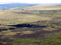
markj99 visited on 8th Jun 2023 - their rating: Cond: 3 Amb: 5 Access: 2 I parked up on the edge of Twelve Men's moor at SX 25841 75851, walked E to reach the valley between Kilmar Tor & Bearah Tor. I followed the valley W to reach the Bearah Tor Tramway, then headed S towards the obvious cairns on the summit of Langstone Downs. There are three contiguous stone cairns on a SE-NW Axis.
Bladup have visited here
")
You may be viewing yesterday's version of this page. To see the most up to date information please register for a free account.
")
")
")
")
")
")
")
")
")
")
")
")
")
Do not use the above information on other web sites or publications without permission of the contributor.
Click here to see more info for this site
Nearby sites
Key: Red: member's photo, Blue: 3rd party photo, Yellow: other image, Green: no photo - please go there and take one, Grey: site destroyed
Download sites to:
KML (Google Earth)
GPX (GPS waypoints)
CSV (Garmin/Navman)
CSV (Excel)
To unlock full downloads you need to sign up as a Contributory Member. Otherwise downloads are limited to 50 sites.
Turn off the page maps and other distractions
Nearby sites listing. In the following links * = Image available
199m W 268° Langstone Downs row Stone Row / Alignment (SX253737)
608m NNW 349° Bearah Tramway Cist* Cist (SX254743)
626m NNW 341° Bearah Tramway Cairn* Cairn (SX25327430)
677m W 264° Withey Brook* Cairn (SX2482273656)
820m N 8° Linkinhorne Reave Misc. Earthwork (SX2564274508)
1.0km NE 50° Bearah Common Long Cairn* Chambered Cairn (SX26327435)
1.1km NNW 343° Kilmar Tor* Rock Outcrop (SX252748)
1.2km NNW 338° High Rock propped stone* Natural Stone / Erratic / Other Natural Feature (SX2509074809)
1.2km NNW 344° Kilmar Tor propped stone* Natural Stone / Erratic / Other Natural Feature (SX2521374856)
1.3km SSE 165° Stowe's Pound* Ancient Village or Settlement (SX25787247)
1.3km SSE 166° The Cheesewring* Natural Stone / Erratic / Other Natural Feature (SX25787239)
1.3km NNW 341° Kilmar Tor North Propped Stone* Natural Stone / Erratic / Other Natural Feature (SX2510874982)
1.4km W 272° Siblyback Menhir* Standing Stone (Menhir) (SX241738)
1.5km WSW 244° Craddock Moor Prehistoric Settlement* Ancient Village or Settlement (SX24157310)
1.6km NNW 347° Pyramid Stone (Kilmar Tor)* Natural Stone / Erratic / Other Natural Feature (SX25187526)
1.6km N 358° Twelve Men's Moor Cairns Barrow Cemetery (SX255753)
1.6km NW 321° Trewortha Kerb cairn and cist* Chambered Cairn (SX24527499)
1.6km SSW 206° Craddock Moor Stone Setting* Standing Stones (SX24747227)
1.6km E 86° Notter Tor Ancient Village or Settlement (SX27157377)
1.8km SSW 193° Craddock Moor platform cairn* Cairn (SX25027196)
1.8km SSE 162° Rillaton N Cairn* Cairn (SX26007195)
1.9km NNW 346° Twelve men's moor cairn and cist* Cist (SX25117551)
1.9km S 170° The Hurlers Avenue* Multiple Stone Rows / Avenue (SX2576371864)
1.9km SSE 162° Rillaton Barrow* Round Barrow(s) (SX26027191)
1.9km NNW 333° Trewortha Cairns* Cairn (SX24697543)
View more nearby sites and additional images


 We would like to know more about this location. Please feel free to add a brief description and any relevant information in your own language.
 Wir möchten mehr über diese Stätte erfahren. Bitte zögern Sie nicht, eine kurze Beschreibung und relevante Informationen in Deutsch hinzuzufügen.
 Nous aimerions en savoir encore un peu sur les lieux. S'il vous plaît n'hesitez pas à ajouter une courte description et tous les renseignements pertinents dans votre propre langue.
 Quisieramos informarnos un poco más de las lugares. No dude en añadir una breve descripción y otros datos relevantes en su propio idioma.