<< Our Photo Pages >> Stowe's Pound - Ancient Village or Settlement in England in Cornwall
Submitted by Petercastle on Thursday, 14 September 2017 Page Views: 14739
Multi-periodSite Name: Stowe's Pound Alternative Name: Stowes PoundCountry: England County: Cornwall Type: Ancient Village or Settlement
Nearest Village: Minions
Map Ref: SX25787247 Landranger Map Number: 201
Latitude: 50.526008N Longitude: 4.459314W
Condition:
| 5 | Perfect |
| 4 | Almost Perfect |
| 3 | Reasonable but with some damage |
| 2 | Ruined but still recognisable as an ancient site |
| 1 | Pretty much destroyed, possibly visible as crop marks |
| 0 | No data. |
| -1 | Completely destroyed |
| 5 | Superb |
| 4 | Good |
| 3 | Ordinary |
| 2 | Not Good |
| 1 | Awful |
| 0 | No data. |
| 5 | Can be driven to, probably with disabled access |
| 4 | Short walk on a footpath |
| 3 | Requiring a bit more of a walk |
| 2 | A long walk |
| 1 | In the middle of nowhere, a nightmare to find |
| 0 | No data. |
| 5 | co-ordinates taken by GPS or official recorded co-ordinates |
| 4 | co-ordinates scaled from a detailed map |
| 3 | co-ordinates scaled from a bad map |
| 2 | co-ordinates of the nearest village |
| 1 | co-ordinates of the nearest town |
| 0 | no data |
Internal Links:
External Links:
I have visited· I would like to visit
ajmp3003 visited on 1st Jan 2024 - their rating: Cond: 3 Amb: 4 Access: 2
markj99 visited on 22nd Feb 2023 - their rating: Cond: 2 Amb: 4 Access: 3 I have visited Stowe's Pound on several occasions without exploring it fully. This time I made a clockwise circuit round the enclosure from the Cheesewring. The enclosure is dominated by the stone stacks on the summit of Stowe's Hill.
lucasn visited on 9th Jul 2019 - their rating: Cond: 4 Amb: 5 Access: 3
graemefield visited on 4th Apr 2018 - their rating: Cond: 3 Amb: 5 Access: 3
hevveh TheCaptain JimChampion cazzyjane have visited here
Average ratings for this site from all visit loggers: Condition: 3 Ambience: 4.5 Access: 2.75

The southern, upper enclosure contains an area of around 0.75ha with the flat- topped wall reaching 4.5m in height and 4m in width to the north. Where well preserved, the wall appears to be faced with orthostats separated by dry stone walling which may be a later addition (Fletcher 1989, 71-76).
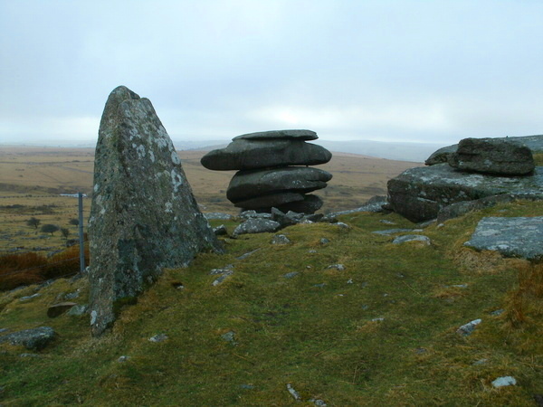
The upper enclosure contains a number of flat, turf covered areas but little sign of occupation. There are some hollow scrapes behind parts of the wall, possibly similar to those at Carn Brea (Fletcher 1989, 71-76). The wall itself links together a number of ‘cheese-ring’ type rock formations that surround the edges of the summit.
The lower enclosure has an area of around 5ha. The wall stands up to 1.5m tall and is made up of a rubble core faced with orthostats, earth fast boulders, and, again, some dry stone coursing. This wall may have up to 14 entrances. There are around 110 identified hut circles within this lower area, as well as 19 platforms cut into the ground (Fletcher 1989, 71-76).
To the southeast, just off the moor, is the Trethevy Quoit portal dolmen. Two further possible long barrows are within 3km of the site (Tilley 1995, 17).
Source: The Early Neolithic Tor Enclosures of Southwest Britain, Simon R. Davies
The University of Birmingham Ph.D Thesis (PDF)
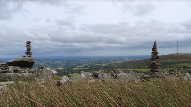
Note: Stones from Stowe's Pound on Bodmin Moor, Cornwall, are being used to build the "fairy stacks" by people "probably unaware" they are breaking the law. The stacks have been described as "historic vandalism". More details in the comments on our page
You may be viewing yesterday's version of this page. To see the most up to date information please register for a free account.


These are just the first 25 photos of Stowe's Pound. If you log in with a free user account you will be able to see our entire collection.
Do not use the above information on other web sites or publications without permission of the contributor.
Click here to see more info for this site
Nearby sites
Key: Red: member's photo, Blue: 3rd party photo, Yellow: other image, Green: no photo - please go there and take one, Grey: site destroyed
Download sites to:
KML (Google Earth)
GPX (GPS waypoints)
CSV (Garmin/Navman)
CSV (Excel)
To unlock full downloads you need to sign up as a Contributory Member. Otherwise downloads are limited to 50 sites.
Turn off the page maps and other distractions
Nearby sites listing. In the following links * = Image available
80m S 178° The Cheesewring* Natural Stone / Erratic / Other Natural Feature (SX25787239)
564m SSE 155° Rillaton N Cairn* Cairn (SX26007195)
606m S 180° The Hurlers Avenue* Multiple Stone Rows / Avenue (SX2576371864)
609m SSE 155° Rillaton Barrow* Round Barrow(s) (SX26027191)
707m SE 142° Minions Settlement* Ancient Village or Settlement (SX262719)
884m S 172° The Hurlers North* Stone Circle (SX25877159)
913m SW 234° Craddock Moor platform cairn* Cairn (SX25027196)
1.0km S 175° The Hurlers (N)* Stone Circle (SX25847145)
1.1km S 175° The Hurlers causeway* Ancient Trackway (SX25837142)
1.1km WSW 257° Craddock Moor Stone Setting* Standing Stones (SX24747227)
1.1km S 175° The Hurlers* Stone Circle (SX25837140)
1.1km S 176° The Hurlers (C)* Stone Circle (SX25827139)
1.1km SW 233° Craddock Moor circle* Stone Circle (SX24877183)
1.1km S 182° The Hurlers Pipers* Standing Stones (SX25717135)
1.1km S 177° The Hurlers (S)* Stone Circle (SX25817133)
1.3km NNW 345° Langstone downs Cairns* Cairn (SX255737)
1.3km NNW 337° Langstone Downs row Stone Row / Alignment (SX253737)
1.4km SSW 206° Minions Round Cairns* Round Cairn (SX25157126)
1.4km SSE 168° Minions Mound* Round Barrow(s) (SX26017112)
1.4km S 178° Minions Platform Round Barrow* Cairn (SX25787109)
1.5km WSW 253° Craddock Moor embanked avenue* Misc. Earthwork (SX24377208)
1.5km NW 319° Withey Brook* Cairn (SX2482273656)
1.5km SSW 199° Minions Kerbed Cairn Cairn (SX25247103)
1.6km SSW 203° Trewalla Farm Settlement* Ancient Village or Settlement (SX25117106)
1.6km SSW 202° Minions Bronze Age round cairn. Cairn (SX25157103)
View more nearby sites and additional images


 We would like to know more about this location. Please feel free to add a brief description and any relevant information in your own language.
 Wir möchten mehr über diese Stätte erfahren. Bitte zögern Sie nicht, eine kurze Beschreibung und relevante Informationen in Deutsch hinzuzufügen.
 Nous aimerions en savoir encore un peu sur les lieux. S'il vous plaît n'hesitez pas à ajouter une courte description et tous les renseignements pertinents dans votre propre langue.
 Quisieramos informarnos un poco más de las lugares. No dude en añadir una breve descripción y otros datos relevantes en su propio idioma.