

<< Our Photo Pages >> Rillaton Barrow - Round Barrow(s) in England in Cornwall
Submitted by theCaptain on Sunday, 07 November 2004 Page Views: 18194
Neolithic and Bronze AgeSite Name: Rillaton Barrow Alternative Name: Craddock Moor barrowCountry: England County: Cornwall Type: Round Barrow(s)
Nearest Town: Liskeard Nearest Village: Minions
Map Ref: SX26027191 Landranger Map Number: 201
Latitude: 50.521048N Longitude: 4.45567W
Condition:
| 5 | Perfect |
| 4 | Almost Perfect |
| 3 | Reasonable but with some damage |
| 2 | Ruined but still recognisable as an ancient site |
| 1 | Pretty much destroyed, possibly visible as crop marks |
| 0 | No data. |
| -1 | Completely destroyed |
| 5 | Superb |
| 4 | Good |
| 3 | Ordinary |
| 2 | Not Good |
| 1 | Awful |
| 0 | No data. |
| 5 | Can be driven to, probably with disabled access |
| 4 | Short walk on a footpath |
| 3 | Requiring a bit more of a walk |
| 2 | A long walk |
| 1 | In the middle of nowhere, a nightmare to find |
| 0 | No data. |
| 5 | co-ordinates taken by GPS or official recorded co-ordinates |
| 4 | co-ordinates scaled from a detailed map |
| 3 | co-ordinates scaled from a bad map |
| 2 | co-ordinates of the nearest village |
| 1 | co-ordinates of the nearest town |
| 0 | no data |
Internal Links:
External Links:
I have visited· I would like to visit
DrewParsons would like to visit
markj99 visited on 7th Jun 2023 - their rating: Cond: 3 Amb: 4 Access: 3 Rillaton Barrow can be reached by walking NNE from the N Hurlers Stone Circle for c. 500 yards. There is an impressive cist on the E Arc.
TheCaptain JimChampion AngieLake ocifant cazzyjane have visited here
")
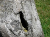
At first I couldn’t find the chamber from where the Rillaton Gold Cup was found, but after I walked all around the barrow, I realised that the chamber is halfway up the eastern side, in a separate depression of its own, so I suspect most people who pass this way do not realise it is there.
The cover slab is clearly seen sitting on the supporting side slabs, with a gap near one end through which the inside can be seen. The inside looks bigger than I remember, and it is very well lined with nicely smoothed and squared slabs. Some good stonework went into making this.
The top of the mound has been well dug into, and even after all the recent dry weather, there is a pond in it.
It makes me wonder whether there are any more chambers in the mound just waiting to be found, and if there is just the single chamber, why is it somehow randomly placed near but not at one of the edges?
English Heritage Scheduled Monument 15064.
You may be viewing yesterday's version of this page. To see the most up to date information please register for a free account.
")
")
")
")
")
")
")
")
")
")
")
")
")
")
")
")
")
")
")
")
")
")
")
")
These are just the first 25 photos of Rillaton Barrow. If you log in with a free user account you will be able to see our entire collection.
Do not use the above information on other web sites or publications without permission of the contributor.
Click here to see more info for this site
Nearby sites
Key: Red: member's photo, Blue: 3rd party photo, Yellow: other image, Green: no photo - please go there and take one, Grey: site destroyed
Download sites to:
KML (Google Earth)
GPX (GPS waypoints)
CSV (Garmin/Navman)
CSV (Excel)
To unlock full downloads you need to sign up as a Contributory Member. Otherwise downloads are limited to 50 sites.
![]()
Turn off the page maps and other distractions
Nearby sites listing. In the following links * = Image available
45m NNW 332° Rillaton N Cairn* Cairn (SX26007195)
180m E 91° Minions Settlement* Ancient Village or Settlement (SX262719)
260m WSW 258° The Hurlers Avenue* Multiple Stone Rows / Avenue (SX2576371864)
353m SSW 203° The Hurlers North* Stone Circle (SX25877159)
494m SSW 199° The Hurlers (N)* Stone Circle (SX25847145)
525m SSW 199° The Hurlers causeway* Ancient Trackway (SX25837142)
536m NNW 332° The Cheesewring* Natural Stone / Erratic / Other Natural Feature (SX25787239)
544m SSW 198° The Hurlers* Stone Circle (SX25837140)
557m SSW 199° The Hurlers (C)* Stone Circle (SX25827139)
609m NNW 335° Stowe's Pound* Ancient Village or Settlement (SX25787247)
616m SSW 198° The Hurlers (S)* Stone Circle (SX25817133)
639m SSW 207° The Hurlers Pipers* Standing Stones (SX25717135)
790m S 179° Minions Mound* Round Barrow(s) (SX26017112)
854m SSW 194° Minions Platform Round Barrow* Cairn (SX25787109)
998m W 271° Craddock Moor platform cairn* Cairn (SX25027196)
1.1km SW 231° Minions Round Cairns* Round Cairn (SX25157126)
1.1km W 264° Craddock Moor circle* Stone Circle (SX24877183)
1.2km SW 220° Minions Kerbed Cairn Cairn (SX25247103)
1.2km SW 223° Minions Bronze Age round cairn. Cairn (SX25157103)
1.2km SW 225° Trewalla Farm Settlement* Ancient Village or Settlement (SX25117106)
1.3km WNW 284° Craddock Moor Stone Setting* Standing Stones (SX24747227)
1.4km SSW 208° Minions Cairns Cairn (SX25357073)
1.4km SSW 197° The Long Stone (Minions)* Standing Stone (Menhir) (SX25547055)
1.7km W 274° Craddock Moor embanked avenue* Misc. Earthwork (SX24377208)
1.7km SE 134° Caradon Hill cairns* Barrow Cemetery (SX272707)
View more nearby sites and additional images


 We would like to know more about this location. Please feel free to add a brief description and any relevant information in your own language.
 Wir möchten mehr über diese Stätte erfahren. Bitte zögern Sie nicht, eine kurze Beschreibung und relevante Informationen in Deutsch hinzuzufügen.
 Nous aimerions en savoir encore un peu sur les lieux. S'il vous plaît n'hesitez pas à ajouter une courte description et tous les renseignements pertinents dans votre propre langue.
 Quisieramos informarnos un poco más de las lugares. No dude en añadir una breve descripción y otros datos relevantes en su propio idioma.