


<< Our Photo Pages >> Stoke Churchyard Cross - Ancient Cross in England in Devon
Submitted by dooclay on Friday, 21 July 2023 Page Views: 821
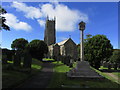
Early MedievalSite Name: Stoke Churchyard CrossCountry: England
NOTE: This site is 5.4 km away from the location you searched for.
County: Devon Type: Ancient Cross
Nearest Village: Stoke
Map Ref: SS235247
Latitude: 50.994559N Longitude: 4.516508W
Condition:
| 5 | Perfect |
| 4 | Almost Perfect |
| 3 | Reasonable but with some damage |
| 2 | Ruined but still recognisable as an ancient site |
| 1 | Pretty much destroyed, possibly visible as crop marks |
| 0 | No data. |
| -1 | Completely destroyed |
| 5 | Superb |
| 4 | Good |
| 3 | Ordinary |
| 2 | Not Good |
| 1 | Awful |
| 0 | No data. |
| 5 | Can be driven to, probably with disabled access |
| 4 | Short walk on a footpath |
| 3 | Requiring a bit more of a walk |
| 2 | A long walk |
| 1 | In the middle of nowhere, a nightmare to find |
| 0 | No data. |
| 5 | co-ordinates taken by GPS or official recorded co-ordinates |
| 4 | co-ordinates scaled from a detailed map |
| 3 | co-ordinates scaled from a bad map |
| 2 | co-ordinates of the nearest village |
| 1 | co-ordinates of the nearest town |
| 0 | no data |
Internal Links:
External Links:
")
Source Devon HER:
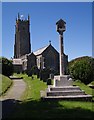
A cross stands in the churchyard, south-east of the church. It was restored in 1897, replacing the old churchyard cross, the socket stone being removed into the church. So its all modern??
You may be viewing yesterday's version of this page. To see the most up to date information please register for a free account.
Do not use the above information on other web sites or publications without permission of the contributor.
Nearby Images from Geograph Britain and Ireland:
©2007(licence)
©2019(licence)
©2015(licence)
©2019(licence)
©2013(licence)
The above images may not be of the site on this page, they are loaded from Geograph.
Please Submit an Image of this site or go out and take one for us!
Click here to see more info for this site
Nearby sites
Key: Red: member's photo, Blue: 3rd party photo, Yellow: other image, Green: no photo - please go there and take one, Grey: site destroyed
Download sites to:
KML (Google Earth)
GPX (GPS waypoints)
CSV (Garmin/Navman)
CSV (Excel)
To unlock full downloads you need to sign up as a Contributory Member. Otherwise downloads are limited to 50 sites.
Turn off the page maps and other distractions
Nearby sites listing. In the following links * = Image available
137m E 95° St Nectan's Well (Stoke)* Holy Well or Sacred Spring (SS2363624683)
1.6km ESE 119° St Leonard's Well (Hartland)* Holy Well or Sacred Spring (SS2486423870)
3.2km SE 131° St Clare's Well* Holy Well or Sacred Spring (SS2582422541)
5.1km SSE 148° Bursdon Moor Barrow Cemetery* Round Barrow(s) (SS2611220257)
5.4km ENE 68° Windbury Head Fort* Hillfort (SS28612658)
5.6km SSW 198° Embury Beacon Fort* Hillfort (SS216194)
6.4km S 184° St Nectan's Well (Welcombe)* Holy Well or Sacred Spring (SS22851838)
7.3km SE 134° Gorvin West Barrows* Round Barrow(s) (SS2859519471)
7.7km E 97° Clovelly Dykes* Hillfort (SS311235)
8.6km SSE 159° Woolley Long Barrow* Long Barrow (SS2627516605)
9.8km SSW 195° St John's Well (Morwenstow)* Holy Well or Sacred Spring (SS2064815298)
9.9km SSW 195° Morwenstow Churchyard Cross* Ancient Cross (SS20551527)
9.9km SSW 200° St Morwenna's Well* Holy Well or Sacred Spring (SS1980215483)
10.7km SSE 168° Wrasford Moor Barrow Cemetary* Barrow Cemetery (SS2529114170)
12.4km E 94° Buck's Mills Fort Promontory Fort / Cliff Castle (SS35892349)
12.6km SSE 163° Taylors Cross Tumuli* Round Barrow(s) (SS2669012535)
13.3km S 172° Ladywell (Kilkhampton) Holy Well or Sacred Spring (SS2485111487)
14.0km SE 138° St Peter's Well (Bradworthy)* Holy Well or Sacred Spring (SS325139)
14.2km S 174° Brentspool Barrows* Round Barrow(s) (SS24561057)
14.4km E 91° Peppercombe Castle Hillfort (SS379240)
16.5km ESE 114° Wrangworthy Cross* Barrow Cemetery (SS384174)
16.9km S 189° Northcott Mouth Tumuli* Barrow Cemetery (SS203081)
17.0km S 182° Earthquake Cist* Cist (SS22250773)
17.7km S 180° Stamford Hill settlement* Ancient Village or Settlement (SS22750705)
18.2km S 188° Summerleaze Barrows* Barrow Cemetery (SS2038106810)
View more nearby sites and additional images


 We would like to know more about this location. Please feel free to add a brief description and any relevant information in your own language.
 Wir möchten mehr über diese Stätte erfahren. Bitte zögern Sie nicht, eine kurze Beschreibung und relevante Informationen in Deutsch hinzuzufügen.
 Nous aimerions en savoir encore un peu sur les lieux. S'il vous plaît n'hesitez pas à ajouter une courte description et tous les renseignements pertinents dans votre propre langue.
 Quisieramos informarnos un poco más de las lugares. No dude en añadir una breve descripción y otros datos relevantes en su propio idioma.