


<< Our Photo Pages >> Warren's Barrow - Barrow Cemetery in England in Cornwall
Submitted by Bladup on Wednesday, 25 September 2013 Page Views: 4057
Neolithic and Bronze AgeSite Name: Warren's Barrow Alternative Name: Carland CrossCountry: England
NOTE: This site is 1.2 km away from the location you searched for.
County: Cornwall Type: Barrow Cemetery
Map Ref: SW846539
Latitude: 50.345527N Longitude: 5.028841W
Condition:
| 5 | Perfect |
| 4 | Almost Perfect |
| 3 | Reasonable but with some damage |
| 2 | Ruined but still recognisable as an ancient site |
| 1 | Pretty much destroyed, possibly visible as crop marks |
| 0 | No data. |
| -1 | Completely destroyed |
| 5 | Superb |
| 4 | Good |
| 3 | Ordinary |
| 2 | Not Good |
| 1 | Awful |
| 0 | No data. |
| 5 | Can be driven to, probably with disabled access |
| 4 | Short walk on a footpath |
| 3 | Requiring a bit more of a walk |
| 2 | A long walk |
| 1 | In the middle of nowhere, a nightmare to find |
| 0 | No data. |
| 5 | co-ordinates taken by GPS or official recorded co-ordinates |
| 4 | co-ordinates scaled from a detailed map |
| 3 | co-ordinates scaled from a bad map |
| 2 | co-ordinates of the nearest village |
| 1 | co-ordinates of the nearest town |
| 0 | no data |
Internal Links:
External Links:
")
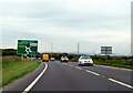
Warren's barrow is right by the A30, and is the biggest and also the most intact out of all the barrows in the Carland cross barrow cemetery, It's a big one at 3.6m in height and 36m in diameter, Pastscape describes it as being like a barrow built upon a barrow [Or I think maybe just maybe a Henge Bank].
You may be viewing yesterday's version of this page. To see the most up to date information please register for a free account.
")
")
")
")
Do not use the above information on other web sites or publications without permission of the contributor.
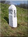
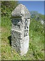
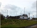
Nearby Images from Geograph Britain and Ireland:
©2021(licence)
©2017(licence)
©2020(licence)

©2017(licence)
©2013(licence)
The above images may not be of the site on this page, they are loaded from Geograph.
Please Submit an Image of this site or go out and take one for us!
Click here to see more info for this site
Nearby sites
Key: Red: member's photo, Blue: 3rd party photo, Yellow: other image, Green: no photo - please go there and take one, Grey: site destroyed
Download sites to:
KML (Google Earth)
GPX (GPS waypoints)
CSV (Garmin/Navman)
CSV (Excel)
To unlock full downloads you need to sign up as a Contributory Member. Otherwise downloads are limited to 50 sites.
Turn off the page maps and other distractions
Nearby sites listing. In the following links * = Image available
4.4km NNE 18° Dairyland Farm World* Modern Stone Circle etc (SW861580)
5.4km WNW 284° Twelve barrows* Barrow Cemetery (SW794554)
5.4km SSW 196° Bishops Wood Fort* Hillfort (SW82914873)
5.5km NE 54° St Enoder Cross* Ancient Cross (SW892569)
5.6km ESE 111° Fentonladock* Holy Well or Sacred Spring (SW8978851719)
6.1km WNW 303° Cubert Round* Ancient Village or Settlement (SW796574)
6.5km WSW 255° Caer Kief* Ancient Village or Settlement (SW782525)
6.7km W 273° Piran's Round* Ancient Village or Settlement (SW779545)
6.9km NNE 18° Our Lady of Nance* Holy Well or Sacred Spring (SW870604)
7.1km WSW 254° Caer Dane* Ancient Village or Settlement (SW777522)
7.1km SE 127° Ventonglidder Holy Well or Sacred Spring (SW9015149402)
7.1km WNW 301° Cubert.* Early Christian Sculptured Stone (SW786578)
7.4km NNW 329° Treringey Round* Ancient Village or Settlement (SW810604)
7.8km WNW 287° St Piran's Cross* Ancient Cross (SW7722156450)
8.0km N 358° Rialton Manor* Holy Well or Sacred Spring (SW847619)
8.0km S 183° Truro Eastern District Centre Neolithic Enclosure* Causewayed Enclosure (SW838459)
8.2km WNW 285° St. Piran's Lost Oratory* Early Christian Sculptured Stone (SW768564)
8.3km SSE 150° Trelowthas Cross* Ancient Cross (SW885466)
8.4km N 6° St. Pedyr's Well* Holy Well or Sacred Spring (SW8579462245)
8.5km SSW 196° Kenwyn* Holy Well or Sacred Spring (SW819458)
8.6km NW 308° Cubert Common Tumulus* Round Barrow(s) (SW78055943)
8.6km NW 316° Crantock* Holy Well or Sacred Spring (SW789604)
8.7km NNW 340° Barrowfields* Barrow Cemetery (SW819622)
8.7km NE 51° Indian Queens inscribed stone* Early Christian Sculptured Stone (SW91625912)
8.8km WNW 302° Trevornick Farm* Holy Well or Sacred Spring (SW7733958890)
View more nearby sites and additional images


 We would like to know more about this location. Please feel free to add a brief description and any relevant information in your own language.
 Wir möchten mehr über diese Stätte erfahren. Bitte zögern Sie nicht, eine kurze Beschreibung und relevante Informationen in Deutsch hinzuzufügen.
 Nous aimerions en savoir encore un peu sur les lieux. S'il vous plaît n'hesitez pas à ajouter une courte description et tous les renseignements pertinents dans votre propre langue.
 Quisieramos informarnos un poco más de las lugares. No dude en añadir una breve descripción y otros datos relevantes en su propio idioma.