 with our Megalithic Portal iPhone app")

<< Our Photo Pages >> Blakey Tor West - Cist in England in Devon
Submitted by Anne T on Tuesday, 18 October 2016 Page Views: 1527
Neolithic and Bronze AgeSite Name: Blakey Tor WestCountry: England County: Devon Type: Cist
Nearest Town: Princetown Nearest Village: Two Bridges
Map Ref: SX61247355
Latitude: 50.545206N Longitude: 3.959786W
Condition:
| 5 | Perfect |
| 4 | Almost Perfect |
| 3 | Reasonable but with some damage |
| 2 | Ruined but still recognisable as an ancient site |
| 1 | Pretty much destroyed, possibly visible as crop marks |
| 0 | No data. |
| -1 | Completely destroyed |
| 5 | Superb |
| 4 | Good |
| 3 | Ordinary |
| 2 | Not Good |
| 1 | Awful |
| 0 | No data. |
| 5 | Can be driven to, probably with disabled access |
| 4 | Short walk on a footpath |
| 3 | Requiring a bit more of a walk |
| 2 | A long walk |
| 1 | In the middle of nowhere, a nightmare to find |
| 0 | No data. |
| 5 | co-ordinates taken by GPS or official recorded co-ordinates |
| 4 | co-ordinates scaled from a detailed map |
| 3 | co-ordinates scaled from a bad map |
| 2 | co-ordinates of the nearest village |
| 1 | co-ordinates of the nearest town |
| 0 | no data |
Be the first person to rate this site - see the 'Contribute!' box in the right hand menu.
Internal Links:
External Links:
")
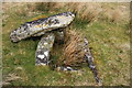
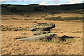
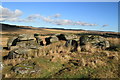
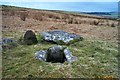
Information about Blakey Tor West cist comes from Prehistoric Dartmoor Walks. Their notes say: The incomplete cist is oriented NW-SE. It measures about 0.85m long, 0.4m to 0.55m wide and 0.25m deep internally. The upright W side slab is 0.9m by 0.2m by 0.25m and the surviving end slab is 0.4m by 0.2m by 0.25m. The E side is formed by a flat-sided boulder which is c. 1.1m long, at least 0.6m thick and 0.25m high. The SE side is open. The coverstone is 1.7m by 0.7m by 0.4m and leans against the W side of the cist."
Further information can be found on Pastscape, Monument Number 443262, which adds that the cist is an "open ended box ... lying within an irregularly shaped peaty mound ... possibly a peated up cairn." They record that the cairn "lies on a slight north west slope on a rounded high point to the south of Courton Tor at 372m OD and that it lies amidst a scattered spread of large natural earthfast boulders on a rather uneven peat layer covered by close cropped moorland pasture."
The Heritage Gateway for Devon & Dartmoor HER number MDV6244 tell us that this is one of two cairns with cist on Blakey Tor, south of Blackbrook River and north of Royal Hill. "This site is on the local list of Nationally Important Dartmoor Sites." They date the cairn and cist from the Early Neolithic to the Late Bronze Age (4000BC to 701BC). This site is scheduled.
You may be viewing yesterday's version of this page. To see the most up to date information please register for a free account.
Do not use the above information on other web sites or publications without permission of the contributor.
Nearby Images from Geograph Britain and Ireland:
©2009(licence)
©2010(licence)
©2010(licence)
©2006(licence)
©2013(licence)
The above images may not be of the site on this page, they are loaded from Geograph.
Please Submit an Image of this site or go out and take one for us!
Click here to see more info for this site
Nearby sites
Key: Red: member's photo, Blue: 3rd party photo, Yellow: other image, Green: no photo - please go there and take one, Grey: site destroyed
Download sites to:
KML (Google Earth)
GPX (GPS waypoints)
CSV (Garmin/Navman)
CSV (Excel)
To unlock full downloads you need to sign up as a Contributory Member. Otherwise downloads are limited to 50 sites.
Turn off the page maps and other distractions
Nearby sites listing. In the following links * = Image available
72m E 82° Moorlands Farm* Cairn (SX6131273558)
491m S 174° Crock of Gold* Cairn (SX61287306)
675m NNW 329° Roundhill South West 2* Cist (SX60917414)
688m NNW 331° Roundhill South West 1* Cairn (SX60927416)
762m S 174° Royal Hill Summit* Cairn (SX61307279)
782m WNW 292° Blackabrook* Cairn (SX60527386)
863m N 353° Roundhill East (Devon)* Cairn (SX61167441)
883m NNW 343° Two Bridges Stone Row / Alignment (SX610744)
883m NNW 343° Roundhill Alignment Stone Row / Alignment (SX610744)
900m NNW 346° Roundhill Summit* Cairn (SX61057443)
1.1km E 91° Moorlands Farm stone row Stone Row / Alignment (SX623735)
1.1km E 97° Tor Royal Newtake Stone Row / Alignment (SX623734)
1.4km SE 141° Royal Hill Cairns (SX621724)* Cairn (SX6210872434)
1.5km SE 144° Royal Hill Cairns (SX621723)* Cairn (SX6208272334)
1.5km SSE 149° Royal Hill Cairns* Cairn (SX620722)
1.7km SSE 151° Royal Hill Cairns (SX620721)* Cairn (SX6201872079)
1.7km SSE 159° Royal Hill Cairns (SX618719)* Cairn (SX6181271945)
2.0km NNW 334° Beardown Farm Cist (SX60407540)
2.1km NE 38° Muddy Lakes Newtake Cairn (SX62587518)
2.2km ESE 104° Swincombe cairn circle and cist* Cist (SX63327298)
2.2km SE 126° Tor Royal Cairn (SX62967224)
2.2km W 267° High Moorland Visitor Centre* Museum (SX59037348)
2.3km SE 126° Joan Ford Newtake W* Cairn (SX63047218)
2.3km SE 125° Joan Ford Newtake E* Cairn (SX63147216)
2.4km NW 312° Holming Beam Stone* Ancient Mine, Quarry or other Industry (SX5947975229)
View more nearby sites and additional images


 We would like to know more about this location. Please feel free to add a brief description and any relevant information in your own language.
 Wir möchten mehr über diese Stätte erfahren. Bitte zögern Sie nicht, eine kurze Beschreibung und relevante Informationen in Deutsch hinzuzufügen.
 Nous aimerions en savoir encore un peu sur les lieux. S'il vous plaît n'hesitez pas à ajouter une courte description et tous les renseignements pertinents dans votre propre langue.
 Quisieramos informarnos un poco más de las lugares. No dude en añadir una breve descripción y otros datos relevantes en su propio idioma.