


<< Our Photo Pages >> Royal Hill Cairns (SX621723) - Cairn in England in Devon
Submitted by thecaptain on Tuesday, 22 October 2013 Page Views: 2318
Neolithic and Bronze AgeSite Name: Royal Hill Cairns (SX621723) Alternative Name: Royal Hill E4; Grinsell Lydford 89; Turner E21; Royal Hill (N); Dixon 23; Butler (V4 65.5)Country: England County: Devon Type: Cairn
Nearest Town: Princetown Nearest Village: Princetown
Map Ref: SX6208272334
Latitude: 50.534476N Longitude: 3.947459W
Condition:
| 5 | Perfect |
| 4 | Almost Perfect |
| 3 | Reasonable but with some damage |
| 2 | Ruined but still recognisable as an ancient site |
| 1 | Pretty much destroyed, possibly visible as crop marks |
| 0 | No data. |
| -1 | Completely destroyed |
| 5 | Superb |
| 4 | Good |
| 3 | Ordinary |
| 2 | Not Good |
| 1 | Awful |
| 0 | No data. |
| 5 | Can be driven to, probably with disabled access |
| 4 | Short walk on a footpath |
| 3 | Requiring a bit more of a walk |
| 2 | A long walk |
| 1 | In the middle of nowhere, a nightmare to find |
| 0 | No data. |
| 5 | co-ordinates taken by GPS or official recorded co-ordinates |
| 4 | co-ordinates scaled from a detailed map |
| 3 | co-ordinates scaled from a bad map |
| 2 | co-ordinates of the nearest village |
| 1 | co-ordinates of the nearest town |
| 0 | no data |
Internal Links:
External Links:
I have visited· I would like to visit
graemefield would like to visit
TheCaptain has visited here
 (PID:113749)")
See our Royal Hill Cairns page for an overview of all sites.
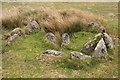
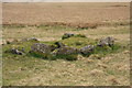
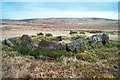
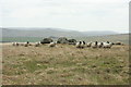
Update December 2019: This cist is featured on the Prehistoric Dartmoor Walks (PDW) website - see their entry for the Royal Hill, Central Platform Cairn Circle and Cist, which tells us: "The cairn has an overall diameter of about 7.5m in diameter, and 0.6m high, with a flattish top. There are traces of an inner kerb 4.5m in diameter, and an outer one 5.7m across comprising boulders and slabs, the largest 1.5m long, 0.6m high, and 0.2m thick. The interior of the central cist is about 0.8m square with four stones up to 0.25m thick and 0.6m deep but the southern one overlaps the sides, is 1m long, and gives the cist its NW to SE alignment. This and the two end stones incline inwards; the northern one inclines slightly outwards. There is no cover stone".
The cist is also recorded as Pastscape Monument No. 443331, and as MDV6304 (Cist on Royal Hill) on the Devon and Dartmoor HER.
You may be viewing yesterday's version of this page. To see the most up to date information please register for a free account.
 (PID:113748)")
 (PID:113747)")
 (PID:22817)")
 (PID:22816)")
Do not use the above information on other web sites or publications without permission of the contributor.
Nearby Images from Geograph Britain and Ireland:
©2009(licence)
©2009(licence)
©2014(licence)
©2005(licence)
©2009(licence)
The above images may not be of the site on this page, they are loaded from Geograph.
Please Submit an Image of this site or go out and take one for us!
Click here to see more info for this site
Nearby sites
Key: Red: member's photo, Blue: 3rd party photo, Yellow: other image, Green: no photo - please go there and take one, Grey: site destroyed
Download sites to:
KML (Google Earth)
GPX (GPS waypoints)
CSV (Garmin/Navman)
CSV (Excel)
To unlock full downloads you need to sign up as a Contributory Member. Otherwise downloads are limited to 50 sites.
Turn off the page maps and other distractions
Nearby sites listing. In the following links * = Image available
103m NNE 13° Royal Hill Cairns (SX621724)* Cairn (SX6210872434)
157m SSW 210° Royal Hill Cairns* Cairn (SX620722)
263m SSW 193° Royal Hill Cairns (SX620721)* Cairn (SX6201872079)
473m SSW 213° Royal Hill Cairns (SX618719)* Cairn (SX6181271945)
880m E 95° Tor Royal Cairn (SX62967224)
903m WNW 299° Royal Hill Summit* Cairn (SX61307279)
967m E 98° Joan Ford Newtake W* Cairn (SX63047218)
1.1km E 98° Joan Ford Newtake E* Cairn (SX63147216)
1.1km NW 311° Crock of Gold* Cairn (SX61287306)
1.1km N 10° Tor Royal Newtake Stone Row / Alignment (SX623734)
1.1km ESE 106° Joan Ford Newtake row* Multiple Stone Rows / Avenue (SX6318071989)
1.2km N 9° Moorlands Farm stone row Stone Row / Alignment (SX623735)
1.4km ENE 61° Swincombe cairn circle and cist* Cist (SX63327298)
1.4km SE 145° Fox Tor Newtake North* Cist (SX62867116)
1.4km NNW 326° Moorlands Farm* Cairn (SX6131273558)
1.5km NW 324° Blakey Tor West* Cist (SX61247355)
1.6km SSE 149° Fox Tor Newtake South* Cairn (SX62867097)
1.9km S 185° Goldsmith Cross E1 Cist (SX61877040)
2.0km S 186° Rha cairn circle and cist* Cist (SX6180470321)
2.0km ENE 64° Sherberton circle* Stone Circle (SX6394073173)
2.1km SSE 165° Childe’s Tomb* Cairn (SX62577030)
2.1km ENE 59° Sherberton Row* Stone Row / Alignment (SX63917336)
2.2km NW 326° Roundhill South West 2* Cist (SX60917414)
2.2km S 188° Goldsmith's Cross E3 Cist (SX6174170204)
2.2km NW 326° Roundhill South West 1* Cairn (SX60927416)
View more nearby sites and additional images


 We would like to know more about this location. Please feel free to add a brief description and any relevant information in your own language.
 Wir möchten mehr über diese Stätte erfahren. Bitte zögern Sie nicht, eine kurze Beschreibung und relevante Informationen in Deutsch hinzuzufügen.
 Nous aimerions en savoir encore un peu sur les lieux. S'il vous plaît n'hesitez pas à ajouter une courte description et tous les renseignements pertinents dans votre propre langue.
 Quisieramos informarnos un poco más de las lugares. No dude en añadir una breve descripción y otros datos relevantes en su propio idioma.