<< Our Photo Pages >> Caher Conor - Stone Fort or Dun in Ireland (Republic of) in Co. Kerry
Submitted by jeffrep on Sunday, 17 August 2008 Page Views: 8775
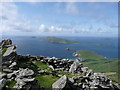
Multi-periodSite Name: Caher Conor Alternative Name: Cathair na gConchuireachCountry: Ireland (Republic of) County: Co. Kerry Type: Stone Fort or Dun
Nearest Town: Dingle Nearest Village: Ventry
Map Ref: V328976
Latitude: 52.105509N Longitude: 10.441112W
Condition:
| 5 | Perfect |
| 4 | Almost Perfect |
| 3 | Reasonable but with some damage |
| 2 | Ruined but still recognisable as an ancient site |
| 1 | Pretty much destroyed, possibly visible as crop marks |
| 0 | No data. |
| -1 | Completely destroyed |
| 5 | Superb |
| 4 | Good |
| 3 | Ordinary |
| 2 | Not Good |
| 1 | Awful |
| 0 | No data. |
| 5 | Can be driven to, probably with disabled access |
| 4 | Short walk on a footpath |
| 3 | Requiring a bit more of a walk |
| 2 | A long walk |
| 1 | In the middle of nowhere, a nightmare to find |
| 0 | No data. |
| 5 | co-ordinates taken by GPS or official recorded co-ordinates |
| 4 | co-ordinates scaled from a detailed map |
| 3 | co-ordinates scaled from a bad map |
| 2 | co-ordinates of the nearest village |
| 1 | co-ordinates of the nearest town |
| 0 | no data |
Internal Links:
External Links:
I have visited· I would like to visit
eirrac5 would like to visit
jeffrep visited on 24th Apr 2008 - their rating: Cond: 3 Amb: 5 Access: 4
")
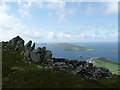
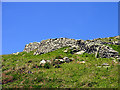
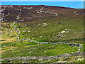
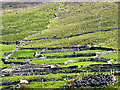
Also known as the Fahan Beehive Huts, Caher Conor (Cathair na gConchuireach) is located on the south side of Mount Eagle west of Dingle. The complex consists of five structures. The clochan (beehive huts) in Caher Conor were probably single family dwellings and were attached to each other with a doorway leading from one to the other. The hillside at one time had over 400 of these drystone, corbelled huts surviving, prompting one antiquarian in the 19th century to refer to the area as the "City of Fahan." As one observer states, "Dating the huts is difficult because the skill of corbelling has been used in Newgrange (3100 BCE) and as recently as the 1950s. The huts at Fahan along the Slea Head Drive may well date to the 12th Century CE when the incoming Normans forced the Irish off the good land and out to the periphery of the Dingle Peninsula."
You may be viewing yesterday's version of this page. To see the most up to date information please register for a free account.
")
")
")
")
Do not use the above information on other web sites or publications without permission of the contributor.
Nearby Images from Geograph Britain and Ireland:
©2010(licence)
©2005(licence)
©2005(licence)
©2005(licence)
©2010(licence)
The above images may not be of the site on this page, they are loaded from Geograph.
Please Submit an Image of this site or go out and take one for us!
Click here to see more info for this site
Nearby sites
Click here to view sites on an interactive map of the areaKey: Red: member's photo, Blue: 3rd party photo, Yellow: other image, Green: no photo - please go there and take one, Grey: site destroyed
Download sites to:
KML (Google Earth)
GPX (GPS waypoints)
CSV (Garmin/Navman)
CSV (Excel)
To unlock full downloads you need to sign up as a Contributory Member. Otherwise downloads are limited to 50 sites.
Turn off the page maps and other distractions
Nearby sites listing. In the following links * = Image available
2.2km E 96° Dunbeg* Stone Fort or Dun (V3502297293)
2.3km WNW 284° An Dún Mór Ogham stone* Early Christian Sculptured Stone
2.3km E 91° Fahan Standing Stones (V351975)
5.9km NNW 344° Clogher Stone Row / Alignment (Q314033)
6.2km NE 55° Giant's Table* Wedge Tomb (Q3801)
6.2km N 9° Teeravane Stone Circle (Q340037)
6.6km NNE 20° Altóir na Gréine* Wedge Tomb
7.1km NE 53° Kilcolman Cross-Inscribed Ogham Stone* Early Christian Sculptured Stone (Q386017)
7.4km NNE 23° Ballineanig-Castlequarter Standing Stones (Q359043)
8.0km NNE 27° Reask* Early Christian Sculptured Stone (Q367046)
8.4km NE 43° Leataoibh Meánach standing stone* Standing Stone (Menhir)
8.9km NNE 24° Baile an Reannaigh ogham stone* Ancient Village or Settlement
9.5km ENE 76° Colaiste Ide Ogham Stones* Museum (V4211599651)
9.7km NE 39° Gallarus Oratory* Ancient Temple (Q392049)
10.6km ENE 69° Milltown S Standing Stones (Q429010)
10.7km ENE 69° Gallán na Cille Brice standing stone* Standing Stone (Menhir)
10.7km ENE 69° Baile an Mhuilinn rock art* Rock Art
10.7km ENE 69° Milltown N* Standing Stones (Q42960113)
10.7km NE 40° Cathair Deargáin cashel* Stone Fort or Dun
11.0km ENE 57° Kilfountain Cross Slab* Early Christian Sculptured Stone (Q423032)
11.3km ENE 57° Kilfountan Standing Stone* Standing Stone (Menhir) (Q425035)
11.3km NE 39° Cill Maoilchéadair sundial* Early Christian Sculptured Stone
11.4km NE 39° Kilmalkedar Early Christian Sculptured Stone* Early Christian Sculptured Stone (Q40230622)
11.4km NE 39° Kilmalkedar Ogham Stone* Standing Stone (Menhir) (Q403062)
11.8km NE 53° Knockavrogeen E Standing Stones (Q42580434)
View more nearby sites and additional images


 We would like to know more about this location. Please feel free to add a brief description and any relevant information in your own language.
 Wir möchten mehr über diese Stätte erfahren. Bitte zögern Sie nicht, eine kurze Beschreibung und relevante Informationen in Deutsch hinzuzufügen.
 Nous aimerions en savoir encore un peu sur les lieux. S'il vous plaît n'hesitez pas à ajouter une courte description et tous les renseignements pertinents dans votre propre langue.
 Quisieramos informarnos un poco más de las lugares. No dude en añadir una breve descripción y otros datos relevantes en su propio idioma.