<< Our Photo Pages >> Loughash Wedge Tomb - Wedge Tomb in Ireland (Northern) in Co. Tyrone
Submitted by LizH on Sunday, 17 August 2008 Page Views: 7599
Neolithic and Bronze AgeSite Name: Loughash Wedge TombCountry: Ireland (Northern) County: Co. Tyrone Type: Wedge Tomb
Nearest Town: Strabane Nearest Village: Dunnamanagh
Map Ref: C484008
Latitude: 54.852623N Longitude: 7.24721W
Condition:
| 5 | Perfect |
| 4 | Almost Perfect |
| 3 | Reasonable but with some damage |
| 2 | Ruined but still recognisable as an ancient site |
| 1 | Pretty much destroyed, possibly visible as crop marks |
| 0 | No data. |
| -1 | Completely destroyed |
| 5 | Superb |
| 4 | Good |
| 3 | Ordinary |
| 2 | Not Good |
| 1 | Awful |
| 0 | No data. |
| 5 | Can be driven to, probably with disabled access |
| 4 | Short walk on a footpath |
| 3 | Requiring a bit more of a walk |
| 2 | A long walk |
| 1 | In the middle of nowhere, a nightmare to find |
| 0 | No data. |
| 5 | co-ordinates taken by GPS or official recorded co-ordinates |
| 4 | co-ordinates scaled from a detailed map |
| 3 | co-ordinates scaled from a bad map |
| 2 | co-ordinates of the nearest village |
| 1 | co-ordinates of the nearest town |
| 0 | no data |
Internal Links:
External Links:
I have visited· I would like to visit
lizh has visited here
")
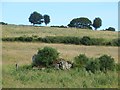
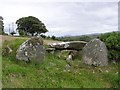
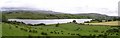
This is a reasonably well preserved Wedge tomb, with one capstone and a double portal.
It faces west. During excavations, an apparently cremated bone and some other artefacts were found.
It is set in a field and there is public access.
You may be viewing yesterday's version of this page. To see the most up to date information please register for a free account.
")
Do not use the above information on other web sites or publications without permission of the contributor.
coldrum has found this location on Google Street View:
Nearby Images from Geograph Britain and Ireland:
©2014(licence)
©2006(licence)
©2006(licence)
©2014(licence)
©2006(licence)
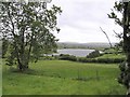
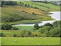
The above images may not be of the site on this page, they are loaded from Geograph.
Please Submit an Image of this site or go out and take one for us!
Click here to see more info for this site
Nearby sites
Click here to view sites on an interactive map of the areaKey: Red: member's photo, Blue: 3rd party photo, Yellow: other image, Green: no photo - please go there and take one, Grey: site destroyed
Download sites to:
KML (Google Earth)
GPX (GPS waypoints)
CSV (Garmin/Navman)
CSV (Excel)
To unlock full downloads you need to sign up as a Contributory Member. Otherwise downloads are limited to 50 sites.
Turn off the page maps and other distractions
Nearby sites listing. In the following links * = Image available
2.8km WSW 259° Lisnaragh Irish rath* Stone Fort or Dun (C45690023)
3.2km E 82° Cashelbane* Wedge Tomb (C5162001300)
3.3km E 86° Altaghoney* Stone Circle (C5173001070)
3.6km SSW 211° Banagher* Stone Circle (H466977)
4.0km SSE 169° Doorat SE, SW Stone Circle (H49249688)
4.0km SSE 169° Doorat NW, W Stone Circle (H49249688)
4.0km SSE 169° Doorat NW, E Stone Circle (H49249688)
4.1km SSE 168° Doorat SE, NE Stone Circle (H493968)
4.1km SW 220° Meendamph B* Stone Circle (H458976)
4.3km SSE 166° Doorat SE Stone Row / Alignment (H495966)
4.5km SSW 213° Meendamph A Stone Circle (H460970)
5.9km SSW 201° Balix standing stone* Standing Stone (Menhir) (H46369523)
6.0km S 173° Butterlope Northern Stone Circle* Stone Circle (H49209484)
6.0km S 173° Butterlope standing stone* Standing Stone (Menhir) (H49259481)
6.2km S 172° Butterlope Southern Stone Circle Stone Circle (H493947)
6.2km S 172° Clogherny Butterlope W Stone Circle (H493947)
6.2km S 177° Balix Lower* Court Tomb (H488946)
6.3km N 355° Lackagh* Stone Circle (C4778007050)
6.3km S 177° Clogherny Meenerrigal* Stone Circle (H488945)
6.4km SSE 152° Mullaghcarbatagh cairn 2* Cairn (H51499519)
6.6km S 171° Glenga stone circle* Stone Circle (H49509430)
6.9km SSE 152° Mullaghcarbatagh cairn 3* Cairn (H51739476)
6.9km SSE 151° Mullaghcarbatagh cairn 1* Cairn (H51809477)
7.6km WSW 256° Knocknahorna Multiple Stone Rows / Avenue (H410989)
7.6km WSW 256° Knocknahorna Stone Circle (H410989)
View more nearby sites and additional images


 We would like to know more about this location. Please feel free to add a brief description and any relevant information in your own language.
 Wir möchten mehr über diese Stätte erfahren. Bitte zögern Sie nicht, eine kurze Beschreibung und relevante Informationen in Deutsch hinzuzufügen.
 Nous aimerions en savoir encore un peu sur les lieux. S'il vous plaît n'hesitez pas à ajouter une courte description et tous les renseignements pertinents dans votre propre langue.
 Quisieramos informarnos un poco más de las lugares. No dude en añadir una breve descripción y otros datos relevantes en su propio idioma.