<< Our Photo Pages >> Balix Lower - Court Tomb in Ireland (Northern) in Co. Tyrone
Submitted by Anthony_Weir on Sunday, 13 October 2002 Page Views:
Neolithic and Bronze AgeSite Name: Balix LowerCountry: Ireland (Northern) County: Co. Tyrone Type: Court Tomb
Nearest Village: Plumbridge
Map Ref: H488946
Discoverer Map Number: D13
Latitude: 54.796896N Longitude: 7.242027W
Condition:
| 5 | Perfect |
| 4 | Almost Perfect |
| 3 | Reasonable but with some damage |
| 2 | Ruined but still recognisable as an ancient site |
| 1 | Pretty much destroyed, possibly visible as crop marks |
| 0 | No data. |
| -1 | Completely destroyed |
| 5 | Superb |
| 4 | Good |
| 3 | Ordinary |
| 2 | Not Good |
| 1 | Awful |
| 0 | No data. |
| 5 | Can be driven to, probably with disabled access |
| 4 | Short walk on a footpath |
| 3 | Requiring a bit more of a walk |
| 2 | A long walk |
| 1 | In the middle of nowhere, a nightmare to find |
| 0 | No data. |
| 5 | co-ordinates taken by GPS or official recorded co-ordinates |
| 4 | co-ordinates scaled from a detailed map |
| 3 | co-ordinates scaled from a bad map |
| 2 | co-ordinates of the nearest village |
| 1 | co-ordinates of the nearest town |
| 0 | no data |
Internal Links:
External Links:
")
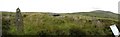
The N arm of the forecourt leads to an entrance-sill, and the S arm leads to the middle of the S entry-jamb.
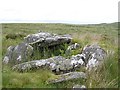
~ 1.7km SSE is Clogherny wedge-tomb and stone circle (H 488945) –monuments best looked for on a good day. The wedge-tomb, set in a round cairn, has a straight façade and one surviving roofstone. The gallery is segmented by jamb-stones and both ends are closed by door-slabs. Surrounding it is a circle of 17 low stones about 90 cms high, wityh a diameter of 18 metres. The whole monument is an interesting fusion of court-tomb, wedge-tomb and stone circle.
Circles of small stones are common in this area, often with alignments or stone-rows and sometimes with cairns.
You may be viewing yesterday's version of this page. To see the most up to date information please register for a free account.
")
")
Do not use the above information on other web sites or publications without permission of the contributor.
Nearby Images from Geograph Britain and Ireland:
©2006(licence)
©2006(licence)
©2006(licence)
©2007(licence)
©2006(licence)
The above images may not be of the site on this page, they are loaded from Geograph.
Please Submit an Image of this site or go out and take one for us!
Click here to see more info for this site
Nearby sites
Click here to view sites on an interactive map of the areaKey: Red: member's photo, Blue: 3rd party photo, Yellow: other image, Green: no photo - please go there and take one, Grey: site destroyed
Download sites to:
KML (Google Earth)
GPX (GPS waypoints)
CSV (Garmin/Navman)
CSV (Excel)
To unlock full downloads you need to sign up as a Contributory Member. Otherwise downloads are limited to 50 sites.
Turn off the page maps and other distractions
Nearby sites listing. In the following links * = Image available
100m S 181° Clogherny Meenerrigal* Stone Circle (H488945)
465m ENE 60° Butterlope Northern Stone Circle* Stone Circle (H49209484)
495m ENE 66° Butterlope standing stone* Standing Stone (Menhir) (H49259481)
508m E 79° Clogherny Butterlope W Stone Circle (H493947)
508m E 79° Butterlope Southern Stone Circle Stone Circle (H493947)
759m ESE 114° Glenga stone circle* Stone Circle (H49509430)
2.1km SSE 159° Aghalane bronze age complex cairn NE* Cairn (H49569266)
2.1km SSE 161° Aghalane bronze age complex standing stone NE* Standing Stone (Menhir) (H49529262)
2.1km SSE 162° Aghalane bronze age complex standing stone N* Standing Stone (Menhir) (H49489260)
2.1km SSE 153° Aghalane standing stone* Standing Stone (Menhir) (H4977092720)
2.1km SSE 162° Aghalane stone circle* Stone Circle (H49479259)
2.1km NNE 20° Doorat SE Stone Row / Alignment (H495966)
2.1km SSE 163° Aghalane bronze age complex cist W* Cist (H49469258)
2.1km SSE 162° Aghalane bronze age complex cist E* Cist (H49479258)
2.2km SSE 163° Aghalane bronze age complex stone row and circle S* Stone Circle (H49469247)
2.3km NNE 13° Doorat SE, NE Stone Circle (H493968)
2.3km SSE 165° Aghalane bronze age complex standing stone pair* Standing Stones (H49429241)
2.3km NNE 12° Doorat NW, E Stone Circle (H49249688)
2.3km NNE 12° Doorat NW, W Stone Circle (H49249688)
2.3km NNE 12° Doorat SE, SW Stone Circle (H49249688)
2.5km WNW 285° Balix standing stone* Standing Stone (Menhir) (H46369523)
2.6km SE 126° Bradkeel cashel* Stone Fort or Dun (H50939310)
2.6km SE 127° Bradkeel standing stone* Standing Stone (Menhir) (H50959304)
2.7km SSE 166° Aghalane stone row Stone Row / Alignment (H495920)
2.7km ENE 78° Mullaghcarbatagh cairn 2* Cairn (H51499519)
View more nearby sites and additional images


 We would like to know more about this location. Please feel free to add a brief description and any relevant information in your own language.
 Wir möchten mehr über diese Stätte erfahren. Bitte zögern Sie nicht, eine kurze Beschreibung und relevante Informationen in Deutsch hinzuzufügen.
 Nous aimerions en savoir encore un peu sur les lieux. S'il vous plaît n'hesitez pas à ajouter une courte description et tous les renseignements pertinents dans votre propre langue.
 Quisieramos informarnos un poco más de las lugares. No dude en añadir una breve descripción y otros datos relevantes en su propio idioma.