<< Our Photo Pages >> Mullaghcarbatagh cairn 2 - Cairn in Ireland (Northern) in Co. Tyrone
Submitted by JAGamble on Wednesday, 26 July 2023 Page Views: 131
Neolithic and Bronze AgeSite Name: Mullaghcarbatagh cairn 2Country: Ireland (Northern) County: Co. Tyrone Type: Cairn
Nearest Town: Strabane Nearest Village: Plumbridge
Map Ref: H51499519
Latitude: 54.801927N Longitude: 7.200104W
Condition:
| 5 | Perfect |
| 4 | Almost Perfect |
| 3 | Reasonable but with some damage |
| 2 | Ruined but still recognisable as an ancient site |
| 1 | Pretty much destroyed, possibly visible as crop marks |
| 0 | No data. |
| -1 | Completely destroyed |
| 5 | Superb |
| 4 | Good |
| 3 | Ordinary |
| 2 | Not Good |
| 1 | Awful |
| 0 | No data. |
| 5 | Can be driven to, probably with disabled access |
| 4 | Short walk on a footpath |
| 3 | Requiring a bit more of a walk |
| 2 | A long walk |
| 1 | In the middle of nowhere, a nightmare to find |
| 0 | No data. |
| 5 | co-ordinates taken by GPS or official recorded co-ordinates |
| 4 | co-ordinates scaled from a detailed map |
| 3 | co-ordinates scaled from a bad map |
| 2 | co-ordinates of the nearest village |
| 1 | co-ordinates of the nearest town |
| 0 | no data |
Internal Links:
External Links:
")
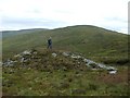
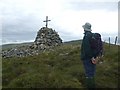
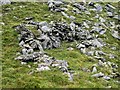
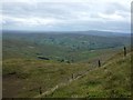
This is the most North Westerly of three cairns found around the summit of Mullaghcarbatagh mountain. This cairn is similar in size to cairn 1 at the summit, 500 metres to the South East. Unfortunately, this cairn has suffered damage in recent times and isn’t as well preserved as its neighbour on the summit. Some of the stone has been rearranged to form a pile that supports a wooden cross. The base of the cairn remains untouched as a wide, low mound 12 metres in diameter. Currently, the cairn’s height is 1.5 metres, but this would probably have been different prior to the moving of its stone. There are great views to the North and the West from the monument.
You may be viewing yesterday's version of this page. To see the most up to date information please register for a free account.
")
Do not use the above information on other web sites or publications without permission of the contributor.
Nearby Images from Geograph Britain and Ireland:
©2008(licence)
©2008(licence)
©2008(licence)
©2008(licence)
©2008(licence)
The above images may not be of the site on this page, they are loaded from Geograph.
Please Submit an Image of this site or go out and take one for us!
Click here to see more info for this site
Nearby sites
Click here to view sites on an interactive map of the areaKey: Red: member's photo, Blue: 3rd party photo, Yellow: other image, Green: no photo - please go there and take one, Grey: site destroyed
Download sites to:
KML (Google Earth)
GPX (GPS waypoints)
CSV (Garmin/Navman)
CSV (Excel)
To unlock full downloads you need to sign up as a Contributory Member. Otherwise downloads are limited to 50 sites.
Turn off the page maps and other distractions
Nearby sites listing. In the following links * = Image available
492m SSE 152° Mullaghcarbatagh cairn 3* Cairn (H51739476)
521m SE 144° Mullaghcarbatagh cairn 1* Cairn (H51809477)
2.2km SSW 196° Bradkeel cashel* Stone Fort or Dun (H50939310)
2.2km WSW 247° Glenga stone circle* Stone Circle (H49509430)
2.2km SSW 195° Bradkeel standing stone* Standing Stone (Menhir) (H50959304)
2.2km WSW 258° Butterlope Southern Stone Circle Stone Circle (H493947)
2.2km WSW 258° Clogherny Butterlope W Stone Circle (H493947)
2.3km W 261° Butterlope standing stone* Standing Stone (Menhir) (H49259481)
2.3km W 262° Butterlope Northern Stone Circle* Stone Circle (H49209484)
2.4km NW 306° Doorat SE Stone Row / Alignment (H495966)
2.7km NW 307° Doorat SE, NE Stone Circle (H493968)
2.7km WSW 258° Balix Lower* Court Tomb (H488946)
2.8km WSW 256° Clogherny Meenerrigal* Stone Circle (H488945)
2.8km SSE 166° Castledamph Multiple Stone Rows / Avenue (H522925)
2.8km SSE 166° Castledamph SE Stone Circle (H522925)
2.8km NW 308° Doorat NW, E Stone Circle (H49249688)
2.8km NW 308° Doorat NW, W Stone Circle (H49249688)
2.8km NW 308° Doorat SE, SW Stone Circle (H49249688)
2.9km SSE 166° Castledamph S Stone Circle (H522924)
3.0km SSE 167° Castledamph Stone Circle (H522923)
3.0km SW 215° Aghalane standing stone* Standing Stone (Menhir) (H4977092720)
3.2km SW 218° Aghalane bronze age complex cairn NE* Cairn (H49569266)
3.2km SW 218° Aghalane bronze age complex standing stone NE* Standing Stone (Menhir) (H49529262)
3.3km SW 218° Aghalane bronze age complex standing stone N* Standing Stone (Menhir) (H49489260)
3.3km SW 218° Aghalane stone circle* Stone Circle (H49479259)
View more nearby sites and additional images


 We would like to know more about this location. Please feel free to add a brief description and any relevant information in your own language.
 Wir möchten mehr über diese Stätte erfahren. Bitte zögern Sie nicht, eine kurze Beschreibung und relevante Informationen in Deutsch hinzuzufügen.
 Nous aimerions en savoir encore un peu sur les lieux. S'il vous plaît n'hesitez pas à ajouter une courte description et tous les renseignements pertinents dans votre propre langue.
 Quisieramos informarnos un poco más de las lugares. No dude en añadir una breve descripción y otros datos relevantes en su propio idioma.