


<< Our Photo Pages >> Clogherny Meenerrigal - Stone Circle in Ireland (Northern) in Co. Tyrone
Submitted by LizH on Sunday, 13 October 2002 Page Views: 8295
Neolithic and Bronze AgeSite Name: Clogherny Meenerrigal Alternative Name: Clogherny MeenerrigalCountry: Ireland (Northern) County: Co. Tyrone Type: Stone Circle
Map Ref: H488945
Discoverer Map Number: D13
Latitude: 54.795998N Longitude: 7.242044W
Condition:
| 5 | Perfect |
| 4 | Almost Perfect |
| 3 | Reasonable but with some damage |
| 2 | Ruined but still recognisable as an ancient site |
| 1 | Pretty much destroyed, possibly visible as crop marks |
| 0 | No data. |
| -1 | Completely destroyed |
| 5 | Superb |
| 4 | Good |
| 3 | Ordinary |
| 2 | Not Good |
| 1 | Awful |
| 0 | No data. |
| 5 | Can be driven to, probably with disabled access |
| 4 | Short walk on a footpath |
| 3 | Requiring a bit more of a walk |
| 2 | A long walk |
| 1 | In the middle of nowhere, a nightmare to find |
| 0 | No data. |
| 5 | co-ordinates taken by GPS or official recorded co-ordinates |
| 4 | co-ordinates scaled from a detailed map |
| 3 | co-ordinates scaled from a bad map |
| 2 | co-ordinates of the nearest village |
| 1 | co-ordinates of the nearest town |
| 0 | no data |
Internal Links:
External Links:
I have visited· I would like to visit
lizh has visited here
")
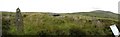
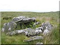
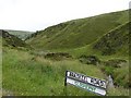
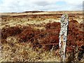
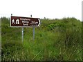
wedge tomb at the center of a stone circle. This site is a wedge tomb surrounded by a stone circle, and is in state care (though not very accessible - see below!). The stone circle is very fine, of stones of considerable height for Northern Ireland, and the tomb is also clearly recognisable. The stone circle is about 60 ft in diameter and has 17 stones, well spaced. It has been excavated, and apparently material from a pyre was found (burnt hazel, bone, flint and an arrowhead). Originally, also, it was found that cobbling was between the tomb and the circle. There is a 'tourist' brown sign on the road towards this site; mentioning the wedge tomb. It says it's 700 yds. Someone, presumably the farmer, has written on it, 'wear good boots and follow the posts'. I disagree. Wear very, very good boots and take a compass, map and be careful. The route is reasonably marked, but the posts have fallen over in places, rotted in the peat, and so you can't always see where the next one is. It obviously is visited, but not very frequently, so the route is not very clear at all. As well as long grass etc. and soft and very peaty surfaces, there are peat holes as well on the route. Nevertheless, despite coming the worse for a peat hole I think it was worth it!
You may be viewing yesterday's version of this page. To see the most up to date information please register for a free account.
")
")
")
")
Do not use the above information on other web sites or publications without permission of the contributor.
Nearby Images from Geograph Britain and Ireland:
©2006(licence)
©2006(licence)
©2006(licence)
©2013(licence)
©2006(licence)
The above images may not be of the site on this page, they are loaded from Geograph.
Please Submit an Image of this site or go out and take one for us!
Click here to see more info for this site
Nearby sites
Click here to view sites on an interactive map of the areaKey: Red: member's photo, Blue: 3rd party photo, Yellow: other image, Green: no photo - please go there and take one, Grey: site destroyed
Download sites to:
KML (Google Earth)
GPX (GPS waypoints)
CSV (Garmin/Navman)
CSV (Excel)
To unlock full downloads you need to sign up as a Contributory Member. Otherwise downloads are limited to 50 sites.
Turn off the page maps and other distractions
Nearby sites listing. In the following links * = Image available
100m N 1° Balix Lower* Court Tomb (H488946)
524m NE 50° Butterlope Northern Stone Circle* Stone Circle (H49209484)
537m ENE 69° Clogherny Butterlope W Stone Circle (H493947)
537m ENE 69° Butterlope Southern Stone Circle Stone Circle (H493947)
545m NE 56° Butterlope standing stone* Standing Stone (Menhir) (H49259481)
726m ESE 107° Glenga stone circle* Stone Circle (H49509430)
2.0km SSE 158° Aghalane bronze age complex cairn NE* Cairn (H49569266)
2.0km SSE 160° Aghalane bronze age complex standing stone NE* Standing Stone (Menhir) (H49529262)
2.0km SSE 161° Aghalane bronze age complex standing stone N* Standing Stone (Menhir) (H49489260)
2.0km SSE 161° Aghalane stone circle* Stone Circle (H49479259)
2.0km SSE 152° Aghalane standing stone* Standing Stone (Menhir) (H4977092720)
2.0km SSE 162° Aghalane bronze age complex cist W* Cist (H49469258)
2.0km SSE 161° Aghalane bronze age complex cist E* Cist (H49479258)
2.1km SSE 163° Aghalane bronze age complex stone row and circle S* Stone Circle (H49469247)
2.2km SSE 164° Aghalane bronze age complex standing stone pair* Standing Stones (H49429241)
2.2km NNE 19° Doorat SE Stone Row / Alignment (H495966)
2.4km NNE 13° Doorat SE, NE Stone Circle (H493968)
2.4km N 11° Doorat NW, E Stone Circle (H49249688)
2.4km N 11° Doorat NW, W Stone Circle (H49249688)
2.4km N 11° Doorat SE, SW Stone Circle (H49249688)
2.5km WNW 287° Balix standing stone* Standing Stone (Menhir) (H46369523)
2.5km SE 124° Bradkeel cashel* Stone Fort or Dun (H50939310)
2.6km SE 125° Bradkeel standing stone* Standing Stone (Menhir) (H50959304)
2.6km SSE 165° Aghalane stone row Stone Row / Alignment (H495920)
2.8km ENE 76° Mullaghcarbatagh cairn 2* Cairn (H51499519)
View more nearby sites and additional images


 We would like to know more about this location. Please feel free to add a brief description and any relevant information in your own language.
 Wir möchten mehr über diese Stätte erfahren. Bitte zögern Sie nicht, eine kurze Beschreibung und relevante Informationen in Deutsch hinzuzufügen.
 Nous aimerions en savoir encore un peu sur les lieux. S'il vous plaît n'hesitez pas à ajouter une courte description et tous les renseignements pertinents dans votre propre langue.
 Quisieramos informarnos un poco más de las lugares. No dude en añadir una breve descripción y otros datos relevantes en su propio idioma.