


<< Our Photo Pages >> Pund's Water - Chambered Cairn in Scotland in Shetland
Submitted by PAB on Thursday, 15 February 2001 Page Views: 12752
Neolithic and Bronze AgeSite Name: Pund's Water Alternative Name: Pundswater Neolithic Tomb and HouseCountry: Scotland County: Shetland Type: Chambered Cairn
Map Ref: HU32457124 Landranger Map Number: 3
Latitude: 60.423705N Longitude: 1.412509W
Condition:
| 5 | Perfect |
| 4 | Almost Perfect |
| 3 | Reasonable but with some damage |
| 2 | Ruined but still recognisable as an ancient site |
| 1 | Pretty much destroyed, possibly visible as crop marks |
| 0 | No data. |
| -1 | Completely destroyed |
| 5 | Superb |
| 4 | Good |
| 3 | Ordinary |
| 2 | Not Good |
| 1 | Awful |
| 0 | No data. |
| 5 | Can be driven to, probably with disabled access |
| 4 | Short walk on a footpath |
| 3 | Requiring a bit more of a walk |
| 2 | A long walk |
| 1 | In the middle of nowhere, a nightmare to find |
| 0 | No data. |
| 5 | co-ordinates taken by GPS or official recorded co-ordinates |
| 4 | co-ordinates scaled from a detailed map |
| 3 | co-ordinates scaled from a bad map |
| 2 | co-ordinates of the nearest village |
| 1 | co-ordinates of the nearest town |
| 0 | no data |
Internal Links:
External Links:
I have visited· I would like to visit
SolarMegalith would like to visit
PAB has visited here
")
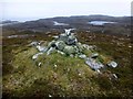
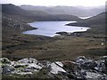
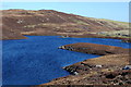
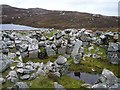
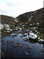
Pund's Water is reported to be the site of the best surviving 'heel-shaped' cairn on Mainland Shetland. The cairn stands on a plateau above the south shore of the loch known as Punds Water, and it is possible to obtain an almost aerial-view perspective from a nearby hilltop from which the 'heel-like' shape is much more easily recognized. From the same vantage point (HU 32653 71169), a further site can also be seen above the opposite bank, thought by some writers to be a contemporary homestead.
As with other sites visited in Shetland, the description given in Peter Guy's guide (Walking the coastline of Shetland, No. 4: Northmavine, ISBN:1904746179) was too succinct to need changing: "On a plateau above the south shore (of Punds Water loch) a mound of stones will be seen which closer inspection will reveal to be the best heel-shaped cairn on Mainland Shetland. It is estimated to have a 50ft façade, the outer ends of which are prolonged into horns. At the centre of the façade a roofless entrance leads to a roofless, trefoil shaped cairn chamber 6ft square. Build of white granite boulders, measuring 2ft x 1ft, it rises some 5ft above the surface of the knoll on which it stands. The walls of the chamber, which still stand 4ft 9ins high, are built in regular courses of masonry without any use of upright slabs. …. The roof of the cairn has collapsed inwards."
There are section and plan drawings of the cairn on the website of RCAHMS (Royal Commission on the Ancient & Historical Monuments of Scotland), together with sources of reference
You may be viewing yesterday's version of this page. To see the most up to date information please register for a free account.
")
")
")
")
Do not use the above information on other web sites or publications without permission of the contributor.
Nearby Images from Geograph Britain and Ireland:
©2013(licence)
©2007(licence)
©2011(licence)
©2005(licence)
©2011(licence)
The above images may not be of the site on this page, they are loaded from Geograph.
Please Submit an Image of this site or go out and take one for us!
Click here to see more info for this site
Nearby sites
Key: Red: member's photo, Blue: 3rd party photo, Yellow: other image, Green: no photo - please go there and take one, Grey: site destroyed
Download sites to:
KML (Google Earth)
GPX (GPS waypoints)
CSV (Garmin/Navman)
CSV (Excel)
To unlock full downloads you need to sign up as a Contributory Member. Otherwise downloads are limited to 50 sites.
![]()
Turn off the page maps and other distractions
Nearby sites listing. In the following links * = Image available
3.0km SSE 161° Islesburgh* Chambered Cairn (HU33456845)
4.5km SSE 148° Busta Brae* Standing Stones (HU34886739)
7.6km NNW 335° Gateside Chambered Cairn* Chambered Cairn (HU29137811)
8.4km NNW 329° Burnside Burnt Mound* Artificial Mound (HU28057842)
10.5km ENE 66° Crooksetter Hill - two Chambered Cairns* Chambered Cairn (HU420756)
10.7km SSW 196° Vementry* Chambered Cairn (HU296609)
12.3km NW 319° Giant's Stones Row (Shetland)* Multiple Stone Rows / Avenue (HU243805)
12.3km NW 319° Giant's Stones (Shetland)* Standing Stones (HU2431280555)
12.7km NW 318° Hamnavoe Broch* Broch or Nuraghe (HU2389380641)
12.9km WNW 302° Loch of Breckon Burnt Mound* Artificial Mound (HU21437803)
13.2km WNW 301° Sae Breck* Broch or Nuraghe (HU21057803)
13.6km NW 306° Loch of Houlland* Broch or Nuraghe (HU2140079160)
13.6km SSE 166° East Burra Firth Broch* Broch or Nuraghe (HU358580)
14.1km SSE 164° East Burra Firth Chambered Cairn* Chambered Cairn (HU364577)
14.6km SSW 197° Brindister Voe Broch* Broch or Nuraghe (HU284572)
14.7km NNE 15° Beorgs of Housetter* Standing Stones (HU36178546)
14.7km NNE 15° Trowie Knowe* Chambered Cairn (HU36208552)
14.9km ESE 115° Lunnasting Standing Stone* Standing Stone (Menhir) (HU4665)
15.4km S 180° Gravlaba* Standing Stones (HU325558)
15.5km SSW 206° Giant's Stone (West Burrafirth)* Standing Stone (Menhir) (HU2583157157)
15.6km SSW 206° West Burrafirth broch* Broch or Nuraghe (HU256572)
16.2km E 98° Chapel Knowe Broch or Nuraghe (HU48556910)
16.8km SW 220° Ness of Garth* Promontory Fort / Cliff Castle (HU216583)
16.9km SW 220° Bay of Garth Broch or Nuraghe (HU216582)
17.0km SW 217° Broch of Brousta Broch or Nuraghe (HU223575)
View more nearby sites and additional images


 We would like to know more about this location. Please feel free to add a brief description and any relevant information in your own language.
 Wir möchten mehr über diese Stätte erfahren. Bitte zögern Sie nicht, eine kurze Beschreibung und relevante Informationen in Deutsch hinzuzufügen.
 Nous aimerions en savoir encore un peu sur les lieux. S'il vous plaît n'hesitez pas à ajouter une courte description et tous les renseignements pertinents dans votre propre langue.
 Quisieramos informarnos un poco más de las lugares. No dude en añadir una breve descripción y otros datos relevantes en su propio idioma.