<< Other Photo Pages >> Vementry - Chambered Cairn in Scotland in Shetland
Submitted by Andy B on Monday, 17 February 2014 Page Views: 4221
Neolithic and Bronze AgeSite Name: VementryCountry: Scotland County: Shetland Type: Chambered Cairn
Map Ref: HU296609
Latitude: 60.331090N Longitude: 1.465785W
Condition:
| 5 | Perfect |
| 4 | Almost Perfect |
| 3 | Reasonable but with some damage |
| 2 | Ruined but still recognisable as an ancient site |
| 1 | Pretty much destroyed, possibly visible as crop marks |
| 0 | No data. |
| -1 | Completely destroyed |
| 5 | Superb |
| 4 | Good |
| 3 | Ordinary |
| 2 | Not Good |
| 1 | Awful |
| 0 | No data. |
| 5 | Can be driven to, probably with disabled access |
| 4 | Short walk on a footpath |
| 3 | Requiring a bit more of a walk |
| 2 | A long walk |
| 1 | In the middle of nowhere, a nightmare to find |
| 0 | No data. |
| 5 | co-ordinates taken by GPS or official recorded co-ordinates |
| 4 | co-ordinates scaled from a detailed map |
| 3 | co-ordinates scaled from a bad map |
| 2 | co-ordinates of the nearest village |
| 1 | co-ordinates of the nearest town |
| 0 | no data |
Internal Links:
External Links:
")
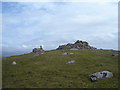
Vementry is an uninhabited island in Shetland, on the north side of the West Mainland, lying south of Muckle Roe. The island is known for its well-preserved chambered cairn, and two First World War gun emplacements. The chambered cairn is a well-preserved Neolithic heel-shaped cairn about 10 metres (33 ft) in diameter and rising to over 1.5 metres (4 ft 11 in) in height.
The heel-shaped cairn, with its usually cruciform chamber, is a type of megalithic monument that is found in Scotland, especially in Caithness and Sutherland and on the Shetland Islands. On Orkney, the Isbister Cairn is the only site that is similar in shape. The cruciform chambers, accessed via a short passage, have a large recess at the head and two smaller recesses to the side.
Source: Wikipedia
You may be viewing yesterday's version of this page. To see the most up to date information please register for a free account.
")
Do not use the above information on other web sites or publications without permission of the contributor.
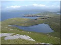
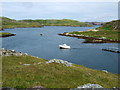
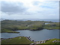
Nearby Images from Geograph Britain and Ireland:

©2008(licence)
©2008(licence)
©2008(licence)
©2011(licence)
©2008(licence)
The above images may not be of the site on this page, they are loaded from Geograph.
Please Submit an Image of this site or go out and take one for us!
Click here to see more info for this site
Nearby sites
Key: Red: member's photo, Blue: 3rd party photo, Yellow: other image, Green: no photo - please go there and take one, Grey: site destroyed
Download sites to:
KML (Google Earth)
GPX (GPS waypoints)
CSV (Garmin/Navman)
CSV (Excel)
To unlock full downloads you need to sign up as a Contributory Member. Otherwise downloads are limited to 50 sites.
Turn off the page maps and other distractions
Nearby sites listing. In the following links * = Image available
3.9km SSW 198° Brindister Voe Broch* Broch or Nuraghe (HU284572)
5.3km SW 226° Giant's Stone (West Burrafirth)* Standing Stone (Menhir) (HU2583157157)
5.4km SW 228° West Burrafirth broch* Broch or Nuraghe (HU256572)
5.9km SSE 151° Gravlaba* Standing Stones (HU325558)
6.8km ESE 116° East Burra Firth Broch* Broch or Nuraghe (HU358580)
7.5km ESE 116° East Burra Firth Chambered Cairn* Chambered Cairn (HU364577)
8.0km WSW 245° Broch of Brousta Broch or Nuraghe (HU223575)
8.3km NE 40° Busta Brae* Standing Stones (HU34886739)
8.4km WSW 252° Ness of Garth* Promontory Fort / Cliff Castle (HU216583)
8.4km WSW 252° Bay of Garth Broch or Nuraghe (HU216582)
8.5km NNE 27° Islesburgh* Chambered Cairn (HU33456845)
8.6km WSW 247° Rinns of Shurdimires* Stone Row / Alignment (HU2171057489)
9.3km SW 222° Burga Water Dun* Stone Fort or Dun (HU234539)
9.5km SW 225° Burga Water cairn* Cairn (HU22975407)
9.9km SSW 212° Trolligarts 1* Chambered Cairn (HU24415243)
9.9km SSW 213° Trolligarts 2* Chambered Cairn (HU24275249)
10.1km SSW 204° Scord of Brouster* Ancient Village or Settlement (HU25605165)
10.2km SSW 212° Loch Of Flatpunds* Chambered Cairn (HU24305219)
10.5km SSW 208° Cattapund Knowe cairn* Cairn (HU2480851533)
10.5km WSW 258° Holm of Melby NE Chambered Cairn (HU19315856)
10.6km WSW 257° Holm of Melby South Cairn (HU19225851)
10.6km WSW 258° Holm of Melby NW Cairn (HU19195856)
10.7km S 186° Stanydale* Stone Circle (HU2853450242)
10.7km NNE 16° Pund's Water* Chambered Cairn (HU32457124)
10.7km SSW 209° Hansies Crooie* Chambered Cairn (HU24485147)
View more nearby sites and additional images


 We would like to know more about this location. Please feel free to add a brief description and any relevant information in your own language.
 Wir möchten mehr über diese Stätte erfahren. Bitte zögern Sie nicht, eine kurze Beschreibung und relevante Informationen in Deutsch hinzuzufügen.
 Nous aimerions en savoir encore un peu sur les lieux. S'il vous plaît n'hesitez pas à ajouter une courte description et tous les renseignements pertinents dans votre propre langue.
 Quisieramos informarnos un poco más de las lugares. No dude en añadir una breve descripción y otros datos relevantes en su propio idioma.