

<< Our Photo Pages >> Modoc Rock Shelter - Cave or Rock Shelter in United States in Great Lakes Midwest
Submitted by bat400 on Tuesday, 16 October 2007 Page Views: 6723
Natural PlacesSite Name: Modoc Rock Shelter Alternative Name: 11RA501Country: United States Region: Great Lakes Midwest Type: Cave or Rock Shelter
Nearest Village: Modoc, IL
Latitude: 38.062470N Longitude: 90.0637W
Condition:
| 5 | Perfect |
| 4 | Almost Perfect |
| 3 | Reasonable but with some damage |
| 2 | Ruined but still recognisable as an ancient site |
| 1 | Pretty much destroyed, possibly visible as crop marks |
| 0 | No data. |
| -1 | Completely destroyed |
| 5 | Superb |
| 4 | Good |
| 3 | Ordinary |
| 2 | Not Good |
| 1 | Awful |
| 0 | No data. |
| 5 | Can be driven to, probably with disabled access |
| 4 | Short walk on a footpath |
| 3 | Requiring a bit more of a walk |
| 2 | A long walk |
| 1 | In the middle of nowhere, a nightmare to find |
| 0 | No data. |
| 5 | co-ordinates taken by GPS or official recorded co-ordinates |
| 4 | co-ordinates scaled from a detailed map |
| 3 | co-ordinates scaled from a bad map |
| 2 | co-ordinates of the nearest village |
| 1 | co-ordinates of the nearest town |
| 0 | no data |
Internal Links:
External Links:
I have visited· I would like to visit
bat400 has visited here
")
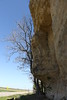
Shallow caves and shelters are seen all along limestone bluffs that rise up to 80 feet above the Mississippi floodplain in Randolf County, Illinois. One of these shelters near Modoc Illinois has been periodically used by humans for the last 9000 years.
The rock face above the shelter shows the smoke stains of fires in the last century, but digs carried out by the University of Wisconsin confirmed that the stone tools periodically found there are part of a history stretching back to hunters after the last Ice Age. Successive flooding of the Mississippi continued to bury levels of animal bones and stone tools until levees were built on the Mississippi to protect a wide flood plain. Over 25 feet of sediments were examined.
Carbon dating of bone and carbonized plant from hearths confirmed the age of the site use. There are several published articles on the food remains (small mammals and shellfish abound) and what it says about the people using the site.
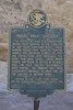
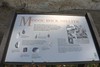
You can carefully park on the edge of the Illinois State Road 7 (Bluff Road) to view the rock face and read interpretive markers describing the finds. The actual alcove were excavation took place was only a few feet high in the post levee time period and even this has been partially filled in with topped with soil to protect the site for possible future examination. Similar shelters (and much larger ones) can be seen along the road. Many of them are used by modern locals to store equipment and provide protection for their homes and outbuildings - some of which are built with the bluff forming the back wall. Modoc Rock Shelter is a National Register of Historic Places site.
You may be viewing yesterday's version of this page. To see the most up to date information please register for a free account.
Do not use the above information on other web sites or publications without permission of the contributor.
bat400 has found this location on Google Street View:
Nearby Images from Flickr


The above images may not be of the site on this page, but were taken nearby. They are loaded from Flickr so please click on them for image credits.
Click here to see more info for this site
Nearby sites
Click here to view sites on an interactive map of the areaKey: Red: member's photo, Blue: 3rd party photo, Yellow: other image, Green: no photo - please go there and take one, Grey: site destroyed
Download sites to:
KML (Google Earth)
GPX (GPS waypoints)
CSV (Garmin/Navman)
CSV (Excel)
To unlock full downloads you need to sign up as a Contributory Member. Otherwise downloads are limited to 50 sites.
Turn off the page maps and other distractions
Nearby sites listing. In the following links * = Image available
12.9km SSE 161° Common Fields* Artificial Mound
45.0km NW 322° Mastodon State Historic Site* Museum
54.3km W 272° Washington State Park Petroglyphs* Rock Art
55.6km ESE 123° Cleiman Mound and Village Site* Artificial Mound
58.8km NNW 346° Sugarloaf Mound, Missouri* Artificial Mound
64.7km N 0° Cahokia - Mound 66 Artificial Mound
64.8km N 356° Sam Chucalo Mound* Artificial Mound
64.9km N 353° East Saint Louis Mound Center* Ancient Village or Settlement
65.4km N 351° Big Mound (St Louis)* Artificial Mound
65.5km N 0° Cahokia - Mound 72* Artificial Mound
65.8km N 0° Cahokia - Mound 60* Artificial Mound
65.8km N 360° Cahokia - Mound 59* Artificial Mound
65.9km N 0° Cahokia - Museum* Museum
66.0km N 0° Cahokia - Mound 55* Artificial Mound
66.0km N 358° Fingerhut tract* Ancient Village or Settlement
66.2km N 360° Cahokia - Mound 48 Artificial Mound
66.3km N 0° Cahokia* Ancient Village or Settlement
66.4km N 1° Cahokia - Mounds 30 and 31 Artificial Mound
66.4km N 360° Cahokia - Mound 42* Artificial Mound
66.4km N 359° Cahokia - Woodhenge* Timber Circle
66.4km N 359° Cahokia - Mound 44* Artificial Mound
66.5km N 0° Cahokia - Monk's Mound* Pyramid / Mastaba
66.5km N 0° Cahokia - Mound 36 Artificial Mound
66.6km N 1° Cahokia - Ramey Group* Ancient Village or Settlement
66.6km N 0° Cahokia - Stockade* Misc. Earthwork
View more nearby sites and additional images


 We would like to know more about this location. Please feel free to add a brief description and any relevant information in your own language.
 Wir möchten mehr über diese Stätte erfahren. Bitte zögern Sie nicht, eine kurze Beschreibung und relevante Informationen in Deutsch hinzuzufügen.
 Nous aimerions en savoir encore un peu sur les lieux. S'il vous plaît n'hesitez pas à ajouter une courte description et tous les renseignements pertinents dans votre propre langue.
 Quisieramos informarnos un poco más de las lugares. No dude en añadir una breve descripción y otros datos relevantes en su propio idioma.