<< Our Photo Pages >> Woolacombe Memorial - Modern Stone Circle etc in England in Devon
Submitted by theCaptain on Sunday, 04 January 2015 Page Views: 4896
Modern SitesSite Name: Woolacombe MemorialCountry: England
NOTE: This site is 0.262 km away from the location you searched for.
County: Devon Type: Modern Stone Circle etc
Nearest Town: Ilfracombe Nearest Village: Woolacombe
Map Ref: SS45494389
Latitude: 51.173318N Longitude: 4.211628W
Condition:
| 5 | Perfect |
| 4 | Almost Perfect |
| 3 | Reasonable but with some damage |
| 2 | Ruined but still recognisable as an ancient site |
| 1 | Pretty much destroyed, possibly visible as crop marks |
| 0 | No data. |
| -1 | Completely destroyed |
| 5 | Superb |
| 4 | Good |
| 3 | Ordinary |
| 2 | Not Good |
| 1 | Awful |
| 0 | No data. |
| 5 | Can be driven to, probably with disabled access |
| 4 | Short walk on a footpath |
| 3 | Requiring a bit more of a walk |
| 2 | A long walk |
| 1 | In the middle of nowhere, a nightmare to find |
| 0 | No data. |
| 5 | co-ordinates taken by GPS or official recorded co-ordinates |
| 4 | co-ordinates scaled from a detailed map |
| 3 | co-ordinates scaled from a bad map |
| 2 | co-ordinates of the nearest village |
| 1 | co-ordinates of the nearest town |
| 0 | no data |
Internal Links:
External Links:
I have visited· I would like to visit
TheCaptain has visited here
")
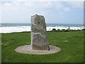
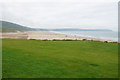
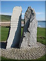
Spending a wet New Years afternoon exploring the top left corner of Devon, I stopped at Woolacombe to watch the surf for a while, and saw what looked like a standing stone on the grassy area above the northern edge of the beach.
Closer inspection reveals this to be two nice granite stones, tastefully made into a memorial to the American soldiers of the second World War who were based in this area in the build up to D-Day, using the beaches of Woolacombe and nearby Saunton to practise their invasion techniques.
You may be viewing yesterday's version of this page. To see the most up to date information please register for a free account.
")
")
")
Do not use the above information on other web sites or publications without permission of the contributor.
Nearby Images from Geograph Britain and Ireland:
©2009(licence)
©2009(licence)
©2017(licence)
©2009(licence)
©2009(licence)
The above images may not be of the site on this page, they are loaded from Geograph.
Please Submit an Image of this site or go out and take one for us!
Click here to see more info for this site
Nearby sites
Key: Red: member's photo, Blue: 3rd party photo, Yellow: other image, Green: no photo - please go there and take one, Grey: site destroyed
Download sites to:
KML (Google Earth)
GPX (GPS waypoints)
CSV (Garmin/Navman)
CSV (Excel)
To unlock full downloads you need to sign up as a Contributory Member. Otherwise downloads are limited to 50 sites.
Turn off the page maps and other distractions
Nearby sites listing. In the following links * = Image available
872m NE 53° The Konk Stone* Standing Stones (SS462444)
1.0km NE 56° Greystone* Standing Stone (Menhir) (SS46354443)
1.7km NNE 13° North Morte Well* Holy Well or Sacred Spring (SS459455)
2.7km NNE 33° Damage Barton* Standing Stones (SS47044615)
2.9km NNE 31° Damage Barton 2* Standing Stone (Menhir) (SS47064633)
3.1km NNE 32° Damage Barton 3* Standing Stone (Menhir) (SS47194647)
4.6km ENE 59° Whitestone (Lee)* Standing Stone (Menhir) (SS49564613)
5.0km S 191° St Helen's Well (Croyde)* Holy Well or Sacred Spring (SS4440538970)
6.5km SSE 148° Knowle Castle* Hillfort (SS488383)
7.2km SSE 152° St. Brannoc's Holy Well (Braunton)* Holy Well or Sacred Spring (SS487374)
8.6km ENE 62° Hillsborough* Hillfort (SS532477)
8.9km E 96° Centery Farm Tumuli* Barrow Cemetery (SS543427)
11.4km E 90° Berry Down Barrow Cemetery (SS569436)
11.6km SSE 160° Yelland* Multiple Stone Rows / Avenue (SS4912532889)
12.1km ENE 73° Newberry Camp Hillfort (SS57164708)
13.4km E 88° Mattocks Down Barrow* Long Barrow (SS589439)
13.6km ENE 71° Little Hangman Hill Misc. Earthwork (SS585480)
13.8km SE 133° Pilton Long Stone* Standing Stone (Menhir) (SS55313421)
14.0km SE 132° Ladywell (Pilton)* Holy Well or Sacred Spring (SS556342)
14.3km SE 126° Burridge Camp Ancient Village or Settlement (SS569352)
14.4km SE 139° Dripping Well (Barnstaple)* Holy Well or Sacred Spring (SS546327)
14.5km E 88° Mattocks Down Stone Row Stone Row / Alignment (SS6004643921)
14.5km E 88° Mattocks Down Stone* Standing Stone (Menhir) (SS60084388)
14.7km E 88° Mattocks Down circle Stone Circle (SS602439)
14.7km S 188° Shell Middens at Westward Ho!* Ancient Village or Settlement (SS429294)
View more nearby sites and additional images


 We would like to know more about this location. Please feel free to add a brief description and any relevant information in your own language.
 Wir möchten mehr über diese Stätte erfahren. Bitte zögern Sie nicht, eine kurze Beschreibung und relevante Informationen in Deutsch hinzuzufügen.
 Nous aimerions en savoir encore un peu sur les lieux. S'il vous plaît n'hesitez pas à ajouter une courte description et tous les renseignements pertinents dans votre propre langue.
 Quisieramos informarnos un poco más de las lugares. No dude en añadir una breve descripción y otros datos relevantes en su propio idioma.