<< Our Photo Pages >> Ceunant Coch Round Cairn 2 - Round Cairn in Wales in Gwynedd
Submitted by TAlanJones on Friday, 10 February 2023 Page Views: 366
Neolithic and Bronze AgeSite Name: Ceunant Coch Round Cairn 2 Alternative Name: Afon Gam Round Cairn 6Country: Wales
NOTE: This site is 3.578 km away from the location you searched for.
County: Gwynedd Type: Round Cairn
Nearest Town: Trawsfynydd Nearest Village: Bronaber
Map Ref: SH6856427259
Latitude: 52.826782N Longitude: 3.952193W
Condition:
| 5 | Perfect |
| 4 | Almost Perfect |
| 3 | Reasonable but with some damage |
| 2 | Ruined but still recognisable as an ancient site |
| 1 | Pretty much destroyed, possibly visible as crop marks |
| 0 | No data. |
| -1 | Completely destroyed |
| 5 | Superb |
| 4 | Good |
| 3 | Ordinary |
| 2 | Not Good |
| 1 | Awful |
| 0 | No data. |
| 5 | Can be driven to, probably with disabled access |
| 4 | Short walk on a footpath |
| 3 | Requiring a bit more of a walk |
| 2 | A long walk |
| 1 | In the middle of nowhere, a nightmare to find |
| 0 | No data. |
| 5 | co-ordinates taken by GPS or official recorded co-ordinates |
| 4 | co-ordinates scaled from a detailed map |
| 3 | co-ordinates scaled from a bad map |
| 2 | co-ordinates of the nearest village |
| 1 | co-ordinates of the nearest town |
| 0 | no data |
Internal Links:
External Links:
")
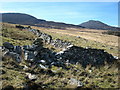
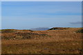
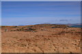
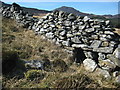
Situated on gradual easterly sloping terrain the cairn lies on fairly level ground. A second cairn lies a few hundred metres away to the north and an ancient settlement site lies between them. This is an area currently undergoing a period of re-wilding that has created a more challenging environment.
This is a large cairn with a 10m diameter. It is raised to about 0.40m at its highest point. The outer edges are turf covered with an interior ring consisting of scree stones of various sizes apparent. The centre has been disturbed and it is grassed over. Caflein have recorded the site as NPRN 543121.
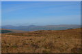
The cairn's location provides excellent views across the valley, the Afon Gam and the surrounding mountains.
You may be viewing yesterday's version of this page. To see the most up to date information please register for a free account.
")
")
")
Do not use the above information on other web sites or publications without permission of the contributor.
Nearby Images from Geograph Britain and Ireland:
©2007(licence)
©2014(licence)
©2014(licence)
©2014(licence)
©2007(licence)
The above images may not be of the site on this page, they are loaded from Geograph.
Please Submit an Image of this site or go out and take one for us!
Click here to see more info for this site
Nearby sites
Key: Red: member's photo, Blue: 3rd party photo, Yellow: other image, Green: no photo - please go there and take one, Grey: site destroyed
Download sites to:
KML (Google Earth)
GPX (GPS waypoints)
CSV (Garmin/Navman)
CSV (Excel)
To unlock full downloads you need to sign up as a Contributory Member. Otherwise downloads are limited to 50 sites.
Turn off the page maps and other distractions
Nearby sites listing. In the following links * = Image available
248m N 354° Ceunant Coch Round Cairn 1* Round Cairn (SH6854627507)
266m N 355° Ceunant Coch Stones* Natural Stone / Erratic / Other Natural Feature (SH6854627525)
495m NE 50° Afon Gam Rock Art* Rock Art (SH6895027570)
646m NE 50° Ffridd Bryn Coch Round Cairn 1* Round Cairn (SH6907327659)
647m NE 50° Ffridd Bryn Coch Recumbent Stones* Stone Row / Alignment (SH6907327660)
720m NNE 26° Afon Gam Round Cairn 4* Round Cairn (SH6889427900)
730m NNE 31° Afon Gam Round Cairn 3* Round Cairn (SH6895827875)
774m NE 38° Afon Gam Round Cairn 2* Round Cairn (SH6906127854)
858m NE 41° Afon Gam Round Cairn 1* Round Cairn (SH6915127887)
913m E 81° Craig Aberserw Round Cairn* Round Cairn (SH6947227381)
1.1km NE 39° Afon Gam Cairn Field* Barrow Cemetery (SH6928228109)
1.4km NE 43° Ffridd Bryn Coch Round Cairn 2* Round Cairn (SH6950928231)
1.4km NE 44° Ffridd Bryn Coch Cairn Field* Barrow Cemetery (SH6952728214)
1.5km NE 42° Ffridd Bryn Coch Stone Row* Stone Row / Alignment (SH6956628311)
1.5km NE 39° Ffridd Bryn Coch Standing Stone* Standing Stone (Menhir) (SH6955028406)
2.6km NNE 31° Crawcwellt Hut Circle South 2* Ancient Village or Settlement (SH6999129462)
2.7km NNE 31° Hut Circle Settlement at Crawcwellt South* Ancient Village or Settlement (SH7000029500)
2.7km NNE 30° Crawcwellt Hut Circle South 1* Ancient Village or Settlement (SH6995529534)
3.2km N 6° Crawcwellt Ancient Settlement* Ancient Village or Settlement (SH6899430425)
3.3km WNW 300° Rhinog Fawr Cairns* Cairn (SH6570929018)
3.4km NNE 13° Crawcwellt Cairn 6* Cairn (SH6939830535)
3.5km N 359° Crawcwellt Hut Circle Settlement North* Ancient Village or Settlement (SH686308)
3.6km N 1° Crawcwellt Ring Cairn* Ring Cairn (SH6869330816)
3.6km N 0° Crawcwellt Cairn 1* Cairn (SH6866430825)
3.6km NNE 17° Crawcwellt Iron Age Settlement South East* Ancient Village or Settlement (SH69703065)
View more nearby sites and additional images


 We would like to know more about this location. Please feel free to add a brief description and any relevant information in your own language.
 Wir möchten mehr über diese Stätte erfahren. Bitte zögern Sie nicht, eine kurze Beschreibung und relevante Informationen in Deutsch hinzuzufügen.
 Nous aimerions en savoir encore un peu sur les lieux. S'il vous plaît n'hesitez pas à ajouter une courte description et tous les renseignements pertinents dans votre propre langue.
 Quisieramos informarnos un poco más de las lugares. No dude en añadir una breve descripción y otros datos relevantes en su propio idioma.