


<< Our Photo Pages >> Ffridd Bryn Coch Standing Stone - Standing Stone (Menhir) in Wales in Gwynedd
Submitted by TAlanJones on Monday, 06 February 2023 Page Views: 243
Neolithic and Bronze AgeSite Name: Ffridd Bryn Coch Standing StoneCountry: Wales County: Gwynedd Type: Standing Stone (Menhir)
Nearest Town: Trawsfynydd Nearest Village: Bronaber
Map Ref: SH6955028406
Latitude: 52.837327N Longitude: 3.938027W
Condition:
| 5 | Perfect |
| 4 | Almost Perfect |
| 3 | Reasonable but with some damage |
| 2 | Ruined but still recognisable as an ancient site |
| 1 | Pretty much destroyed, possibly visible as crop marks |
| 0 | No data. |
| -1 | Completely destroyed |
| 5 | Superb |
| 4 | Good |
| 3 | Ordinary |
| 2 | Not Good |
| 1 | Awful |
| 0 | No data. |
| 5 | Can be driven to, probably with disabled access |
| 4 | Short walk on a footpath |
| 3 | Requiring a bit more of a walk |
| 2 | A long walk |
| 1 | In the middle of nowhere, a nightmare to find |
| 0 | No data. |
| 5 | co-ordinates taken by GPS or official recorded co-ordinates |
| 4 | co-ordinates scaled from a detailed map |
| 3 | co-ordinates scaled from a bad map |
| 2 | co-ordinates of the nearest village |
| 1 | co-ordinates of the nearest town |
| 0 | no data |
Internal Links:
External Links:
")
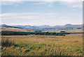
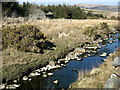
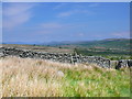
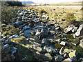
Situated on low ground to the north of a natural spur the stone stands close to a stream that meanders along the valley floor east to west before following alongside an agricultural track way to the south. This is a wide and open landscape with undulating terrain that is rich in prehistoric activity, and the land owner was most helpful during my visit (I had contacted him prior to my visit).
The stone stands at 1.10m. It has a 1m base that tapers to a rounded top and it's depth is 0.26m. The shape is quite typical for the area. There are markings on the northern side but these appear glacially caused. Of interest is the presence of a stone row 100m to the SSE. The two sites are not visible from their respective locations due to the crest of the grassy spur but they appear aligned when viewed from a halfway point between them.
You may be viewing yesterday's version of this page. To see the most up to date information please register for a free account.
")
")
")
")
Do not use the above information on other web sites or publications without permission of the contributor.
Nearby Images from Geograph Britain and Ireland:
©2010(licence)
©2007(licence)
©2007(licence)
©2014(licence)
©2007(licence)
The above images may not be of the site on this page, they are loaded from Geograph.
Please Submit an Image of this site or go out and take one for us!
Click here to see more info for this site
Nearby sites
Key: Red: member's photo, Blue: 3rd party photo, Yellow: other image, Green: no photo - please go there and take one, Grey: site destroyed
Download sites to:
KML (Google Earth)
GPX (GPS waypoints)
CSV (Garmin/Navman)
CSV (Excel)
To unlock full downloads you need to sign up as a Contributory Member. Otherwise downloads are limited to 50 sites.
Turn off the page maps and other distractions
Nearby sites listing. In the following links * = Image available
96m S 169° Ffridd Bryn Coch Stone Row* Stone Row / Alignment (SH6956628311)
180m SSW 192° Ffridd Bryn Coch Round Cairn 2* Round Cairn (SH6950928231)
193m S 185° Ffridd Bryn Coch Cairn Field* Barrow Cemetery (SH6952728214)
399m SW 220° Afon Gam Cairn Field* Barrow Cemetery (SH6928228109)
654m SW 216° Afon Gam Round Cairn 1* Round Cairn (SH6915127887)
736m SW 220° Afon Gam Round Cairn 2* Round Cairn (SH6906127854)
794m SW 226° Afon Gam Round Cairn 3* Round Cairn (SH6895827875)
827m SW 231° Afon Gam Round Cairn 4* Round Cairn (SH6889427900)
884m SSW 211° Ffridd Bryn Coch Recumbent Stones* Stone Row / Alignment (SH6907327660)
885m SSW 211° Ffridd Bryn Coch Round Cairn 1* Round Cairn (SH6907327659)
1.0km S 183° Craig Aberserw Round Cairn* Round Cairn (SH6947227381)
1.0km SW 214° Afon Gam Rock Art* Rock Art (SH6895027570)
1.1km NNE 21° Crawcwellt Hut Circle South 2* Ancient Village or Settlement (SH6999129462)
1.2km NNE 21° Hut Circle Settlement at Crawcwellt South* Ancient Village or Settlement (SH7000029500)
1.2km NNE 18° Crawcwellt Hut Circle South 1* Ancient Village or Settlement (SH6995529534)
1.3km SW 227° Ceunant Coch Stones* Natural Stone / Erratic / Other Natural Feature (SH6854627525)
1.3km SW 227° Ceunant Coch Round Cairn 1* Round Cairn (SH6854627507)
1.5km SW 219° Ceunant Coch Round Cairn 2* Round Cairn (SH6856427259)
2.1km NNW 343° Crawcwellt Ancient Settlement* Ancient Village or Settlement (SH6899430425)
2.1km N 354° Crawcwellt Cairn 6* Cairn (SH6939830535)
2.2km N 2° Crawcwellt Iron Age Settlement South East* Ancient Village or Settlement (SH69703065)
2.3km N 360° Standing Stone South of Blaen Y Cae* Standing Stone (Menhir) (SH69603070)
2.6km NNW 339° Crawcwellt Ring Cairn* Ring Cairn (SH6869330816)
2.6km NNW 337° Crawcwellt Hut Circle Settlement North* Ancient Village or Settlement (SH686308)
2.6km NNW 338° Crawcwellt Cairn 1* Cairn (SH6866430825)
View more nearby sites and additional images


 We would like to know more about this location. Please feel free to add a brief description and any relevant information in your own language.
 Wir möchten mehr über diese Stätte erfahren. Bitte zögern Sie nicht, eine kurze Beschreibung und relevante Informationen in Deutsch hinzuzufügen.
 Nous aimerions en savoir encore un peu sur les lieux. S'il vous plaît n'hesitez pas à ajouter une courte description et tous les renseignements pertinents dans votre propre langue.
 Quisieramos informarnos un poco más de las lugares. No dude en añadir una breve descripción y otros datos relevantes en su propio idioma.