

<< Our Photo Pages >> Crawcwellt Iron Age Settlement South East - Ancient Village or Settlement in Wales in Gwynedd
Submitted by TAlanJones on Thursday, 10 February 2022 Page Views: 424
Multi-periodSite Name: Crawcwellt Iron Age Settlement South EastCountry: Wales County: Gwynedd Type: Ancient Village or Settlement
Nearest Town: Trawsfynydd Nearest Village: Ganllwyd
Map Ref: SH69703065
Latitude: 52.857524N Longitude: 3.936699W
Condition:
| 5 | Perfect |
| 4 | Almost Perfect |
| 3 | Reasonable but with some damage |
| 2 | Ruined but still recognisable as an ancient site |
| 1 | Pretty much destroyed, possibly visible as crop marks |
| 0 | No data. |
| -1 | Completely destroyed |
| 5 | Superb |
| 4 | Good |
| 3 | Ordinary |
| 2 | Not Good |
| 1 | Awful |
| 0 | No data. |
| 5 | Can be driven to, probably with disabled access |
| 4 | Short walk on a footpath |
| 3 | Requiring a bit more of a walk |
| 2 | A long walk |
| 1 | In the middle of nowhere, a nightmare to find |
| 0 | No data. |
| 5 | co-ordinates taken by GPS or official recorded co-ordinates |
| 4 | co-ordinates scaled from a detailed map |
| 3 | co-ordinates scaled from a bad map |
| 2 | co-ordinates of the nearest village |
| 1 | co-ordinates of the nearest town |
| 0 | no data |
Internal Links:
External Links:
")
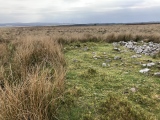
Situated to the south of the country lane that leads from the A470 to the Rhinog mountain car park at Graigddu Isaf the settlement lies within a high moorland environment. This is one of several identified prehistoric settlements within the Crawcwellt area. Apparently the archaeological area of interest covers 14 acres but to date only 2% has been excavated. From my observations I doubt that this particular settlement site has attracted much archaeological attention.
The settlement appears to have been quite large. Although difficult to interpret the site does offer evidence of a hut circle settlement, i.e there are raised platforms, circular structures and wall enclosures. However, I do wonder if some of my interpretations are more to do with wishful thinking as opposed to a structured analysis 😊
Although the environment itself offers panoramic views in all directions the settlement site itself is not that impressive.
You may be viewing yesterday's version of this page. To see the most up to date information please register for a free account.
")
")
")
")
")
")
")
")
Do not use the above information on other web sites or publications without permission of the contributor.
Click here to see more info for this site
Nearby sites
Key: Red: member's photo, Blue: 3rd party photo, Yellow: other image, Green: no photo - please go there and take one, Grey: site destroyed
Download sites to:
KML (Google Earth)
GPX (GPS waypoints)
CSV (Garmin/Navman)
CSV (Excel)
To unlock full downloads you need to sign up as a Contributory Member. Otherwise downloads are limited to 50 sites.
Turn off the page maps and other distractions
Nearby sites listing. In the following links * = Image available
112m WNW 295° Standing Stone South of Blaen Y Cae* Standing Stone (Menhir) (SH69603070)
322m WSW 248° Crawcwellt Cairn 6* Cairn (SH6939830535)
739m WSW 251° Crawcwellt Ancient Settlement* Ancient Village or Settlement (SH6899430425)
904m WNW 291° Crawcwellt Cairn 2* Cairn (SH6886531002)
1.0km W 278° Crawcwellt Ring Cairn* Ring Cairn (SH6869330816)
1.0km W 278° Crawcwellt Cairn 1* Cairn (SH6866430825)
1.1km W 279° Crawcwellt Kerb Cairn* Cairn (SH68653085)
1.1km WNW 282° Iron Smelting Hut Crawcwellt West* Ancient Village or Settlement (SH68653090)
1.1km W 276° Crawcwellt Hut Circle Settlement North* Ancient Village or Settlement (SH686308)
1.1km WNW 283° Crawcwellt Cairn 4* Cairn (SH6860730938)
1.1km SSE 166° Crawcwellt Hut Circle South 1* Ancient Village or Settlement (SH6995529534)
1.2km SSE 164° Hut Circle Settlement at Crawcwellt South* Ancient Village or Settlement (SH7000029500)
1.2km NNW 329° Brynteg Recumbent* Standing Stone (Menhir) (SH691317)
1.2km SSE 165° Crawcwellt Hut Circle South 2* Ancient Village or Settlement (SH6999129462)
1.3km NW 324° Brynteg Settlement* Ancient Village or Settlement (SH68953175)
1.4km NW 306° Moel Y Gwartheg Cairn 9* Cairn (SH6859631511)
1.4km NW 310° Moel Y Gwartheg Cairn Cemetery* Barrow Cemetery (SH6864431599)
1.4km NW 308° Moel Y Gwartheg Cairn 8* Cairn (SH6858631555)
1.4km NW 310° Moel Y Gwartheg Ring Cairn* Ring Cairn (SH6862131617)
1.5km NW 309° Moel Y Gwartheg Cairn 7* Cairn (SH6858331591)
1.5km NW 313° Moel Y Gwartheg Cairn 5* Cairn (SH6861431728)
2.0km NNE 18° Eden Standing Stone* Standing Stone (Menhir) (SH70373250)
2.2km S 182° Ffridd Bryn Coch Standing Stone* Standing Stone (Menhir) (SH6955028406)
2.3km S 182° Ffridd Bryn Coch Stone Row* Stone Row / Alignment (SH6956628311)
2.4km S 183° Ffridd Bryn Coch Round Cairn 2* Round Cairn (SH6950928231)
View more nearby sites and additional images


 We would like to know more about this location. Please feel free to add a brief description and any relevant information in your own language.
 Wir möchten mehr über diese Stätte erfahren. Bitte zögern Sie nicht, eine kurze Beschreibung und relevante Informationen in Deutsch hinzuzufügen.
 Nous aimerions en savoir encore un peu sur les lieux. S'il vous plaît n'hesitez pas à ajouter une courte description et tous les renseignements pertinents dans votre propre langue.
 Quisieramos informarnos un poco más de las lugares. No dude en añadir una breve descripción y otros datos relevantes en su propio idioma.