Featured: Ark of Secrets - Neolithic spirit alive in the Middle Ages

Ark of Secrets - Neolithic spirit alive in the Middle Ages

Random Image


North Ballachulish

Stone Circles, A Modern Builder's Guide

Stone Circles, A Modern Builder's Guide

Who's Online

There are currently, 484 guests and 1 members online.

You are a guest. To join in, please register for free by clicking here

Sponsors

<< Our Photo Pages >> Bellever Tor NE Settlement - Ancient Village or Settlement in England in Devon

Submitted by Andy B on Friday, 28 August 2009  Page Views: 23300

Multi-periodSite Name: Bellever Tor NE Settlement
Country: England
NOTE: This site is 0.973 km away from the location you searched for.

County: Devon Type: Ancient Village or Settlement
Nearest Town: Tavistock / Chagford  Nearest Village: Bellever
Map Ref: SX64867675
Latitude: 50.574816N  Longitude: 3.909887W
Condition:
5Perfect
4Almost Perfect
3Reasonable but with some damage
2Ruined but still recognisable as an ancient site
1Pretty much destroyed, possibly visible as crop marks
0No data.
-1Completely destroyed
2 Ambience:
5Superb
4Good
3Ordinary
2Not Good
1Awful
0No data.
3 Access:
5Can be driven to, probably with disabled access
4Short walk on a footpath
3Requiring a bit more of a walk
2A long walk
1In the middle of nowhere, a nightmare to find
0No data.
3 Accuracy:
5co-ordinates taken by GPS or official recorded co-ordinates
4co-ordinates scaled from a detailed map
3co-ordinates scaled from a bad map
2co-ordinates of the nearest village
1co-ordinates of the nearest town
0no data
4

Internal Links:
External Links:

Bellever Tor NE Settlement
Bellever Tor NE Settlement submitted by Andy B : Excavation of Bellever round house Photo copyright Dartmoor National Park Authority (Vote or comment on this photo)
Ancient Settlement in Devon. The nearest proper road is a couple of miles away. The toilet is an energetic yomp down a steep slope and through the conifers. When it rains – and here on Dartmoor it really does pelt down – the only shelter is project supervisor Simon Hughes's old VW Golf. "It's started to smell like a dead dog," he says with a big grin.

Despite the tough conditions, Hughes and his team are relishing working on the Bellever roundhouse. "It's a great project for us," he says. "It's a chance to really try to find out what was going on here 3,500 years ago."

There are lots of roundhouses on Dartmoor (5,000 stone ones and more wooden ones that have rotted away without leaving any trace), but most were studied a century or more ago. They used to dig one a day then, rather than taking weeks over it as they do now.

So when two years ago a great storm felled a plantation of conifers at Bellever, disturbing the roundhouse's granite structure, archaeologists argued that they ought to have another look. It is an exciting project: only the second roundhouse to be excavated in the area in the last 20 years and a chance to learn more about the people who, at a time when the climate was much more clement than it is now, were able to live and work here.

By the time the bronze-age people arrived on Dartmoor, the slopes had been cleared of trees so that crops could be grown and animals – cattle and sheep – grazed. Blocks of land may have been controlled by groupings of people or tribes. Some of the roundhouses have porches, protection against the weather, others seem to have been divided into rooms. Roofs built from timber may have been covered in turf, heather, gorse or thatch.

In October 2011, the Dartmoor National Park Authority commissioned a small excavation here by a professional firm of consultants, AC Archaeology. Just under a quarter of the house, which has a diameter of 8m, was dug but many interesting and well-preserved features, including a mysterious nearby cairn and well-preserved paved flooring made up of granite slabs, were found.
Source: The Guardian

Update August 2019: This settlement is featured on the Prehistoric Dartmoor Walks (PDW) website - see their entry for Bellever Settlement. This settlement and related field system are also scheduled as Historic England List ID 1018512 and recorded as Pastscape Monument No. 442623.
You may be viewing yesterday's version of this page. To see the most up to date information please register for a free account.

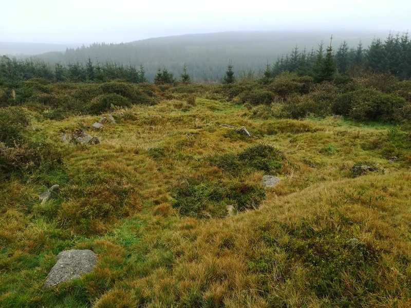
Bellever Tor NE Settlement
Bellever Tor NE Settlement submitted by Bladup : Bellever Tor NE Settlement, The wonderful large Western Hut - SX64867675 (Vote or comment on this photo)

Bellever Tor NE Settlement
Bellever Tor NE Settlement submitted by Bladup : Bellever Tor NE Settlement, Looking East over the Eastern Hut from the Western Hut (SX64867675) (Vote or comment on this photo)

Bellever Tor NE Settlement
Bellever Tor NE Settlement submitted by Bladup : Bellever Tor NE Settlement, SX64867675, Some sort of structure seems to connect the two huts (Vote or comment on this photo)

Bellever Tor NE Settlement
Bellever Tor NE Settlement submitted by Bladup : Bellever Tor NE Settlement, The fab hut at SX64867675, I fell off a slimy tree stump taking this shot! (Vote or comment on this photo)

Bellever Tor NE Settlement
Bellever Tor NE Settlement submitted by Bladup : Bellever Tor NE Settlement, The Smaller less defined Eastern Hut at SX64877675 (Vote or comment on this photo)

Bellever Tor NE Settlement
Bellever Tor NE Settlement submitted by Bladup : Bellever Tor NE Settlement, The Excavated Hut at SX64867675

Bellever Tor NE Settlement
Bellever Tor NE Settlement submitted by Bladup : Bellever Tor NE Settlement, The Hut at SX64777681

Bellever Tor NE Settlement
Bellever Tor NE Settlement submitted by Bladup : Bellever Tor NE Settlement, The very overgrown Hut at SX64707677, You can see it when your there, less so in a photo!

Bellever Tor NE Settlement
Bellever Tor NE Settlement submitted by Bladup : Bellever Tor NE Settlement, The Hut at SX64797675

Bellever Tor NE Settlement
Bellever Tor NE Settlement submitted by Bladup

Bellever Tor NE Settlement
Bellever Tor NE Settlement submitted by Bladup : Bellever Tor NE Settlement, The Hut at SX 64827690

Bellever Tor NE Settlement
Bellever Tor NE Settlement submitted by Bladup

Bellever Tor NE Settlement
Bellever Tor NE Settlement submitted by Bladup : Bellever Tor NE Settlement, The hut at SX648766

Bellever Tor NE Settlement
Bellever Tor NE Settlement submitted by Andy B : Bellever hut circle Photo copyright Dartmoor National Park Authority

Do not use the above information on other web sites or publications without permission of the contributor.
Click here to see more info for this site

Nearby sites

Click here to view sites on an interactive OS map

Key: Red: member's photo, Blue: 3rd party photo, Yellow: other image, Green: no photo - please go there and take one, Grey: site destroyed

Download sites to:
KML (Google Earth)
GPX (GPS waypoints)
CSV (Garmin/Navman)
CSV (Excel)

To unlock full downloads you need to sign up as a Contributory Member. Otherwise downloads are limited to 50 sites.


Turn off the page maps and other distractions

Nearby sites listing. In the following links * = Image available
 385m W 279° Bellever Tor N Settlement* Ancient Village or Settlement (SX64487682)
 451m NNW 340° Lakehead Hill Cairn 8* Cairn (SX6471777178)
 604m NNW 332° Lakehead Hill South Hut Circle* Ancient Village or Settlement (SX6459177291)
 655m NNW 346° Lakehead Hill Cairn 7* Cairn (SX6471477389)
 669m NNW 345° Lakehead Hill SE Stone Row* Stone Row / Alignment (SX64707740)
 820m WSW 248° Bellever Tor Cairn one* Cist (SX6408976465)
 864m SW 235° Bellever Tor 2* Cairn (SX6414076270)
 873m NW 308° Lakehead Hill South West Stone Row / Alignment (SX64187730)
 874m NW 324° Lakehead Hill 6* Cairn (SX6435877467)
 897m NW 324° Lakehead Hill 5* Stone Circle (SX6434677486)
 927m NNW 335° Lakehead Hill E* Stone Row / Alignment (SX6449577603)
 966m NNW 330° Lakehead Hill* Stone Row / Alignment (SX644776)
 1.0km NNW 331° Lakehead Hill W* Stone Row / Alignment (SX6437977653)
 1.1km NW 326° Lakehead Hill 2* Cist (SX6425077696)
 1.1km NNW 332° Lakehead Cairn Circle 1* Ring Cairn (SX6435677766)
 1.2km SW 232° Bellever Tor 3* Cairn (SX63917606)
 1.2km WSW 250° Black Newtake Enclosure Ancient Village or Settlement (SX63707636)
 1.2km SW 233° Bellever Tor 4* Ring Cairn (SX63867603)
 1.3km SW 226° Bellever Tor 6* Cist (SX63897585)
 1.3km SW 215° Bellever Tor 10* Cist (SX64077568)
 1.4km SSE 165° Laughter Tor row 2* Multiple Stone Rows / Avenue (SX65207538)
 1.4km SSE 164° Laughter Tor Longstone* Standing Stone (Menhir) (SX65227538)
 1.4km SW 223° Bellever Tor 8 Cairn (SX63847572)
 1.5km NNW 341° Kraps Ring* Ancient Village or Settlement (SX64427814)
 1.5km SSE 159° Laughter Tor row 1* Multiple Stone Rows / Avenue (SX65377532)
View more nearby sites and additional images

<< Gräberfeld Eulau

Raven Jahrhundertstein >>

Please add your thoughts on this site

Prehistoric Settlements

Prehistoric Settlements

Sponsors

Auto-Translation (Google)

Translate from English into:

"Bellever Tor NE Settlement" | Login/Create an Account | 4 News and Comments
  
Go back to top of page    Comments are owned by the poster. We aren't responsible for their content.
Archaeologist led walk at Bronze Age Bellever, Sun 22nd July by Andy B on Saturday, 14 July 2012
(User Info | Send a Message)
County: Devon

Sun 22 July; 14.00

Step back into prehistory with Archaeologist Jane Marchand on Sunday 22 July as you walk through Bronze Age Bellever. Learn more about the exceptionally large number of burial and ceremonial sites to be found in this largely forested area and visit the site of a recent hut circle excavation. Location: Meet at 2 pm. Postbridge car park (Ordnance Survey grid reference SX646788). Postbridge is located on the B3212 between Moretonhampstead and Two Bridges/Princetown

Org: Dartmoor National Park Authority
Name: High Moorland Visitor Centre
Tel: 01822 890414
Web: http://www.dartmoor.gov.uk

Part of the Festival of British Archaeology 2012
[ Reply to This ]

Archaeologists continue dig at Bellever by Andy B on Tuesday, 23 August 2011
(User Info | Send a Message)
A team of archaeologists began a new phase of excavations on a round house site in Bellever plantation on Dartmoor on Monday 18 July. Organised by Dartmoor National Park Authority (DNPA) with support from the Dartmoor Trust and the Forestry Commission the dig explores the entrance, and directly outside the round house excavated a couple of years ago. A small badly damaged round house close by and its relationship with a nearby field boundary will also be examined.

To help visitors enjoy the wonderful archaeology to be found within the plantation at Bellever, a new booklet has been published by Dartmoor National Park Authority.

The 32 page Guide contains photographs and specially produced colour illustrations by local artist Carol Mullin. There are maps and a detailed gazetteer of numbered sites, corresponding with numbered posts located at sites within the plantation. It is available at the National Park Information Centres or from the Authority’s online shop.

The popular Going for Bronze Exhibition, a partnership exhibition between DNPA and the Royal Albert Memorial Museum (RAMM), Exeter, has been updated. The exhibition tells the story of life, death and landscape during Dartmoor’s Bronze Age.

New displays have been added for 2011, including an update on the findings from previous excavations of the round house within Bellever plantation and the results of the Time Team investigations of a prehistoric ceremonial complex at Tottiford Reservoir in August 2010. Flint tools discovered at Tottiford will also be on show.

The exhibition is on display at the National Park Information Centre, Postbridge, for the summer season.

Previous excavations on the round house discovered that a cairn had been built on top of part of the round house, suggesting it had been deliberately abandoned. Beneath this a well constructed paved stone floor lay immediately inside the entrance, and eleven post holes forming a ring inside the wall which would have supported the roof. Over 80 smaller stake holes were also found indicating the existence of an internal wall lining.Within the interior of the round house over 150 sherds of Trevisker ware pottery were found.Fragments of burnt oak and hazel produced carbon dates showing that the house was occupied for around 400 years, from 1,600BC Analysis of ancient pollen had suggested that its Bronze Age occupants were pastoral farmers whose livestock were grazing the surrounding grassland.

Going for Bronze tells the story of life, death and landscape during Dartmoor’s Bronze Age which spans the years between 2,300-700BC. There are a number of illustrative coloured panels, plus a display of artefacts, all found on Dartmoor, from RAMM’s collection, show the change from stone to bronze for tools and weapons. There is also a superb display of replica bronze weapons, including a replica Hameldon dagger, one of the most important artefacts ever found on Dartmoor.

The Exhibition also contains a replica Bronze Age cooking pot, made by local potter, Joss Hibbs, with an accompanying video.

For maps, guide books, trail guides, clothing and other Dartmoor merchandise visit Dartmoor National Park Authority’s Online Shop
http://www.nationalparks.gov.uk/dnpa_shop/main.asp
[ Reply to This ]

Re: Bellever round house, Dartmoor by MikeAitch on Sunday, 17 July 2011
(User Info | Send a Message)
Short BBC news article Re dig.
[ Reply to This ]

Bellever round house, Dartmoor by Andy B on Thursday, 07 July 2011
(User Info | Send a Message)
Archaeological feature of the month – July Bellever round house, Dartmoor

This Bronze Age round house in the Bellever plantation at SX64867674 has been the focus of a fascinating archaeological excavation for the past few years. As a result of winter storm damage in 2007, archaeologists have been carefully investigating the impact both past forestry operations and the storm have had on the round house and have discovered lots of information about life on Dartmoor during the Bronze Age around 3,500 years ago.

(visit their page here to access the linked PDF documents)

The round house is likely to have been occupied by livestock farmers, whose animals would have grazed in the surrounding fields (the boundaries of which still survive) and on nearby open grassland. Over 150 sherds of pottery were recovered during the excavation. The majority of the sherds belong to a type known as "Trevisker ware" and many showed signs of decoration. The excavation also recovered pieces of charcoal that have been radio carbon dated. The dates indicate that the round house was lived in from 1600BC to around 1200BC.

Other features identified included a well preserved paved floor, a ring of post holes for roof supports, door jambs, a perimeter ring of stake holes for an inner lining and a possible ritual abandonment cairn.

This year archaeologists will be returning to Bellever to investigate the area outside the round house, including some of the field boundaries and a smaller circular structure nearby. The excavation is due to take place in July and an open day will be held on Saturday 23 July as part of the Celebrations of the Festival of British Archaeology (external website, opens new window). A series of guided walks to the site will also be taking place on the 22 and 23 of July and Saturday 30 July.

More information about the round house excavation and the Bronze Age on Dartmoor can be found at the Postbridge Information Centre where the "Going for Bronze" exhibition is currently on display. This exhibition contains Bronze Age artefacts found on the moor and from Bellever, as well as beautiful replica bronze weapons.

There are over 5000 round houses known to exist on Dartmoor. A pocket guide about these monuments is available and can be brought from our online shop (external website, opens new window). A detailed guide to the archaeology of Bellever has recently been produced and is also available to buy online (external website, opens new window) or from one of our information centres. For more information on Bellever Plantation visit http://www.forestry.gov.uk/southwestengland .

http://www.dartmoor-npa.gov.uk/lookingafter/laf-culturalheritage/laf-archaeology/feature-of-the-month-july
[ Reply to This ]

Your Name: Anonymous [ Register Now ]
Subject:


Add your comment or contribution to this page. Spam or offensive posts are deleted immediately, don't even bother

<<< What is five plus one as a number? (Please type the answer to this question in the little box on the left)
You can also embed videos and other things. For Youtube please copy and paste the 'embed code'.
For Google Street View please include Street View in the text.
Create a web link like this: <a href="https://www.megalithic.co.uk">This is a link</a>  

Allowed HTML is:
<p> <b> <i> <a> <img> <em> <br> <strong> <blockquote> <tt> <li> <ol> <ul> <object> <param> <embed> <iframe>

We would like to know more about this location. Please feel free to add a brief description and any relevant information in your own language.
Wir möchten mehr über diese Stätte erfahren. Bitte zögern Sie nicht, eine kurze Beschreibung und relevante Informationen in Deutsch hinzuzufügen.
Nous aimerions en savoir encore un peu sur les lieux. S'il vous plaît n'hesitez pas à ajouter une courte description et tous les renseignements pertinents dans votre propre langue.
Quisieramos informarnos un poco más de las lugares. No dude en añadir una breve descripción y otros datos relevantes en su propio idioma.