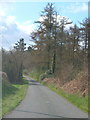
<< Our Photo Pages >> Tottiford Reservoir cairns - Cairn in England in Devon
Submitted by TheCaptain on Saturday, 10 September 2022 Page Views: 295
Neolithic and Bronze AgeSite Name: Tottiford Reservoir cairnsCountry: England
NOTE: This site is 5.16 km away from the location you searched for.
County: Devon Type: Cairn
Nearest Town: Bovey Tracey Nearest Village: Hennock
Map Ref: SX81138312
Latitude: 50.635616N Longitude: 3.682266W
Condition:
| 5 | Perfect |
| 4 | Almost Perfect |
| 3 | Reasonable but with some damage |
| 2 | Ruined but still recognisable as an ancient site |
| 1 | Pretty much destroyed, possibly visible as crop marks |
| 0 | No data. |
| -1 | Completely destroyed |
| 5 | Superb |
| 4 | Good |
| 3 | Ordinary |
| 2 | Not Good |
| 1 | Awful |
| 0 | No data. |
| 5 | Can be driven to, probably with disabled access |
| 4 | Short walk on a footpath |
| 3 | Requiring a bit more of a walk |
| 2 | A long walk |
| 1 | In the middle of nowhere, a nightmare to find |
| 0 | No data. |
| 5 | co-ordinates taken by GPS or official recorded co-ordinates |
| 4 | co-ordinates scaled from a detailed map |
| 3 | co-ordinates scaled from a bad map |
| 2 | co-ordinates of the nearest village |
| 1 | co-ordinates of the nearest town |
| 0 | no data |
Internal Links:
External Links:
I have visited· I would like to visit
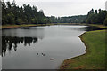
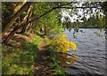
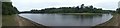
TheCaptain visited on 7th Sep 2022 - their rating: Cond: 2 Amb: 4 Access: 2 To the east of the mound, between it and the eastern shore, can be seen several round piles of stones, which may be ancient cairns, but I am not too convinced, as they look neither big enough, and seem strangely spaced and positioned in what would have been a wet position. There seemes to be a fairly regularly spaced row of these stone piles along much of the eastern shoreline. Watching the Time Team program later and they showed that these were more likely relatively modern stone piles, possibly something to do with when the reservoir was being created.
")
To the east of the Tottiford Reservoir mound, between it and the eastern shore, can be seen several round piles of stones, which may be ancient cairns, but I am not too convinced, as they look neither big enough, and seem strangely spaced and positioned in what would have been a wet position.
There seemes to be a fairly regularly spaced row of these stone piles along much of the eastern shoreline. Watching the Time Team program later and they showed that these were relatively modern stone piles, possibly something to do with when the reservoir was being created.
From heritagegateway.org
Line of roughly circular dumps of stone fragments along the eastern side of the reservoir, some appearing to be associated with features in the prehistoric complex; these were initial thought to be cairns. Excavation revealed they are much more modern in date and may instead be clearance cairns related to agricultural activity or stone dumps associated with the late 19th century construction of the reservoir.
You may be viewing yesterday's version of this page. To see the most up to date information please register for a free account.
")
")
")
Do not use the above information on other web sites or publications without permission of the contributor.
Nearby Images from Geograph Britain and Ireland:
©2016(licence)
©2020(licence)
©2012(licence)
©2020(licence)
©2006(licence)
The above images may not be of the site on this page, they are loaded from Geograph.
Please Submit an Image of this site or go out and take one for us!
Click here to see more info for this site
Nearby sites
Key: Red: member's photo, Blue: 3rd party photo, Yellow: other image, Green: no photo - please go there and take one, Grey: site destroyed
Download sites to:
KML (Google Earth)
GPX (GPS waypoints)
CSV (Garmin/Navman)
CSV (Excel)
To unlock full downloads you need to sign up as a Contributory Member. Otherwise downloads are limited to 50 sites.
Turn off the page maps and other distractions
Nearby sites listing. In the following links * = Image available
22m WNW 295° Tottiford Reservoir mound* Ancient Village or Settlement (SX81118313)
30m S 178° Tottiford Reservoir Row S* Stone Row / Alignment (SX81138309)
45m WNW 295° Tottiford Reservoir circle* Stone Circle (SX81098314)
100m NW 322° Tottiford Reservoir Row N* Stone Row / Alignment (SX81078320)
439m SSW 196° Tottiford Reservoir* Standing Stones (SX810827)
3.0km WSW 236° Bishop's Stone (Lustleigh)* Ancient Cross (SX7860281532)
3.2km SW 234° Datuidoc's Stone* Early Christian Sculptured Stone (SX7850081274)
3.4km W 259° Higher Combe Cross* Ancient Cross (SX7776482535)
4.0km WSW 256° South Harton Cross* Ancient Cross (SX7724982273)
4.3km S 175° The Bovey Stone Ancient Cross (SX8141778843)
4.3km W 275° Sanduck Cross* Ancient Cross (SX7681983610)
4.6km SSE 168° St Mary's Well (Bovey Tracey)* Holy Well or Sacred Spring (SX820786)
5.0km W 261° Hunter's Tor Fort* Hillfort (SX7616482412)
5.4km WNW 294° One Mill Bridge Cross* Ancient Cross (SX76268544)
5.9km SW 228° Trendlebere Down* Multiple Stone Rows / Avenue (SX76627928)
5.9km NW 312° Mardon Down Cairn 1* Cairn (SX76768716)
5.9km SW 228° Trendlebere Down Stone Row Cairn* Cairn (SX7662079230)
6.0km NW 312° Mardon Down S* Stone Circle (SX76768719)
6.0km NW 312° Mardon Down Ring Cairn* Ring Cairn (SX7672987264)
6.0km NW 313° Mardon Down Mortar Pit* Modern Stone Circle etc (SX76808735)
6.1km NW 313° Mardon Down Cairn 3* Cairn (SX7677487432)
6.1km NW 314° The Giant's Grave Mardon Down* Cairn (SX76768746)
6.2km NW 315° Marden Down East* Ring Cairn (SX76908760)
6.2km NW 318° Headless Cross (Moretonhampstead)* Modern Stone Circle etc (SX77068781)
6.3km NW 315° Mardon Down N* Stone Circle (SX76758768)
View more nearby sites and additional images


 We would like to know more about this location. Please feel free to add a brief description and any relevant information in your own language.
 Wir möchten mehr über diese Stätte erfahren. Bitte zögern Sie nicht, eine kurze Beschreibung und relevante Informationen in Deutsch hinzuzufügen.
 Nous aimerions en savoir encore un peu sur les lieux. S'il vous plaît n'hesitez pas à ajouter une courte description et tous les renseignements pertinents dans votre propre langue.
 Quisieramos informarnos un poco más de las lugares. No dude en añadir una breve descripción y otros datos relevantes en su propio idioma.