Featured: Friendly specialist tours to ancient, mystical and historical sites in the UK and beyond

Friendly specialist tours to ancient, mystical and historical sites in the UK and beyond

Sign the Petition to protest against building a Hotel on Castle Hill hillfort

Sign the Petition to protest against building a Hotel on Castle Hill hillfort

Who's Online

There are currently, 230 guests and 0 members online.

You are a guest. To join in, please register for free by clicking here

Sponsors

<< Our Photo Pages >> Trendlebere Down - Multiple Stone Rows / Avenue in England in Devon

Submitted by AngieLake on Monday, 30 September 2002  Page Views: 10120

Neolithic and Bronze AgeSite Name: Trendlebere Down Alternative Name: Black Hill stone row
Country: England County: Devon Type: Multiple Stone Rows / Avenue
Nearest Town: Bovey Tracey  Nearest Village: Water / Haytor
Map Ref: SX76627928  Landranger Map Number: 191
Latitude: 50.600162N  Longitude: 3.744732W
Condition:
5Perfect
4Almost Perfect
3Reasonable but with some damage
2Ruined but still recognisable as an ancient site
1Pretty much destroyed, possibly visible as crop marks
0No data.
-1Completely destroyed
3 Ambience:
5Superb
4Good
3Ordinary
2Not Good
1Awful
0No data.
3 Access:
5Can be driven to, probably with disabled access
4Short walk on a footpath
3Requiring a bit more of a walk
2A long walk
1In the middle of nowhere, a nightmare to find
0No data.
4 Accuracy:
5co-ordinates taken by GPS or official recorded co-ordinates
4co-ordinates scaled from a detailed map
3co-ordinates scaled from a bad map
2co-ordinates of the nearest village
1co-ordinates of the nearest town
0no data
5

Internal Links:
External Links:

I have visited· I would like to visit

TheCaptain visited on 7th Sep 2022 - their rating: Cond: 3 Amb: 3 Access: 4 Getting from the road to find this row is a bit of a struggle through gorse and heather, and I initially found it hard to find. But there it is, not quite where I was expecting to find it, but as so often with a path running down beside it, and it has had much of the growth mechanically cleared from it. The large cairn at the top is completely overgrown, as is the top of the row, but I found a few fairly large fallen stones hidden underneath the overgrowth. Further down, the row becomes more cleared, but the stones are smaller, mostly flat on the ground, and many have been substantially damaged by the mechanical machines used to clear the gorse and heather. The bottom end again becomes lost in high vegetation. Amongst the disturbance is a large stone, facing across the rows, which looks as though it may have once been a terminal blocking stone. All in all a disappointment.

SandyG visited on 21st Jan 2017 - their rating: Cond: 2 Amb: 4 Access: 4 Car parking is available at SX 76661 79035. From the car parking area walk northward along the road verge for about 200m . The row is a short distance below (north) of the road.

AngieLake have visited here

Average ratings for this site from all visit loggers: Condition: 2.5 Ambience: 3.5 Access: 4
Trendlebere Down
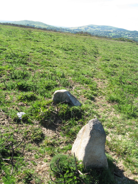
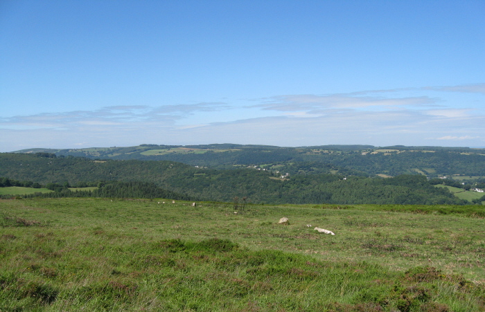
Trendlebere Down submitted by AngieLake : First view of Trendlebere Down stone row on approach from the road. Orientated N-S, the south end is to far right here. (Vote or comment on this photo)
Double Stone Row in Devon. The approach to the stone row is down a slope from the road, under Black Hill. Apparently an associated cairn was situated 10m north of the road, and is "barely recognizable, merely a low crescent of earth with a few stones embedded in the turf." [Butler].

The 'way to go' to find Trendlebere Down stone row. (On my OS map - 'Outdoor Leisure 28 Dartmoor', its by the yellow road that leads north from Haytor Vale. I found a good parking space on the left, past North Lodge, and walked the rest of the way.)

Update August 2019: This stone row is featured on the Prehistoric Dartmoor Walks (PDW) website - see their entry for the Trendlebere Down Stone Row, which tells us: "A stone row 100ft. to the north of the Haytor-Manaton road. 18 stones of the stone row can be identified of which 9 are fallen and 9 upright stones. The fallen stones vary in length between 3'4" and 4'6"; the upright ones between 6" and 2'4".

It is also recorded as part of the record for Pastscape Monument No. 444981 (Bronze Age stone row, the remains of a cairn and the site of a cairn), as MDV8076 (Alignment on Trendlebeare Down) on the Devon and Dartmoor HER, and scheduled as part of Historic England List ID 1003056 (Stoner row N of Yarner Wells).

The row also has a record on the Stone Rows of Great Britain website: Trendlebere Down Stone Row, which includes a description, photographs and a plan of the row and its terminal cairns.
You may be viewing yesterday's version of this page. To see the most up to date information please register for a free account.
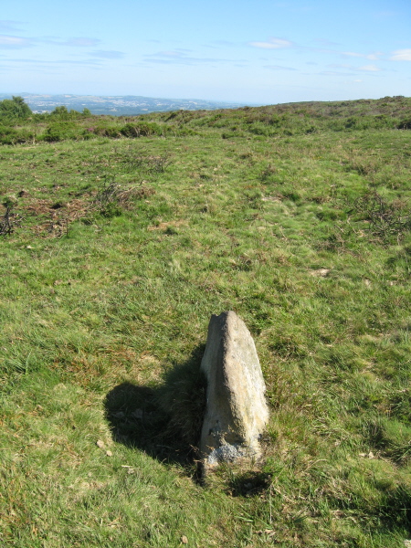
Trendlebere Down
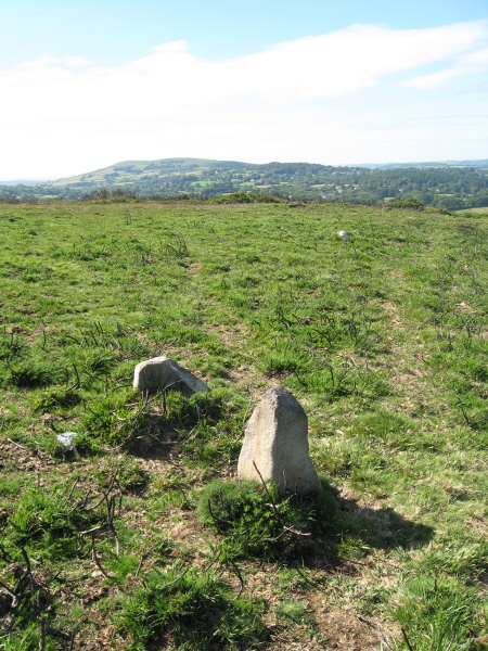
Trendlebere Down submitted by AngieLake : In this view, the taller stone of this pair (which stand side-by-side [E-W] further north in the row), points to distant Manaton Church at an angle of approx 324 degs. (Vote or comment on this photo)

Trendlebere Down
Trendlebere Down submitted by AngieLake : Checking some orientations: Viewed from its west side, this stone a little further south in the row from the previous one angled on a harbour, points 140 degs, towards Torbay. (Vote or comment on this photo)

Trendlebere Down
Trendlebere Down submitted by AngieLake : Checking some orientations: Viewed from its west side, this stone points directly to the mouth of the River Teign at Teignmouth (110 degs). (Vote or comment on this photo)

Trendlebere Down
Trendlebere Down submitted by AngieLake : Checking some orientations that day: Viewed from their east side, the two stones that stood side by side [E - W] further north up the row align with the prominent distant rocky tor framed between the two hills. (Vote or comment on this photo)

Trendlebere Down
Trendlebere Down submitted by AngieLake : Checked the orientation of some of the stones that day. Viewed from its east side, the larger, fallen one pointed 293 degs towards a prominent distant rocky tor framed by two hills.

Trendlebere Down
Trendlebere Down submitted by AngieLake : These two stones [the one at top of photo is quite small here] are the furthest south in the row - or the furthest south I could see on that day in July. Maybe there are some hidden in the undergrowth? (Butler shows more in his plan than are visible on site.) The track up to the road is just to the right of this shot. A few yards behind me is the larger, fallen stone. (Measured row's orien...

Trendlebere Down Stone Row Cairn
Trendlebere Down Stone Row Cairn submitted by bec-zog : Black Hill Stone Row & Cairn. SX767,793. Bronze age burial cairn with 16 stone row extending N, plus either a terminator stone or remains of a second stone row. A further cairn located at S end

Trendlebere Down
Trendlebere Down submitted by TheCaptain : The bottom end of the row is very disturbed, with a sort of gulley cutting through it, and some high vegetation. Amongst the disturbance is this large stone, facing across the rows, which looks as though it may have once been a terminal blocking stone.

Trendlebere Down
Trendlebere Down submitted by TheCaptain : Looking northwards down the bottom end of the row

Trendlebere Down
Trendlebere Down submitted by TheCaptain : Looking back up the row nearing the lower end, several stones can be found here, showing the original double nature of the row. Many of the stones here have been substantially damaged by the mechanical machines used to clear the gorse and heather, some even "ploughed" right out, one of which can be seen over on the left hand side.

Trendlebere Down
Trendlebere Down submitted by TheCaptain

Trendlebere Down
Trendlebere Down submitted by TheCaptain : Looking back up the row from halfway, a few more stones can be found here

Trendlebere Down
Trendlebere Down submitted by TheCaptain : Now halfway down the row, a few more stones can be found

Trendlebere Down
Trendlebere Down submitted by TheCaptain : Looking northwards down the length of the row

Trendlebere Down
Trendlebere Down submitted by TheCaptain : Down from the overgrown cairn can be found a couple of fallen stones, part covered by heather and gorse. Looking up the row from here, the cairn shows itself clearly, although it is probably just overgrowth on top of it.

Trendlebere Down
Trendlebere Down submitted by TheCaptain : Looking northwards down the length of the row from the overgrown cairn at the top

Trendlebere Down Stone Row Cairn
Trendlebere Down Stone Row Cairn submitted by TheCaptain : Stood on top of the large overgrown cairn at the top of the stone row, looking down the length of the row.

Trendlebere Down Stone Row Cairn
Trendlebere Down Stone Row Cairn submitted by TheCaptain : The large cairn at the top of the stone row is completely overgrown, as is the top of the row, but I found a few fairly large fallen stones hidden underneath the overgrowth.

Trendlebere Down
Trendlebere Down submitted by AngieLake : Eureka! This row was so hard to find! Last visit in 2010 was after a fire or swaling [controlled burning], I think. Now it's hidden by lush vegetation, and you have to guess which animal track follows it. I had walked along the road above, looking out for it. Then down a footpath and headed off at an angle to where it should have been on the OS map. Then returned to the road again, and event...

Trendlebere Down
Trendlebere Down submitted by AngieLake : At last some stones! I'd been searching for ages for this row, now hidden in the bracken. 17 July. Looking uphill with the eastern flank of Black Hill in background.

Trendlebere Down
Trendlebere Down submitted by AngieLake : What a job it was to find the stones, which were half- or wholly-hidden in the bracken and gorse. In this photo, you can see the next stone in the row, leading south, uphill towards Black Hill in the background. 17 July.

Trendlebere Down
Trendlebere Down submitted by AngieLake : This was a decent sized stone about halfway up the row, but all were half- or wholly- hidden by the bracken and gorse. 17 July.

Trendlebere Down
Trendlebere Down submitted by AngieLake : Looking downhill along the hidden row, from this stone approx half way up the row, towards North. 17 July.

Trendlebere Down
Trendlebere Down submitted by AngieLake : It was a relief to find another stone, as many of them were buried in the vegetation on 17 July. The lower east slope of Black Hill is in the background.

These are just the first 25 photos of Trendlebere Down. If you log in with a free user account you will be able to see our entire collection.

Do not use the above information on other web sites or publications without permission of the contributor.
Click here to see more info for this site

Nearby sites

Click here to view sites on an interactive OS map

Key: Red: member's photo, Blue: 3rd party photo, Yellow: other image, Green: no photo - please go there and take one, Grey: site destroyed

Download sites to:
KML (Google Earth)
GPX (GPS waypoints)
CSV (Garmin/Navman)
CSV (Excel)

To unlock full downloads you need to sign up as a Contributory Member. Otherwise downloads are limited to 50 sites.

Stone Rows of Great Britain by Sandy Gerrard
Prehistoric Monuments of Dartmoor by Bill Radcliffe


Turn off the page maps and other distractions

Nearby sites listing. In the following links * = Image available
 50m S 179° Trendlebere Down Stone Row Cairn* Cairn (SX7662079230)
 637m SW 220° Black Hill Cairns* Cairn (SX762788)
 1.1km S 179° Haytor Down Ring Cairn (SX76617814)
 1.5km SW 223° Smallacombe Rocks Settlement* Ancient Village or Settlement (SX7558378211)
 2.1km WSW 255° Hound Tor Deserted Medieval Village* Ancient Village or Settlement (SX74627878)
 2.3km W 261° Hound Tor Enclosure* Causewayed Enclosure (SX74307897)
 2.6km WSW 257° Hound Tor Ring Cairn* Ring Cairn (SX7409778770)
 2.7km NE 42° Datuidoc's Stone* Early Christian Sculptured Stone (SX7850081274)
 2.8km WNW 294° Bowerman's Nose* Rock Outcrop (SX74108046)
 3.0km NE 40° Bishop's Stone (Lustleigh)* Ancient Cross (SX7860281532)
 3.1km N 10° South Harton Cross* Ancient Cross (SX7724982273)
 3.2km N 350° Hunter's Tor Fort* Hillfort (SX7616482412)
 3.4km NNE 18° Higher Combe Cross* Ancient Cross (SX7776482535)
 3.8km WSW 253° Chinkwell Tor Cairn* Cairn (SX7293078250)
 3.9km SW 218° Seven Lords' Lands* Stone Circle (SX74127623)
 4.1km SW 226° Top Tor Cairns* Cairn (SX7357476472)
 4.2km SSW 207° Rippon Tor* Cairn (SX74667558)
 4.2km SW 226° Top Tor row Stone Row / Alignment (SX735764)
 4.3km N 1° Sanduck Cross* Ancient Cross (SX7681983610)
 4.4km SW 218° Foales Arrishes* Ancient Village or Settlement (SX73777587)
 4.5km NW 312° Easdon Hill Ring Cairn (SX73358231)
 4.8km E 94° The Bovey Stone Ancient Cross (SX8141778843)
 4.9km SW 223° Tunhill Rocks* Ancient Village or Settlement (SX7318975796)
 4.9km SW 219° Blackslade Down Cairn and Cist* Cist (SX7341275510)
 5.2km W 278° Hamel Down row* Stone Row / Alignment (SX71488010)
View more nearby sites and additional images

<< Trowlesworthy West row

Stannon Newtake West Cairn and row >>

Please add your thoughts on this site

Prehistoric Settlements

Prehistoric Settlements

Web Links for Trendlebere Down

Stone Rows of Great Britain by Sandy Gerrard
Prehistoric Monuments of Dartmoor by Bill Radcliffe

Sponsors

Auto-Translation (Google)

Translate from English into:

"Trendlebere Down" | Login/Create an Account | 2 News and Comments
  
Go back to top of page    Comments are owned by the poster. We aren't responsible for their content.
Re: Trendlebere Down Stone Row - Did fire cause any damage?? by AngieLake on Thursday, 26 March 2015
(User Info | Send a Message)
Just noticed this story in tonight's local news:

Flames and smoke seen for miles as fire crews fight 'out of control' Dartmoor blaze

FIVE fire crews from South Devon are fighting a fire across several acres of gorse this afternoon on Dartmoor.

Smoke and flames could be seen from miles around as the controlled burning of scrub land, known as swaling, spread out of control and fire crews were sent to extinguish the blaze.

Two fire crews from Newton Abbot, one from Buckfastleigh, one from Bovey Tracey, one from Ashburton and a water carrier were fighting the fire on several different fronts this afternoon.

Firefighters were using beaters and hose reel jets to put out the flames.

Flames and smoke from the blaze near Trendlebere Down, just outside Bovey Tracey, could be seen by drivers travelling on the A38 towards Exeter.

A fire service spokesman said: “We are fighting the fire on several fronts at the moment and fire crews may be on the scene for some time.

“It started out as controlled burning but has spread to something more which has needed our assistance.

“Several acres of gorse is currently on fire."
A spokesman for Dartmoor National Park said: “We’ve got some staff up there trying to sort out the fires. They were reported in as controlled burns but we understand fire brigades are up there now so it’s possible they have got out of control. We are unable to confirm anything at the moment.”

Swaling has been carried out for centuries. It is the annual burning of the gorse and scrub in order to thin out the old vegetation in order to allow new grass shoots, providing grazing for the livestock. The first recorded instance of the word 'swaling' comes from a poem written in around 1205AD by Layamon. It is suggested that the actual word comes from the Anglo Saxon word - Swælan meaning to burn.

Read more: http://www.torquayheraldexpress.co.uk/Swaling/story-26230973-detail/story.html#ixzz3VRf0d7Zm
Follow us: @TQHeraldExpress on Twitter | theheraldexpress on Facebook


[ Reply to This ]

Re: Trendlebere Down Stone Row by AngieLake on Tuesday, 10 August 2010
(User Info | Send a Message)
Butler in his 'Dartmoor Atlas of Antiquities, Vol. One, The East' has this to say about Trendlebere Down Stone Row:
"The slight remains of this stone row and cairn, first recorded in 1896, can be found below Black Hill where the gradient becomes less steep, about 10m north of the road. This is a precarious position for any ancient structure and indeed the cairn is now barely recognizable, merely a low crescent of earth with a few stones embedded in the turf." [This is shown at the south end of the row in his plan on page 30.]
"The mound is so spread that no estimate can be made of the original size, though the orientation of the row indicates the centre may have been nearer to the present western edge. Nor has the stone row escaped damage, which still continues as the two stones nearest the cairn on the plan have disappeared since 1980.
It has been suggested that the earthfast slab set 1m away from the north end may be the sole survivor of a second row but such selective removal of the stones seems unlikely.
Even when first erected, the row could not have been a very impressive monument. The largest stone now lying flat about 24m from the cairn is 1.55m long and originally stood about 1m high. The usual arrangement would be for the missing stones nearer the cairn to be somewhat taller. Further away the stones decrease in size and some of them are barely clear of the turf. The original length is unknown as there is now no obvious termination at the north end, but it is unlikely to have been much more than the present 119m from the cairn centre.
When he examined the row in 1946, Worth noted a second ruined cairn about 8m beyond the final stone. Nothing of this survives, though a very low mound roughly in this position is probably a natural feature, as are a number of earthfast slabs here, for similar ones can be seen over much of the hillside.
Worth's third cairn, 25m to the west of this end of the row, is a small (2.5m) turf-covered pile of stones but there is no reason to suppose it was associated with the row, or even has any great antiquity."
[ Reply to This ]

Your Name: Anonymous [ Register Now ]
Subject:


Add your comment or contribution to this page. Spam or offensive posts are deleted immediately, don't even bother

<<< What is five plus one as a number? (Please type the answer to this question in the little box on the left)
You can also embed videos and other things. For Youtube please copy and paste the 'embed code'.
For Google Street View please include Street View in the text.
Create a web link like this: <a href="https://www.megalithic.co.uk">This is a link</a>  

Allowed HTML is:
<p> <b> <i> <a> <img> <em> <br> <strong> <blockquote> <tt> <li> <ol> <ul> <object> <param> <embed> <iframe>

We would like to know more about this location. Please feel free to add a brief description and any relevant information in your own language.
Wir möchten mehr über diese Stätte erfahren. Bitte zögern Sie nicht, eine kurze Beschreibung und relevante Informationen in Deutsch hinzuzufügen.
Nous aimerions en savoir encore un peu sur les lieux. S'il vous plaît n'hesitez pas à ajouter une courte description et tous les renseignements pertinents dans votre propre langue.
Quisieramos informarnos un poco más de las lugares. No dude en añadir una breve descripción y otros datos relevantes en su propio idioma.