


<< Our Photo Pages >> Loch of Breckon Burnt Mound - Artificial Mound in Scotland in Shetland
Submitted by SolarMegalith on Monday, 29 June 2015 Page Views: 1744
Multi-periodSite Name: Loch of Breckon Burnt MoundCountry: Scotland
NOTE: This site is 1.839 km away from the location you searched for.
County: Shetland Type: Artificial Mound
Nearest Village: Eshaness
Map Ref: HU21437803
Latitude: 60.485399N Longitude: 1.611907W
Condition:
| 5 | Perfect |
| 4 | Almost Perfect |
| 3 | Reasonable but with some damage |
| 2 | Ruined but still recognisable as an ancient site |
| 1 | Pretty much destroyed, possibly visible as crop marks |
| 0 | No data. |
| -1 | Completely destroyed |
| 5 | Superb |
| 4 | Good |
| 3 | Ordinary |
| 2 | Not Good |
| 1 | Awful |
| 0 | No data. |
| 5 | Can be driven to, probably with disabled access |
| 4 | Short walk on a footpath |
| 3 | Requiring a bit more of a walk |
| 2 | A long walk |
| 1 | In the middle of nowhere, a nightmare to find |
| 0 | No data. |
| 5 | co-ordinates taken by GPS or official recorded co-ordinates |
| 4 | co-ordinates scaled from a detailed map |
| 3 | co-ordinates scaled from a bad map |
| 2 | co-ordinates of the nearest village |
| 1 | co-ordinates of the nearest town |
| 0 | no data |
Internal Links:
External Links:
I have visited· I would like to visit
SolarMegalith visited on 12th Jun 2015 - their rating: Cond: 3 Amb: 4 Access: 4
")
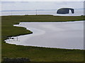
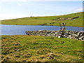
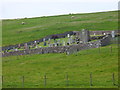
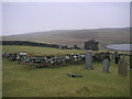
This well-preserved burnt mound is located on the eastern bank of Loch of Breckon. It reaches 18 x 10m dimensions and 1.20m of height. Part of its structure with burnt stones is exposed.
Canmore entry
You may be viewing yesterday's version of this page. To see the most up to date information please register for a free account.
")
")
Do not use the above information on other web sites or publications without permission of the contributor.
Nearby Images from Geograph Britain and Ireland:
©2010(licence)
©2009(licence)
©2019(licence)
©2010(licence)
©2007(licence)
The above images may not be of the site on this page, they are loaded from Geograph.
Please Submit an Image of this site or go out and take one for us!
Click here to see more info for this site
Nearby sites
Key: Red: member's photo, Blue: 3rd party photo, Yellow: other image, Green: no photo - please go there and take one, Grey: site destroyed
Download sites to:
KML (Google Earth)
GPX (GPS waypoints)
CSV (Garmin/Navman)
CSV (Excel)
To unlock full downloads you need to sign up as a Contributory Member. Otherwise downloads are limited to 50 sites.
Turn off the page maps and other distractions
Nearby sites listing. In the following links * = Image available
379m W 270° Sae Breck* Broch or Nuraghe (HU21057803)
1.1km N 359° Loch of Houlland* Broch or Nuraghe (HU2140079160)
3.6km NE 44° Hamnavoe Broch* Broch or Nuraghe (HU2389380641)
3.8km NE 50° Giant's Stones Row (Shetland)* Multiple Stone Rows / Avenue (HU243805)
3.8km NE 49° Giant's Stones (Shetland)* Standing Stones (HU2431280555)
6.6km E 87° Burnside Burnt Mound* Artificial Mound (HU28057842)
7.7km E 90° Gateside Chambered Cairn* Chambered Cairn (HU29137811)
12.9km ESE 122° Pund's Water* Chambered Cairn (HU32457124)
15.3km SE 129° Islesburgh* Chambered Cairn (HU33456845)
16.4km NE 43° Beorgs of Uyea neolithic axe factory* Ancient Mine, Quarry or other Industry (HU3268990052)
16.5km ENE 64° Beorgs of Housetter* Standing Stones (HU36178546)
16.5km NE 44° Beorgs of Uyea chambered cairn* Chambered Cairn (HU3278890043)
16.5km ENE 63° Trowie Knowe* Chambered Cairn (HU36208552)
17.1km SE 129° Busta Brae* Standing Stones (HU34886739)
18.9km SSE 155° Vementry* Chambered Cairn (HU296609)
19.0km SSW 195° Doom Rings Stone Circle (HU166596)
19.3km SSW 194° Papa Stour Chambered Cairn (HU17025924)
19.6km S 187° Holm of Melby NE Chambered Cairn (HU19315856)
19.6km S 187° Holm of Melby NW Cairn (HU19195856)
19.6km S 187° Holm of Melby South Cairn (HU19225851)
19.7km S 180° Ness of Garth* Promontory Fort / Cliff Castle (HU216583)
19.8km S 180° Bay of Garth Broch or Nuraghe (HU216582)
20.5km S 187° Sandness Class I Pictish Symbol Stone (HU19125765)
20.5km S 180° Rinns of Shurdimires* Stone Row / Alignment (HU2171057489)
20.5km S 178° Broch of Brousta Broch or Nuraghe (HU223575)
View more nearby sites and additional images


 We would like to know more about this location. Please feel free to add a brief description and any relevant information in your own language.
 Wir möchten mehr über diese Stätte erfahren. Bitte zögern Sie nicht, eine kurze Beschreibung und relevante Informationen in Deutsch hinzuzufügen.
 Nous aimerions en savoir encore un peu sur les lieux. S'il vous plaît n'hesitez pas à ajouter une courte description et tous les renseignements pertinents dans votre propre langue.
 Quisieramos informarnos un poco más de las lugares. No dude en añadir una breve descripción y otros datos relevantes en su propio idioma.