


<< Our Photo Pages >> St Mary and St Helen (Neston) - Ancient Cross in England in Cheshire
Submitted by TimPrevett on Sunday, 01 July 2007 Page Views: 11051
Early MedievalSite Name: St Mary and St Helen (Neston) Alternative Name: Neston Parish ChurchCountry: England County: Cheshire Type: Ancient Cross
Nearest Town: Neston
Map Ref: SJ2915077449
Latitude: 53.289250N Longitude: 3.064287W
Condition:
| 5 | Perfect |
| 4 | Almost Perfect |
| 3 | Reasonable but with some damage |
| 2 | Ruined but still recognisable as an ancient site |
| 1 | Pretty much destroyed, possibly visible as crop marks |
| 0 | No data. |
| -1 | Completely destroyed |
| 5 | Superb |
| 4 | Good |
| 3 | Ordinary |
| 2 | Not Good |
| 1 | Awful |
| 0 | No data. |
| 5 | Can be driven to, probably with disabled access |
| 4 | Short walk on a footpath |
| 3 | Requiring a bit more of a walk |
| 2 | A long walk |
| 1 | In the middle of nowhere, a nightmare to find |
| 0 | No data. |
| 5 | co-ordinates taken by GPS or official recorded co-ordinates |
| 4 | co-ordinates scaled from a detailed map |
| 3 | co-ordinates scaled from a bad map |
| 2 | co-ordinates of the nearest village |
| 1 | co-ordinates of the nearest town |
| 0 | no data |
Internal Links:
External Links:
 (PID:38698)")
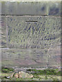
The carvings feature cable mouldings and interlace patterns alongside figural scenes showing priests in vestments, biblical episodes, hunting scenes, and horsemen in combat. Ring-headed cross designs are comparable to examples from West Kirby and Chester, suggesting a local "school" or workshop of stone carvers. The fragments represent a community actively commissioning Christian commemorative monuments while maintaining secular aristocratic themes in their visual culture.
The stones are well-lit and accessible from all sides beside the south door to the nave. Interpretive materials include printed information sheets and a colourised replica stone originally produced for the Grosvenor Museum in Chester. Digital records are also available through the CASSS (Corpus of Anglo-Saxon Stone Sculpture) website.
References:
Williams, H. (2020) "Neston's Early Medieval Stones", Archaeodeath blog
howardwilliamsblog.wordpress.com/2020/12/19/nestons-early-medieval-stones/
You may be viewing yesterday's version of this page. To see the most up to date information please register for a free account.
Do not use the above information on other web sites or publications without permission of the contributor.
Nearby Images from Geograph Britain and Ireland:
©2011(licence)
©2019(licence)

©2010(licence)
©2018(licence)

©2019(licence)
The above images may not be of the site on this page, they are loaded from Geograph.
Please Submit an Image of this site or go out and take one for us!
Click here to see more info for this site
Nearby sites
Key: Red: member's photo, Blue: 3rd party photo, Yellow: other image, Green: no photo - please go there and take one, Grey: site destroyed
Download sites to:
KML (Google Earth)
GPX (GPS waypoints)
CSV (Garmin/Navman)
CSV (Excel)
To unlock full downloads you need to sign up as a Contributory Member. Otherwise downloads are limited to 50 sites.
Turn off the page maps and other distractions
Nearby sites listing. In the following links * = Image available
3.5km ENE 65° Raby Mound Round Barrow(s) (SJ32377891)
3.6km SSE 149° Hampston's Well* Holy Well or Sacred Spring (SJ3099074309)
4.0km SSE 164° Burton Point* Promontory Fort / Cliff Castle (SJ302736)
6.0km SW 231° Stone Circles, Flint Country Park (Modern)* Modern Stone Circle etc (SJ2441773744)
6.2km SW 230° Stone Circle, Flint Industrial Estate (Modern)* Modern Stone Circle etc (SJ2432473575)
7.1km NNE 18° Red Hill Mound Artificial Mound (SJ31458412)
7.4km SSE 148° Modern Stones at Deeside Industrial Area* Modern Stone Circle etc (SJ330711)
7.5km NE 49° St Barnabas (Bromborough)* Ancient Cross (SJ3491082212)
7.5km WSW 258° Bagillt Stonehenge (Modern)* Modern Stone Circle etc (SJ2179576045)
7.7km NE 43° St Patrick's Well (Bromborough)* Holy Well or Sacred Spring (SJ34538295)
8.0km NNE 30° Meyer Park Stone Circle* Modern Stone Circle etc
8.8km NNW 345° Arrowe Park standing stones Standing Stones (SJ27058596)
8.8km NNW 327° Thor's Stone* Natural Stone / Erratic / Other Natural Feature (SJ2447484933)
9.8km NNW 339° Greasby Copse Ancient Village or Settlement (SJ25788664)
10.0km NW 322° Face Stone (Stapledon Wood)* Rock Outcrop (SJ23088536)
10.0km W 266° Wat's Dyke (Holywell and Basingwerk)* Misc. Earthwork (SJ1914676949)
10.7km W 263° St Winefrides Well* Holy Well or Sacred Spring (SJ18517627)
11.5km NW 322° The Column* Chambered Tomb (SJ22248662)
11.6km NW 320° St Bridget (West Kirby)* Early Christian Sculptured Stone (SJ21828641)
11.6km SW 223° Moel-y-Gaer Circle Timber Circle (SJ211691)
11.6km SW 223° Moel-y-Gaer (Flintshire)* Hillfort (SJ21116904)
11.6km NW 322° West Kirby Cremation Burial Cist (SJ22158678)
11.7km NNW 346° Overchurch* Stone Circle (SJ264888)
11.7km N 5° The Bonks Barrow Cemetery (SJ303891)
11.8km WSW 243° Parc y Prysau 2 Round Barrow(s) (SJ185723)
View more nearby sites and additional images


 We would like to know more about this location. Please feel free to add a brief description and any relevant information in your own language.
 Wir möchten mehr über diese Stätte erfahren. Bitte zögern Sie nicht, eine kurze Beschreibung und relevante Informationen in Deutsch hinzuzufügen.
 Nous aimerions en savoir encore un peu sur les lieux. S'il vous plaît n'hesitez pas à ajouter une courte description et tous les renseignements pertinents dans votre propre langue.
 Quisieramos informarnos un poco más de las lugares. No dude en añadir una breve descripción y otros datos relevantes en su propio idioma.