<< Text Pages >> Ter Hill Cross - Ancient Cross in England in Devon
Submitted by Anne T on Tuesday, 11 June 2019 Page Views: 757
Early Medieval (Dark Age)Site Name: Ter Hill CrossCountry: England County: Devon Type: Ancient Cross
Nearest Town: Princetown / Two Bridges Nearest Village: Hexworthy / Dartmeet
Map Ref: SX6403670623
Latitude: 50.519556N Longitude: 3.919279W
Condition:
| 5 | Perfect |
| 4 | Almost Perfect |
| 3 | Reasonable but with some damage |
| 2 | Ruined but still recognisable as an ancient site |
| 1 | Pretty much destroyed, possibly visible as crop marks |
| 0 | No data. |
| -1 | Completely destroyed |
| 5 | Superb |
| 4 | Good |
| 3 | Ordinary |
| 2 | Not Good |
| 1 | Awful |
| 0 | No data. |
| 5 | Can be driven to, probably with disabled access |
| 4 | Short walk on a footpath |
| 3 | Requiring a bit more of a walk |
| 2 | A long walk |
| 1 | In the middle of nowhere, a nightmare to find |
| 0 | No data. |
| 5 | co-ordinates taken by GPS or official recorded co-ordinates |
| 4 | co-ordinates scaled from a detailed map |
| 3 | co-ordinates scaled from a bad map |
| 2 | co-ordinates of the nearest village |
| 1 | co-ordinates of the nearest town |
| 0 | no data |
Be the first person to rate this site - see the 'Contribute!' box in the right hand menu.
Internal Links:
External Links:
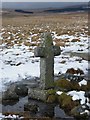
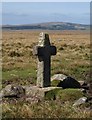
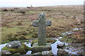
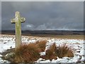
Ancient Cross in Devon
The original of this cross, with its replacement socket stone, is now located in the National Park Visitor Centre in Princetown - see our entry for High Moorland Visitor Centre (SID 26605).
The information board at the Visitor Centre reads: "(This) Latin style granite cross originally stood on Ter Hill, one of the highest points on southern Dartmoor. It was one in a line of medieval wayside crosses marking the ancient Monks’ Path, linking Buckfast Abbey to Tavistock and Buckland Abbeys. Over the years this cross became badly damaged by cattle using it as a rubbing post. In 1885 the Dartmoor Preservation Association repaired it with iron clamps. By 1984 it had fallen over again and its shaft was broken. Dartmoor National Park’s Conservation Team carried out further repairs, but it was too fragile to return to the moor, it they decided to locate it to this garden in Princetown. A replica cross was made in 1994, which stands at the original site on Ter Hill”, when the original was moved to the Visitor Centre in Princetown.
F.H Starkey in his 1983 book “Dartmoor Crosses & Some Ancient Tracks” describes two adjacent crosses at this location: “We are now making for the summit of a hill about a mile to the SW of the cross on Down Ridge – Ter Hill. As we draw nearer, we discern what appears to be a post standing near the summit, black against the skyline. On reaching this it turns out to be another cross, but sited in such a way that the arms are in line with the path and not across it so that it is not easily recognisable at a distance. This is unusual if not unique and is probably the result of thoughtlessness when the cross was re-erected. This cross stands rather less than six feet high (it measured six feet six inches before re-erection in 1885) and it is to all intents and purposes undamaged. It measures two feet two inches across the arms".
"About a hundred yards to the west of the cross just described, stands another[The Ter Hill Cross]. This is shorter than the last and has been damaged and repaired by an iron clamp. Crossing tells the story of how a farmer at Sherburton in the valley of the Swincombe below Tor Hill took a fancy to this cross at some period in the 19th century and removed it and set it up in his farmyard. The Duchy objected to this however and it was returned and left lying at its original site until it was re-erected in 1885”.
This cross is recorded as Pastscape Monument No 443316 and scheduled asHistoric England List ID 1002618.
Note: Have you seen this replica of the Ter Hill Cross? Do you have any photographs or information to add?
You may be viewing yesterday's version of this page. To see the most up to date information please register for a free account.
Do not use the above information on other web sites or publications without permission of the contributor.
Nearby Images from Geograph Britain and Ireland:
©2020(licence)
©2009(licence)
©2007(licence)
©2009(licence)
©2020(licence)
The above images may not be of the site on this page, they are loaded from Geograph.
Please Submit an Image of this site or go out and take one for us!
Click here to see more info for this site
Nearby sites
Key: Red: member's photo, Blue: 3rd party photo, Yellow: other image, Green: no photo - please go there and take one, Grey: site destroyed
Download sites to:
KML (Google Earth)
GPX (GPS waypoints)
CSV (Garmin/Navman)
CSV (Excel)
To unlock full downloads you need to sign up as a Contributory Member. Otherwise downloads are limited to 50 sites.
Turn off the page maps and other distractions
Nearby sites listing. In the following links * = Image available
1.1km E 85° Skir Hill* Cairn (SX65097068)
1.2km WNW 285° Fox Tor Newtake South* Cairn (SX62867097)
1.3km WNW 293° Fox Tor Newtake North* Cist (SX62867116)
1.5km WSW 256° Childe’s Tomb* Cairn (SX62577030)
1.6km NNW 327° Joan Ford Newtake row* Multiple Stone Rows / Avenue (SX6318071989)
1.8km NNW 328° Joan Ford Newtake E* Cairn (SX63147216)
1.8km NW 326° Joan Ford Newtake W* Cairn (SX63047218)
1.9km NW 325° Tor Royal Cairn (SX62967224)
2.1km NE 47° Down Ridge Outlier* Standing Stone (Menhir) (SX65577200)
2.1km NE 44° Down Ridge* Stone Circle (SX6550872068)
2.2km W 263° Goldsmith Cross E1 Cist (SX61877040)
2.2km W 261° Rha cairn circle and cist* Cist (SX6180470321)
2.3km WSW 258° Goldsmith's Cross E3 Cist (SX6174170204)
2.5km NNW 342° Swincombe cairn circle and cist* Cist (SX63327298)
2.5km SE 128° Ryder's Hill* Cairn (SX65976906)
2.5km NW 304° Royal Hill Cairns (SX620721)* Cairn (SX6201872079)
2.5km WSW 250° Whealam cist* Cist (SX61666985)
2.6km N 356° Sherberton circle* Stone Circle (SX6394073173)
2.6km NW 306° Royal Hill Cairns* Cairn (SX620722)
2.6km WNW 299° Royal Hill Cairns (SX618719)* Cairn (SX6181271945)
2.6km NW 310° Royal Hill Cairns (SX621723)* Cairn (SX6208272334)
2.6km NW 312° Royal Hill Cairns (SX621724)* Cairn (SX6210872434)
2.6km ENE 77° Holne Ridge North* Cist (SX6664171138)
2.7km N 356° Sherberton Row* Stone Row / Alignment (SX63917336)
2.7km ENE 79° Holne Ridge NE* Multiple Stone Rows / Avenue (SX66757109)
View more nearby sites and additional images


 We would like to know more about this location. Please feel free to add a brief description and any relevant information in your own language.
 Wir möchten mehr über diese Stätte erfahren. Bitte zögern Sie nicht, eine kurze Beschreibung und relevante Informationen in Deutsch hinzuzufügen.
 Nous aimerions en savoir encore un peu sur les lieux. S'il vous plaît n'hesitez pas à ajouter une courte description et tous les renseignements pertinents dans votre propre langue.
 Quisieramos informarnos un poco más de las lugares. No dude en añadir una breve descripción y otros datos relevantes en su propio idioma.