

<< Our Photo Pages >> Esgair Garn - Cairn in Wales in Powys
Submitted by pjk7009 on Saturday, 17 January 2015 Page Views: 3212
Neolithic and Bronze AgeSite Name: Esgair Garn Alternative Name: Esgair Garn Cairn, Llanddewi AbergwesynCountry: Wales County: Powys Type: Cairn
Map Ref: SN83084983
Latitude: 52.134361N Longitude: 3.709665W
Condition:
| 5 | Perfect |
| 4 | Almost Perfect |
| 3 | Reasonable but with some damage |
| 2 | Ruined but still recognisable as an ancient site |
| 1 | Pretty much destroyed, possibly visible as crop marks |
| 0 | No data. |
| -1 | Completely destroyed |
| 5 | Superb |
| 4 | Good |
| 3 | Ordinary |
| 2 | Not Good |
| 1 | Awful |
| 0 | No data. |
| 5 | Can be driven to, probably with disabled access |
| 4 | Short walk on a footpath |
| 3 | Requiring a bit more of a walk |
| 2 | A long walk |
| 1 | In the middle of nowhere, a nightmare to find |
| 0 | No data. |
| 5 | co-ordinates taken by GPS or official recorded co-ordinates |
| 4 | co-ordinates scaled from a detailed map |
| 3 | co-ordinates scaled from a bad map |
| 2 | co-ordinates of the nearest village |
| 1 | co-ordinates of the nearest town |
| 0 | no data |
Internal Links:
External Links:
I have visited· I would like to visit
geoffstickland would like to visit
")
An obvious outcrop of this material was not observed in the immediate area around the cairn (OS 1977)
Source: O.S. Card SN 84 NW 3.
Helen Whitear and Duncan Schlee, Dyfed Archaeological Trust, January 2008
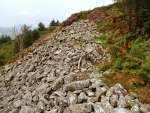
Coflein; On the west end of Esgair Garn 465 m above O.D. on the crest of a moorland spur is a circular stone-built cairn, which includes blocks of quartz. It is 15.9 m in diameter and 0.9 m high at the center, where a modern cairn adds 0.6 m of height.
You may be viewing yesterday's version of this page. To see the most up to date information please register for a free account.
Do not use the above information on other web sites or publications without permission of the contributor.
Nearby Images from Geograph Britain and Ireland:

©2008(licence)

©2009(licence)

©2008(licence)

©2009(licence)

©2009(licence)
The above images may not be of the site on this page, they are loaded from Geograph.
Please Submit an Image of this site or go out and take one for us!
Click here to see more info for this site
Nearby sites
Key: Red: member's photo, Blue: 3rd party photo, Yellow: other image, Green: no photo - please go there and take one, Grey: site destroyed
Download sites to:
KML (Google Earth)
GPX (GPS waypoints)
CSV (Garmin/Navman)
CSV (Excel)
To unlock full downloads you need to sign up as a Contributory Member. Otherwise downloads are limited to 50 sites.
Turn off the page maps and other distractions
Nearby sites listing. In the following links * = Image available
528m SE 127° Cefn Blaencwmhenog Cairn* Cairn (SN8349449500)
1.7km SW 225° Mynydd Trawsnant Cairn* Cairn (SN81834863)
1.9km SSW 201° Croes Llywd Fach Cairn* Cairn (SN82374808)
2.7km S 182° Cnapau Hafodllewelyn Cairn* Cairn (SN82934711)
2.8km E 88° Cwm Irfon Standing Stone* Standing Stone (Menhir) (SN85844984)
2.8km SW 220° Cefn Ystrad Ffin Cairn* Cairn (SN81234776)
2.9km ENE 77° Craig Dinas Fach Hill Fort (possible)* Hillfort (SN85955041)
3.4km ESE 120° Pen y Ddinas Hillfort - possible* Hillfort (SN86024805)
3.5km NE 37° Ffynnon Ddewi (Abergwesyn)* Holy Well or Sacred Spring (SN8529852598)
3.6km SE 137° Banc y Ddinas - possible Hill Fort/Defended Enclosure* Hillfort (SN85504715)
3.7km SSE 152° Waun Coli* Cairn (SN84754658)
3.9km ESE 121° Ystafell Fach Sculptured Stone* Early Christian Sculptured Stone (SN86364777)
4.2km SSE 155° Garn Wen (Llanwrtyd Wells)* Cairn (SN84754597)
4.4km ESE 112° Garn Dwad cairn* Cairn (SN871481)
4.4km SW 220° Cerrig Cedny* Cairn (SN80144651)
4.5km SW 216° Carn Twrch* Cairn (SN80344630)
4.6km SE 136° Banc Glyn Gyrnant Enclosure* Hillfort (SN862465)
4.8km S 191° Cynant Fach Cairn* Cairn (SN82054515)
4.8km SSW 212° Carreg Craig y Moch Standing Stone (Menhir) (SN804458)
4.8km SE 140° Pen Garn Goy possible Bronze Age Barrow* Cairn (SN86144607)
4.8km SE 139° Penmaenllwyd Cairn* Cairn (SN8617346091)
5.1km NNE 17° Esgair Irfon Cairn* Cairn (SN84645464)
5.2km ENE 58° Banc Paderau* Ring Cairn (SN8757652484)
5.4km E 85° Pen y Garn Goch* Chambered Tomb (SN885502)
5.6km SW 214° Carn Wen (Rhandirmwyn)* Cairn (SN79834527)
View more nearby sites and additional images


 We would like to know more about this location. Please feel free to add a brief description and any relevant information in your own language.
 Wir möchten mehr über diese Stätte erfahren. Bitte zögern Sie nicht, eine kurze Beschreibung und relevante Informationen in Deutsch hinzuzufügen.
 Nous aimerions en savoir encore un peu sur les lieux. S'il vous plaît n'hesitez pas à ajouter une courte description et tous les renseignements pertinents dans votre propre langue.
 Quisieramos informarnos un poco más de las lugares. No dude en añadir una breve descripción y otros datos relevantes en su propio idioma.