 with our Megalithic Portal iPhone app")

<< Our Photo Pages >> Robin Hood's Tump - Round Barrow(s) in England in Cheshire
Submitted by TimPrevett on Wednesday, 26 November 2003 Page Views: 10999
Neolithic and Bronze AgeSite Name: Robin Hood's TumpCountry: England County: Cheshire Type: Round Barrow(s)
Nearest Town: Nantwich Nearest Village: Alpraham
Map Ref: SJ575599 Landranger Map Number: 117
Latitude: 53.134552N Longitude: 2.636701W
Condition:
| 5 | Perfect |
| 4 | Almost Perfect |
| 3 | Reasonable but with some damage |
| 2 | Ruined but still recognisable as an ancient site |
| 1 | Pretty much destroyed, possibly visible as crop marks |
| 0 | No data. |
| -1 | Completely destroyed |
| 5 | Superb |
| 4 | Good |
| 3 | Ordinary |
| 2 | Not Good |
| 1 | Awful |
| 0 | No data. |
| 5 | Can be driven to, probably with disabled access |
| 4 | Short walk on a footpath |
| 3 | Requiring a bit more of a walk |
| 2 | A long walk |
| 1 | In the middle of nowhere, a nightmare to find |
| 0 | No data. |
| 5 | co-ordinates taken by GPS or official recorded co-ordinates |
| 4 | co-ordinates scaled from a detailed map |
| 3 | co-ordinates scaled from a bad map |
| 2 | co-ordinates of the nearest village |
| 1 | co-ordinates of the nearest town |
| 0 | no data |
Internal Links:
External Links:
I have visited· I would like to visit
TimPrevett has visited here
")
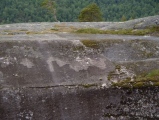
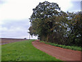
Robin Hood's Tump SJ575599 - the remains of a bowl or round barrow (National Monuments Record gives it as a bowl barrow), over a possible settlement, not far off the A51 near Tilstone Fearnall. The access was surprisingly good - on a very wide corner, giving plenty of space for unobtrustive parking. Largely unremarkable, given no burials have been found here, but as I have spent longer, and searched harder trying to find much less, this was a rewarding bump to find! Given the heavy tree covering, late autumn / winter is best for a visit - but mind the brambles - I got very well scratched even through trousers! The mound is also topped by a "Ministry of Works" sign, denoting it as a scheduled ancient monument, and it is partitioned off well from adjoining fields, so it should be afforded protection for a long, long time.
You may be viewing yesterday's version of this page. To see the most up to date information please register for a free account.
")
")
")
")
Do not use the above information on other web sites or publications without permission of the contributor.
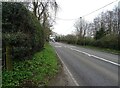
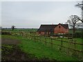
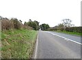
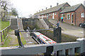
Nearby Images from Geograph Britain and Ireland:
©2024(licence)
©2024(licence)
©2024(licence)
©2006(licence)
©2005(licence)
The above images may not be of the site on this page, they are loaded from Geograph.
Please Submit an Image of this site or go out and take one for us!
Click here to see more info for this site
Nearby sites
Key: Red: member's photo, Blue: 3rd party photo, Yellow: other image, Green: no photo - please go there and take one, Grey: site destroyed
Download sites to:
KML (Google Earth)
GPX (GPS waypoints)
CSV (Garmin/Navman)
CSV (Excel)
To unlock full downloads you need to sign up as a Contributory Member. Otherwise downloads are limited to 50 sites.
Turn off the page maps and other distractions
Nearby sites listing. In the following links * = Image available
3.8km W 259° Beeston Castle* Hillfort (SJ538592)
3.9km SW 235° Peckforton Mere* Ancient Village or Settlement (SJ543577)
4.0km NW 325° Salterswell* Holy Well or Sacred Spring (SJ552632)
6.7km NNW 342° High Billinge* Round Barrow(s) (SJ5548066242)
7.2km N 350° Seven Lows Round Barrow(s) (SJ56336703)
7.2km N 353° Seven Lows* Round Barrow(s) (SJ567671)
7.5km NNW 338° Whistlebitch Well* Holy Well or Sacred Spring (SJ548669)
7.9km N 0° Oakmere* Ancient Village or Settlement (SJ576678)
8.2km NNE 17° Long Stone Cross* Ancient Cross (SJ599677)
8.7km WNW 297° Brookhouse Farm Ancient Village or Settlement (SJ497639)
8.8km NNW 330° Kelsborrow Castle* Hillfort (SJ5315567509)
8.9km SE 140° Church of St Mary the Virgin (Acton)* Ancient Cross (SJ63175308)
9.7km NNW 336° Delamere Stone Circle (SJ536688)
9.7km NNW 346° Castle Ditch Eddisbury* Hillfort (SJ553694)
10.4km SW 227° Maiden Castle (Cheshire)* Hillfort (SJ49805286)
10.5km SE 135° Old Biot* Holy Well or Sacred Spring (SJ64965243)
11.1km WSW 245° St Winefride's (Clutton)* Holy Well or Sacred Spring (SJ47395524)
11.4km N 357° Gallowsclough Cob* Round Barrow(s) (SJ570713)
12.3km NE 39° Moultonbank Farm Round Barrow(s) (SJ653694)
12.8km WSW 240° Carden Park* Cave or Rock Shelter (SJ463537)
12.8km WSW 240° Carden Park Barrow Round Barrow(s) (SJ46365352)
13.2km NNW 343° Glead Hill Cob Round Barrow(s) (SJ538726)
14.1km NNW 343° Castle Cob* Round Barrow(s) (SJ535734)
15.6km NW 310° St Plegmund's Well* Holy Well or Sacred Spring (SJ457701)
16.7km SW 226° Meadows Farm Barrow* Round Barrow(s) (SJ45454834)
View more nearby sites and additional images


 We would like to know more about this location. Please feel free to add a brief description and any relevant information in your own language.
 Wir möchten mehr über diese Stätte erfahren. Bitte zögern Sie nicht, eine kurze Beschreibung und relevante Informationen in Deutsch hinzuzufügen.
 Nous aimerions en savoir encore un peu sur les lieux. S'il vous plaît n'hesitez pas à ajouter une courte description et tous les renseignements pertinents dans votre propre langue.
 Quisieramos informarnos un poco más de las lugares. No dude en añadir una breve descripción y otros datos relevantes en su propio idioma.